Related Research Articles

The Cariboo is an intermontane region of British Columbia along a plateau stretching from the Fraser Canyon to the Cariboo Mountains. The name is a reference to the caribou that were once abundant in the region. The Cariboo was the first region of the Interior north of the lower Fraser and its canyon to be settled by non-indigenous people, and played an important part in the early history of the colony and province. The boundaries of the Cariboo proper in its historical sense are debatable, but its original meaning was the region north of the forks of the Quesnel River and the low mountainous basins between the mouth of that river on the Fraser at the city of Quesnel and the northward end of the Cariboo Mountains - an area that is mostly in the Quesnel Highland and focused on several now-famous gold-bearing creeks near the head of the Willow River, the richest of them all, Williams Creek, the location of Barkerville, which was the capital of the Cariboo Gold Rush and also of government officialdom for decades afterwards. This area, the Cariboo goldfields, is underpopulated today but was once the most settled and most powerful of the regions of the province's Interior. As settlement spread southwards of this area, flanking the route of the Cariboo Road and spreading out through the rolling plateaus and benchlands of the Cariboo Plateau and lands adjoining it along the Fraser and Thompson, the meaning changed to include a wider area than the goldfields.
Flat Lake Provincial Park is a provincial park in British Columbia, Canada.
Sabine Channel Provincial Park, also known as Sabine Channel Marine Provincial Park, is a provincial park in British Columbia, Canada, in the waters surrounding Jervis Island in Sabine Channel, which separates Texada Island (N) from Lasqueti Island (S). Established in 2001, the parks is approximately 95 ha. in size.
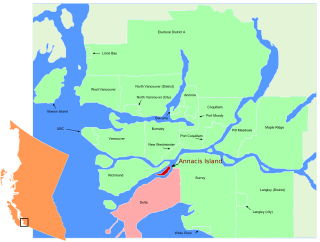
Annacis Island is an island located in the south arm of the Fraser River, in Delta, British Columbia. The island is now mostly industrial, and it contains one of Metro Vancouver's secondary wastewater treatment plants.
Errington is a small community on Vancouver Island, British Columbia, Canada, located on Errington Road, off Highway 4, just south of Parksville and Qualicum Beach.

The Gwa'Sala-Nakwaxda'xw Nations are a union of two Kwakwaka'wakw peoples in a band government based on northern Vancouver Island in British Columbia, Canada, whose main reserve community is near the town of Port Hardy in the Queen Charlotte Strait region of the Central Coast region of British Columbia, Canada. The band government is a member of the Kwakiutl District Council and, for treaty negotiation purposes, the Winalagalis Treaty Group which includes three other members of the Kwakiutl District Council.
The Tl'etinqox-t'in Government Office is a First Nations government located in the Chilcotin District in the western Central Interior region of the Canadian province of British Columbia. Governing a reserve communities near Alexis Creek known as Anaham Reserve First Nations or Anaham, it is a member of the Tsilhqot'in Tribal Council aka known as the Tsilhqot'in National Government. The main reserve is officially known as Anahim's Flat No. 1, and is more commonly as Anaham. Other reserves are Anahim's Meadow No. 2 and 2A, and Anahim Indian Reserves Nos. 3 through 18. Anaham, or Anahim and Alexis were chiefs of the Tsilhqot'in during the Chilcotin War of 1864, although they and their people did not take part in the hostilities.
The Similkameen Country, also referred to as the Similkameen Valley or Similkameen District, but generally referred to simply as The Similkameen or more archaically, Similkameen, is a region roughly coinciding with the basin of the river of the same name in the Southern Interior of British Columbia. The term "Similkameen District" also refers to the Similkameen Mining District, a defunct government administrative district, which geographically encompasses the same area, and in more casual terms may also refer to the Similkameen electoral district, which was combined with the Grand Forks-Greenwood riding by the time of the 1966 election. The Similkameen Country has deep historical connections to the Boundary Country and the two are sometimes considered one region, partly as a result of the name of the electoral district. It is also sometimes classed as being part of the Okanagan region, which results from shared regional district and other administrative boundaries and names. The term "Similkameen District" may also historically refer to the Similkameen Division Yale Land District, which also includes Osoyoos and the Boundary Country to Osoyoos' east.
Douglas is a locality in Surrey, British Columbia, Canada, just southeast and outside of the boundary of White Rock, that is the Canadian side of the Peace Arch Border Crossing between British Columbia and Whatcom County, Washington in the United States. Douglas is the location of the Peace Arch Provincial Park portion of the International Peace Arch Park, which it shares with Peace Arch State Park in Blaine, Washington. The community is named for Benjamin Douglas, an early pioneer.
Silverdale is a semi-rural neighbourhood of the District of Mission, British Columbia, Canada c. 40 km east of Vancouver on the east bank of the Stave River at its confluence with the Fraser. Noted for its historic Italian Canadian community, its economy was farming, fishing and logging based until the general suburbanization of Fraser Valley life in the 1960s and '70s. Of its Italian community, notable offspring include Phil Gaglardi, former BC Highways minister, and speed-skater Eden Donatelli. Silverdale is also notable as the site of Canada's first train robbery, by the "Gentleman Bandit" Billy Miner, and it is there he is supposed to have first used the polite "Hands Up!" in the course of the robbery.

The Katzie First Nation or Katzie Nation is the band government of the Katzie people of the Lower Fraser Valley region of British Columbia, Canada.

The Ashnola River is a tributary of the Similkameen River, rising in the northeastern part of the North Cascades in Washington, United States, and flowing north into British Columbia, Canada, to join the Similkameen River about halfway along that river's course between the towns of Princeton and Keremeos. The river crosses the international boundary at 49°00′00″N120°19′37″W and transits Cathedral Provincial Park. It has one main tributary, Ewart Creek, which is about 25 kilometres (16 mi) long and begins virtually at the border and is entirely within Cathedral Park.
Kanaka Creek Regional Park is a regional park of the Greater Vancouver Regional District, located in the District of Maple Ridge, British Columbia, flanking both sides of Kanaka Creek from its confluence with the Fraser River just east of Haney and extending approximately 11 km up the creek to just south of the community of Webster's Corners.
Flood is a rural community in the District of Hope, British Columbia, Canada, located west of the town of Hope on the south bank of the Fraser River in the far eastern end of the Fraser Valley region. It is primarily agricultural in nature. Its official name is Floods though it is usually referred to by its post office name in the singular, Flood.
Cascade Falls is a waterfall on the Kettle River in the Boundary Country of the Southern Interior of British Columbia. They are located just south of Christina Lake and just north of the Canada–United States border in a gorge 200-300 yards long and just below the railway bridge over the Kettle by the southern mainline of the Canadian Pacific Railway. The ghost town of Cascade City aka Cascade is nearby and was named for the falls, even though they were not officially named until 1977.
Sapperton is a neighbourhood of the City of New Westminster, British Columbia, Canada, located in the northeastern end of that city and up to its boundaries with the City of Coquitlam and City of Burnaby. Located on the slope above the Fraser River and focused on Brunette Avenue and Columbia Street, and northeast of the former British Columbia Penitentiary, the neighbourhood was the location of the barracks and other housing for the Royal Engineers, Columbia Detachment, who were known as "sappers", hence the name.
The Douglas First Nation, aka the Douglas Indian Band, Douglas Band, or Xa'xtsa First Nation, are a band government of the In-SHUCK-ch Nation, a subgroup of the larger St'at'imc people, also referred to as Lower Stl'atl'imx. The Douglas, Skatin and Samahquam communities are related through familial ties as well as culturally and linguistically. The In-SHUCK-ch are the southernmost of the four divisions making up the Lillooet ethnographic group. The Douglas First Nation's main community is at Xa'xtsa, a village on their main reserve at the head of Harrison Lake, near the former gold rush port-town of Port Douglas.
The Leq' a: mel First Nation, formerly known as the Lakahahmen First Nation, is a First Nations band government whose community and offices are located in the area near Deroche, British Columbia, Canada, about 12 kilometres east of the District of Mission. They are a member government of the Sto:lo Nation tribal council, which is one of two tribal councils of the Sto:lo.
References
- ↑ "Webster's Corners". BCGNIS. Retrieved 15 January 2012.
- ↑ Akrigg, G.P.V.; Akrigg, Helen B. (1986), British Columbia Place Names (3rd, 1997 ed.), Vancouver: UBC Press, ISBN 0-7748-0636-2
Coordinates: 49°13′00″N122°31′00″W / 49.21667°N 122.51667°W
| This article about a location in British Columbia, Canada is a stub. You can help Wikipedia by expanding it. |