Related Research Articles

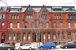
NoHo, short for "North of Houston Street", is a primarily residential neighborhood in Lower Manhattan, New York City. It is bounded by Mercer Street to the west, the Bowery to the east, 9th Street to the north, and Houston Street to the south.

Hayes Valley is a neighborhood in the Western Addition district of San Francisco, California. It is located between the historical districts of Alamo Square and the Civic Center. Victorian, Queen Anne, and Edwardian townhouses are mixed with high-end boutiques, restaurants, and public housing complexes. The neighborhood gets its name from Hayes Street, which was named for Thomas Hayes, San Francisco's county clerk from 1853 to 1856 who also started the first Market Street Railway franchise.
Kirkwood is a nationally designated historic neighborhood on the east side of Atlanta, Georgia, United States. It is an historic streetcar suburb situated entirely in DeKalb County, bordered by the neighborhoods of Lake Claire, East Lake, Edgewood, and Oakhurst. Kirkwood is bound on the north by DeKalb Avenue, on the south by Memorial Drive and Interstate 20, on the west by Montgomery Street, and on the east by 1st Ave. A large part of the neighborhood is listed on the National Register of Historic Places as Kirkwood Historic District.
The Main Street District of downtown Dallas, Texas runs along Main Street and is bounded by Elm Street one block north, Commerce St. one block south, N. Lamar St. to the west, and US 75/I-45 (I-345) elevated highway to the east. The district is the spine of downtown Dallas, and connects many of the adjoining business and entertainment districts. It does not include Dealey Plaza or the John Fitzgerald Kennedy Memorial which are a few blocks west in the West End Historic District.

The Cedars is a district in Dallas, Texas (U.S.). It is adjacent to and south of downtown and Interstate 30, east of Austin Street, north of Corinth Street, and west of the 75 & 345 Overpasses just east of South Good Latimer Expy.

Civic Center, Denver is a neighborhood in Denver, Colorado, United States. The northern part of the neighborhood overlaps partially with the Denver Civic Center, an area of parks and civic buildings.
The Station North Arts and Entertainment District is an area and official arts and entertainment district in the U.S. city of Baltimore, Maryland. The neighborhood is marked by a combination of artistically-leaning commercial ventures, such as theaters and museums, as well as formerly abandoned warehouses that have since been converted into loft-style living. It is roughly triangular, bounded on the north by 20th Street, on the east by Greenmount Avenue, and on the south and west by the tracks of Amtrak's Northeast Corridor, though the neighborhood's boundaries include a one-block wide extension over the tracks.

The University of Dayton Student Neighborhood, located in Dayton, Ohio, is home to upperclassmen at the University of Dayton (UD). Formerly known as "the Ghetto," the UD Student Neighborhood is leased in an arrangement that resembles both traditional university housing and a landlord/tenant relationship. Tracing its history back to the 1870s, the neighborhood now includes more than 200 university-owned houses as well as landlord-owned houses, high-density housing and gathering spaces. With the inclusion of Holy Angels and The Darkside, or officially "the North Student Neighborhood", two smaller neighborhoods the university owns property in, there are more than 400 houses currently used as student residential space. Because of the area's age, the university has been engaged in a program to renovate and update the houses, and several additional changes to the neighborhood are expected in the coming years as part of the university's Master Plan.
Loring Heights is a neighborhood of just over 300 homes, several townhome communities, as well as a few apartment complexes in the West Midtown district of Atlanta, Georgia, nestled between Peachtree Street on the east, Northside Drive on the west, and Atlantic Station to the south. Loring Heights is part of City Council District 8. The neighborhood provides relatively easy access to I-75/85, GA 400, and I-285.
Walnut Hills is a neighborhood in Dayton, Ohio, United States. It is roughly bounded by Wayne Avenue to the south, Pursell Avenue to the east, Wyoming Street to the north, and Woodland Cemetery to the west. Walnut Hills borders the neighborhoods of Twin Towers and Linden Heights to the north, Hearthstone to the east, and Belmont to the south.
Riverdale is a neighborhood of Dayton, Ohio, United States. It is situated northwest of Dayton across the Great Miami River.
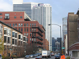
The Fulton River District is a Chicago neighborhood located on the edge of the city's downtown, northwest of the Loop. The district is bounded by the Chicago River to the east, the Kennedy Expressway to the west, Ohio Street to the north and Madison Street to the south, making it part of the Near West Side and West Town community areas of Chicago in Cook County, Illinois, United States. Just across the expressway to the west is the Fulton Market District. Money magazine ranked the neighborhood as #4 best place to live in the United States in 2019.

Downtown Boston is the central business district of Boston, Massachusetts, United States. Boston was founded in 1630. The largest of the city's commercial districts, Downtown is the location of many corporate or regional headquarters; city, county, state and federal government facilities; and many of Boston's tourist attractions. Similar to other central business districts in the U.S., Downtown has recently undergone a transformation that included the construction of new condos and lofts, renovation of historic buildings, and arrival of new residents and businesses. It is represented in the Boston City Council by District 2's Ed Flynn.

Adair Park is a historic residential neighborhood located southwest of downtown Atlanta. It has the form of a left curly bracket, bordered by the MARTA north–south rail line on the northwest, the BeltLine trail on the southwest and Metropolitan Parkway on the east. Historically Adair Park also included the area from Metropolitan Parkway to McDaniel Street on the east, but the city now considers that area part of the Pittsburgh neighborhood.
West Midtown, also known as Westside, is a colloquial area, comprising many historical neighborhoods located in Atlanta, Georgia. Once largely industrial, West Midtown is now the location of urban lofts, art galleries, live music venues, retail and restaurants.
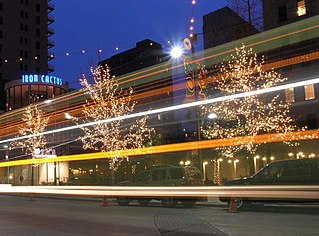
The 2nd Street Market is a public market in Dayton, Ohio. The market is located at the corner of Webster Street and East 2nd Street. It is Dayton's largest and oldest operating public market. In 2012, Country Living Magazine mentioned the market in its piece called “50 Things To Do This Summer in 50 States”. The market is owned and operated by Five Rivers MetroParks.
Marietta Street Artery is an officially defined neighborhood of the city of Atlanta, Georgia, part of the West Midtown area of Atlanta, also known as the "Westside."
Oakland is an officially recognized neighborhood of Atlanta consisting of only four blocks. It is bounded by:

Printers Row, also known as Printing House Row, is a neighborhood located in the south of the Chicago downtown area known as the Loop. The heart of Printers Row is generally defined by Ida B. Wells Drive on the north, Polk Street on the south, Plymouth Court on the east, and the Chicago River on the west. This neighborhood overlaps significantly with the officially designated landmark Printing House Row District to the north of Ida B Wells Drive and the South Loop Printing House District to the south of the Drive. The neighborhood includes Dearborn Station, which is also on the National Register of Historic Places.

Hartwell is one of the 52 neighborhoods of Cincinnati, Ohio. Established in 1868 and annexed in 1912, it is the city's northernmost neighborhood, centered roughly on the intersections of I-75 and Ronald Reagan Cross County Highway. Its boundaries are a combination of Caldwell Park and Ronald Reagan Cross County Highway to the south, I-75 to the east, and a combination of Millsdale Street and Compton Road to the North. The population was 5,806 at the 2020 census.
References
- ↑ Preserve Dayton Historict Neighborhoods
- ↑ "NEIGHBORHOOD GUIDE: Webster Station". dayton. Retrieved 2018-09-04.