Old North Dayton, Dayton, Ohio

Last updated
Old North Dayton, located north of downtown Dayton between the Great Miami and Mad Rivers, Ohio Old North Dayton.png
Old North Dayton, located north of downtown Dayton between the Great Miami and Mad Rivers, Ohio

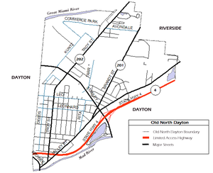
Old North Dayton is a neighborhood northeast of downtown Dayton, between the Great Miami and Mad rivers. Its main routes are Troy, Brandt, Valley, Stanley, Leo and Chapel Streets.

German immigrants were the first to settle in the neighborhood, then known as 'Texas' or 'Parma'. Around the turn of the 20th century, central European immigrants, predominantly Poles, Hungarians, Lithuanians and Germans, moved in as laborers and gave the neighborhoods its unique ethnic flavor represented by ethnic Roman Catholic churches, cultural festivals, social clubs, and a central European specialty restaurant, the Amber Rose. [1] In the 2010s, the neighborhood became home to hundreds of resettled Turkish immigrants. [2] [3]

Points of interest in the neighborhoods include the Amber Rose, Our Lady of the Rosary Catholic Church (German), St. Adalbert's Catholic Church (Polish) - closed, St. Stephen's Catholic Church (Hungarian) - closed, Holy Cross Catholic Church (Lithuanian), and the historic Kossuth Colony. The main campus of the Dayton Children's Hospital as well as Ronald McDonald House Charities Dayton are also in Old North Dayton.

The neighborhood is home to the Stuart Patterson Park. Formerly known as Walters Grove, the park was renamed in honor of Stuart Patterson, the nephew of John H. Patterson, who died in a plane crash at nearby McCook Field. Stuart Patterson Park is home to the Francis Fitzsimmons Senior Citizens Center.

State Routes 201 (Valley and Brandt Streets) and 202 (Troy St.) provide access to downtown Dayton, Riverside, and Huber Heights. Ohio State Route 4 provides access to Interstate 75, Interstate 70, U.S. Route 35, and Interstate 675.

On May 27, 2019, the neighborhood suffered significant losses from an EF4 tornado, the worst of a series which affected the greater Miami Valley. Multiple homes and businesses were a complete loss, with areas of the neighborhood losing power and water for several days. [4]

Related Research Articles

<span class="mw-page-title-main">Dayton, Ohio</span> City in Ohio, United States

Dayton is a city in Montgomery and Greene counties and the county seat of Montgomery County, Ohio, United States. As of the 2020 census, the city proper had a population of 137,644, making it the sixth-most populous city in Ohio. It anchors the state's fourth-largest metropolitan area, the Dayton metropolitan area, which had 814,049 residents. Dayton is located within Ohio's Miami Valley region, 50 miles (80 km) north of Cincinnati and 60 miles (97 km) west of Columbus.

<span class="mw-page-title-main">Montgomery County, Ohio</span> County in Ohio, United States

Montgomery County is in the southwestern part of the U.S. state of Ohio. At the 2020 census, the population was 537,309, making it the fifth-most populous county in Ohio. The county seat is Dayton. The county was named in honor of Richard Montgomery, an American Revolutionary War general, who was killed in 1775 while attempting to capture Quebec City, Canada. Montgomery County is part of the Dayton, Ohio, Metropolitan Statistical Area.

<span class="mw-page-title-main">Interstate 75</span> Interstate Highway from Michigan to Florida

Interstate 75 (I-75) is a major north–south Interstate Highway in the Great Lakes and Southeastern regions of the United States. As with most Interstates that end in 5, it is a major cross-country, north–south route, traveling from State Road 826 and SR 924 on the Hialeah–Miami Lakes border to Sault Ste. Marie, Michigan, at the Canadian border. It is the second-longest north–south Interstate Highway and the seventh-longest Interstate Highway overall.

<span class="mw-page-title-main">Tipp City, Ohio</span> City in Ohio, United States

Tipp City is a city in southern Miami County, Ohio, United States, just outside Dayton. The population was 10,274 at the 2020 census. Originally known as Tippecanoe, and then Tippecanoe City, it was renamed to Tipp City in 1938 because another town in Ohio was likewise named Tippecanoe. The city lies in the Miami Valley and sits along Interstate 75 near the Interstate 70 interchange. Tipp City is part of the Dayton metropolitan area.

<span class="mw-page-title-main">Miami Valley</span> Term for the Dayton metropolitan area

The Miami Valley is the land area surrounding the Great Miami River in southwest Ohio, USA, and includes the Little Miami, Mad, and Stillwater rivers as well. Geographically, it includes Dayton, Springfield, Middletown, Hamilton, and other communities. The name is derived from the Miami Indians.

<span class="mw-page-title-main">Cincinnati, Lebanon and Northern Railway</span> Ohio railroad (1885–1926)

The Cincinnati, Lebanon and Northern Railway (CL&N) was a local passenger and freight-carrying railroad in the southwestern part of the U.S. state of Ohio, connecting Cincinnati to Dayton via Lebanon. It was built in the late 19th century to give the town of Lebanon and Warren County better transportation facilities. The railroad was locally known as the "Highland Route", since it followed the ridge between the Little and Great Miami rivers, and was the only line not affected by floods such as the Great Dayton Flood of 1913.

<span class="mw-page-title-main">Canton, Baltimore</span> Neighborhood of Baltimore in Maryland, United States

Canton is a historic waterfront neighborhood in Baltimore, Maryland, United States. The neighborhood is along Baltimore's outer harbor in the southeastern section of the city, roughly 2 miles (3 km) east of Baltimore's downtown district and next to or near the neighborhoods of Patterson Park, Fell's Point, Highlandtown, and Brewers Hill.

<span class="mw-page-title-main">Ohio State Route 4</span> State highway in Ohio, US

State Route 4, formerly known as Inter-county Highway 4 until 1921 and State Highway 4 in 1922, is a major north–south state highway in Ohio. It is the fifth longest state route in Ohio. Its southern terminus is at U.S. Route 42 in Cincinnati, Ohio, and its northern terminus is at U.S. Route 6 in Sandusky, Ohio. Its path is nearly ruler-straight for many miles. Some portions of the route are still marked as Dixie Highway. The northern portion was constructed by the Columbus and Sandusky Turnpike Company, see Turnpike Lands.

<span class="mw-page-title-main">University of Dayton Ghetto</span> Human settlement in Dayton, Ohio, United States of America

The University of Dayton Student Neighborhood, located in Dayton, Ohio, is home to upperclassmen at the University of Dayton (UD). Formerly known as "the Ghetto," the UD Student Neighborhood is leased in an arrangement that resembles both traditional university housing and a landlord/tenant relationship. Tracing its history back to the 1870s, the neighborhood now includes more than 200 university-owned houses as well as landlord-owned houses, high-density housing and gathering spaces. With the inclusion of Holy Angels and The Darkside, or officially "the North Student Neighborhood", two smaller neighborhoods the university owns property in, there are more than 400 houses currently used as student residential space. Because of the area's age, the university has been engaged in a program to renovate and update the houses, and several additional changes to the neighborhood are expected in the coming years as part of the university's Master Plan.

Strawberry Hill is a historic neighborhood in Kansas City, Kansas, United States. It is bordered by Minnesota Avenue to its north, by Interstate 70 to its east and south, and by 7th Street to its west.

<span class="mw-page-title-main">Ukrainian Village, Chicago</span> Neighborhood in Chicago, Illinois

Ukrainian Village is a Chicago neighborhood located on the near west side of Chicago. Its boundaries are Division Street to the north, Grand Avenue to the south, Western Avenue to the west, and Damen Avenue to the east. It is one of the neighborhoods in the West Town community area, and has one of the largest concentrations of Ukrainians in the United States.

<span class="mw-page-title-main">Brickell</span> Neighborhood of Miami in Miami-Dade County, Florida, United States

Brickell is a neighborhood in Miami, Florida, historically referenced at times as "Southside", located directly east of Interstate 95, south of the Miami River, and north of Coconut Grove. Brickell is known as the financial district of Miami, as well as South Florida.

<span class="mw-page-title-main">McPherson Town Historic District</span> Historic district in Ohio, United States

The McPherson Town Historic District of Dayton, Ohio, contains roughly 90 structures north of downtown Dayton, across the Great Miami River.

Columbus, the state capital and Ohio's largest city, has numerous neighborhoods within its city limits. Neighborhood names and boundaries are not officially defined. They may vary or change from time to time due to demographic and economic variables.

<span class="mw-page-title-main">Otterbein, Baltimore</span> Neighborhood of Baltimore in Maryland, United States

Otterbein is a small neighborhood of historic rowhouses in Baltimore, Maryland, United States. Otterbein is immediately southwest of, and in close walking distance to, the Inner Harbor. The neighborhood is very compact, entirely located between Hanover Street and Sharp Street, and between Barre Street and Henrietta Street. It is in small parts of zip codes 21201 and 21230. It is named for Old Otterbein Church, located immediately north of the neighborhood.

<span class="mw-page-title-main">Interstate 75 in Ohio</span> Interstate Highway in Ohio, United States

Interstate 75 (I-75) runs from Cincinnati to Toledo by way of Dayton in the US state of Ohio. The highway enters the state running concurrently with I-71 from Kentucky on the Brent Spence Bridge over the Ohio River and into the Bluegrass region. I-75 continues along the Mill Creek Expressway northward to the Butler County line just north of I-275. From there, the freeway runs into the Miami Valley and then passes through the Great Black Swamp before crossing into Michigan.

<span class="mw-page-title-main">Ohio State Route 202</span> State highway in western Ohio, US

State Route 202 (SR 202) is a 20-mile (32 km) north–south state highway in the western part of the U.S. state of Ohio. The highway runs from its southern terminus at an intersection with SR 201 in Dayton to its northern terminus at a T-intersection with SR 55 in the eastern end of Troy.

<span class="mw-page-title-main">Dayton metropolitan area</span> Metropolitan Statistical Area in Ohio, United States

Greater Dayton or the Miami Valley, or more formally the Dayton–Kettering–Beavercreek, OH Metropolitan Statistical Area, as defined by the United States Census Bureau, is an area consisting of three counties in the Miami Valley region of Ohio and is anchored by the city of Dayton. As of 2020, it is the fourth-largest metropolitan area in Ohio and the 73rd-largest metropolitan area by population in the United States with a population of 814,049.

<span class="mw-page-title-main">Ohio State Route 201</span> State highway in western Ohio, US

State Route 201 (SR 201) is a 21.69-mile (34.91 km) long north–south state highway in the western portion of the U.S. state of Ohio. The southern terminus of SR 201 is at an interchange with the SR 4 freeway in Dayton. Its northern terminus is at a T-intersection with SR 55 approximately 3.25 miles (5.23 km) east of Casstown.

<span class="mw-page-title-main">Cincinnati metropolitan area</span> Metropolitan Statistical Area in the United States

The Cincinnati metropolitan area is a metropolitan area with its core in Ohio and Kentucky. Its largest city is Cincinnati and includes surrounding counties in the U.S. states of Ohio, Kentucky, and Indiana.

References

  1. Wilde, Renee (April 7, 2016). "What Happened To Hung-Town? WYSO Curious Goes In Search Of Hungarian Dayton". WYSO. Retrieved April 4, 2020.
  2. Gottschlich, Anthony (June 18, 2010). "In Old North Dayton, Turkish refugees find home, new way of life". Dayton Daily News. Retrieved April 4, 2020.
  3. "Old North Dayton celebrates opening of Ahiska Turkish mosque". WHIO. April 23, 2018. Retrieved April 4, 2020.
  4. Laissle, April (May 31, 2019). "Clean Up Efforts Begin in Old North Dayton". WYSO.org. Retrieved May 31, 2019.

39°47′N84°10′W / 39.79°N 84.17°W / 39.79; -84.17