
Ambergris Caye, is the largest island of Belize, located northeast of the country's mainland, in the Caribbean Sea. It is about 40 kilometres (25 mi) long from north to south, and about 1.6 kilometres (1 mi) wide. Many parts of the island have been modified by human development since the arrival of coconut plantations in the 17th century, but it remains largely white coral sand with mangrove forest at its center. Its eastern coast runs parallel to the northernmost stretch of the Belize Barrier Reef, a UNESCO World Heritage Site.
An artificial reef (AR) is a human-created freshwater or marine benthic structure. Typically built in areas with a generally featureless bottom to promote marine life, it may be intended to control erosion, protect coastal areas, block ship passage, block the use of trawling nets, support reef restoration, improve aquaculture, or enhance scuba diving and surfing. Early artificial reefs were built by the Persians and the Romans.

The Florida Keys National Marine Sanctuary is a U.S. National Marine Sanctuary in the Florida Keys. It includes the Florida Reef, the only barrier coral reef in North America and the third-largest coral barrier reef in the world. It also has extensive mangrove forest and seagrass fields. The Florida Keys National Marine Sanctuary, designated in 1990, is the ninth national marine sanctuary to be established in a system that comprises 13 sanctuaries and two marine national monuments. The Florida Keys National Marine Sanctuary protects approximately 2,900 square nautical miles of coastal and ocean waters from the estuarine waters of south Florida along the Florida Keys archipelago, encompassing more than 1,700 islands, out to the Dry Tortugas National Park, reaching into the Atlantic Ocean, Florida Bay and the Gulf of Mexico.

Caye Caulker is a small limestone coral island off the coast of Belize in the Caribbean Sea measuring about 5 miles (8.0 km) by less than 1 mile (1.6 km). The town on the island is known by the name Caye Caulker Village. The population of Caye Caulker is approximately 2,000 people today and still growing.
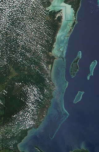
The Belize Barrier Reef is a series of coral reefs straddling the coast of Belize, roughly 300 metres (980 ft) offshore in the north and 40 kilometres (25 mi) in the south within the country limits. The Belize Barrier Reef is a 300-kilometre (190 mi) long section of the 900-kilometre (560 mi) Mesoamerican Barrier Reef System, which is continuous from Cancún on the north-eastern tip of the Yucatán Peninsula through the Riviera Maya and down to Honduras, making it the second largest coral reef system in the world after the Great Barrier Reef in Australia. It is Belize's top tourist destination, popular for scuba diving and snorkeling and attracting almost half of its 260,000 visitors. It is also vital to the country's fishing industry.
Reef Ball Foundation, Inc. is a 501(c)(3) non-profit organization that functions as an international environmental non-governmental organization. The foundation uses reef ball artificial reef technology, combined with coral propagation, transplant technology, public education, and community training to build, restore and protect coral reefs. The foundation has established "reef ball reefs" in 59 countries. Over 550,000 reef balls have been deployed in more than 4,000 projects.

Hol Chan Marine Reserve is a marine reserve close to Ambergris Caye and Caye Caulker, off the coast of Belize. It covers approximately 18 km² (4,448 acres) of coral reefs, seagrass beds, and mangrove forest. Hol Chan is Mayan for "little channel".
Since declaring independence in 1981, Belize has enacted many environmental protection laws aimed at the preservation of the country's natural and cultural heritage, as well as its wealth of natural resources. These acts have established a number of different types of protected areas, with each category having its own set of regulations dictating public access, resource extraction, land use and ownership.
The Congal Biomarine Station is a protected nature reserve created in 2000 and is located in southwestern Esmeraldas Province, close to the town of Muisne in northwestern Ecuador. The Congal Reserve is managed by the Jatun Sacha Foundation and features beach, estuarine, mangrove, wetlands and humid tropical forest habitats, accounting for the region's high biodiversity and local endemism. The station was founded by the Quiroga family in partnership with conservationist, Arlo Hemphill.
The Caribbean Coral Reef Ecosystems (CCRE) program began with a collaborative field project conceived by six National Museum of Natural History scientists during the early 1970s. The scientists interests included a range of disciplines central to reef ecology, including: invertebrate and vertebrate zoology, botany, carbonate geology, and paleobiology. The primary work site is the Carrie Bow Marine Field Station, a research station at Carrie Bow Caye on the Meso-American Barrier Reef in Belize. The program is an extended duration study of coral reefs, mangroves, sea grass meadows, and the sandy bottoms. It has been a functioning research program since the early 1970s when it was called the Investigations of Marine Shallow-Water Ecosystems (IMSWE).

The Liquid Jungle Lab (LJL) is a tropical marine research station on the island of Canales de Tierra on the western coast of Pacific Panamá along a primary marine biological corridor. The LJL research campus was completed in 2004 and is part of a private 3,500 hectare reserve composed of primary forest, mangroves, tide pools, and a rocky inter-tidal zone that transitions into fringing coral reefs.

Earthwatch Institute is an international environmental charity. It was founded in 1971 as Educational Expeditions International by Bob Citron and Clarence Truesdale. Earthwatch Institute supports Ph.D. researchers internationally and conducts over 100,000 hours of research annually using the Citizen Science methodology. Earthwatch's mission statement states that the organization "connects people with scientists worldwide to conduct environmental research and empowers them with the knowledge they need to conserve the planet." As such, it is one of the global underwriters of scientific field research in climate change, archaeology, paleontology, marine life, biodiversity, ecosystems and wildlife. For over fifty years, Earthwatch has raised funds to recruit individuals, students, teachers, and corporate fellows to participate in field research to understand nature's response to accelerating global change.
Bacalar Chico National Park and Marine Reserve (BCNPMR) is a protected area and UNESCO World Heritage Site on the northern part of Ambergris Caye in Belize.
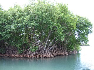
Mangrove ecosystems represent natural capital capable of producing a wide range of goods and services for coastal environments and communities and society as a whole. Some of these outputs, such as timber, are freely exchanged in formal markets. Value is determined in these markets through exchange and quantified in terms of price. Mangroves are important for aquatic life and home for many species of fish.

A marine habitat is a habitat that supports marine life. Marine life depends in some way on the saltwater that is in the sea. A habitat is an ecological or environmental area inhabited by one or more living species. The marine environment supports many kinds of these habitats.

Half Moon Caye is an island and natural monument of Belize located at the southeast corner of Lighthouse Reef Atoll. This natural monument was the first nature reserve to have been established in Belize under the National Park Systems Act in 1981 and first marine protected area in Central America. This is also Belize's oldest site of wildlife protection since it was first designated as a bird sanctuary in 1924 to protect the habitat of the red-footed booby birds.

Salt ponds are a natural feature of both temperate and tropical coastlines. These ponds form a vital buffer zone between terrestrial and marine ecosystems. Contaminants such as sediment, nitrates and phosphates are filtered out by salt ponds before they can reach the ocean. The depth, salinity and overall chemistry of these dynamic salt ponds fluctuate depending on temperature, rainfall, and anthropogenic influences such as nutrient runoff. The flora and fauna of tropical salt ponds differ markedly from those of temperate ponds. Mangrove trees are the dominant vegetation of tropical salt pond ecosystems, which also serve as vital feeding and breeding grounds for shore birds.

Turneffe Atoll is located southeast of Ambergris Caye and Caye Caulker, off the coast of Belize in Central America, 20 miles from Belize City. It is one of three atolls of the Belize Barrier Reef, along with Glover's Reef and Lighthouse Reef. It is approximately 30 miles long and 10 miles wide, making it the largest coral atoll in Belize and in the Mesoamerican Barrier Reef System. The atoll was officially declared a marine reserve on November 22, 2012.
The St. Croix East End Marine Park (STXEEMP) was established to "protect territorially significant marine resources, and promote sustainability of marine ecosystems, including coral reefs, sea grass beds, wildlife habitats and other resources, and to conserve and preserve significant natural areas for the use and benefit of future generations." It is the U.S. Virgin Islands’ first territorially designated and managed marine protected area (MPA).

The Belizean reef mangroves ecoregion covers the mangrove habitats along the islands and cayes of the Belize Barrier Reef. This ecoregion is distinct from the mainland Belizean Coast mangroves ecoregion, and may be considered a sub-unit of the overall Mesoamerican Gulf-Caribbean mangroves ecoregion.

