
Weena is a street with many highrises in the center of Rotterdam, Netherlands. [1] It defines the Rotterdam skyline. [2] The street of about 1 kilometer length leads east-west from Hofplein to Beukelsdijk.
Weena is a street with many highrises in the center of Rotterdam, Netherlands. [1] It defines the Rotterdam skyline. [2] The street of about 1 kilometer length leads east-west from Hofplein to Beukelsdijk.

Weena was named after the Hof van Wena, a 12th-century keep which stood at the site of the former Hofplein Station. The building was destroyed in 1426. [3] The name remained in use to designate the area just outside Hofpoort, the northern city gate.
In 1854 the names Weenastraat and Weenaplein were given to an existing street and square in the area, following city architect Willem Nicolaas Rose´s design. After the bombing of Rotterdam in 1940 the area was demolished.
In 1949 the city government gave the name Weena to a street through the still wide open terrain. The construction of the Groothandelsgebouw (1953), Rotterdam Centraal Station (1957) and the Hilton Rotterdam (1963) transformed Weena into an icon of the postwar reconstruction of the city. [1] Major new developments followed in the 1990s and in the early 21st century.
In 2007 Weena was named the most air-polluted street in the Netherlands. [4]


Rotterdam is the second-largest city in the Netherlands after the national capital of Amsterdam. It is in the province of South Holland, part of the North Sea mouth of the Rhine–Meuse–Scheldt delta, via the "New Meuse" inland shipping channel, dug to connect to the Meuse at first and now to the Rhine.

Utrecht is the fourth-largest city of the Netherlands, as well as the capital and the most populous city of the province of Utrecht. The municipality of Utrecht is located in the eastern part of the Randstad conurbation, in the very centre of mainland Netherlands, and includes Haarzuilens, Vleuten en De Meern. It has a population of 361,699 as of December 2021.
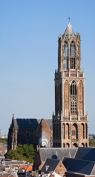
The Dom Tower of Utrecht is the tallest church tower in the Netherlands, at 112.32 metres (368,5 feet) in height. It is considered the symbol of Utrecht. The tower was part of St. Martin's Cathedral, also known as the Dom Church, and was built between 1321 and 1382, to a design by John of Hainaut. The cathedral was never fully completed due to lack of money. Since the unfinished nave collapsed in 1674, the Dom tower has been a freestanding tower. The tower stands at the spot where the city of Utrecht originated almost 2,000 years ago.

Amersfoort is a city and municipality in the province of Utrecht, Netherlands. As of 31 January 2023, the municipality had a population of 160,902, making it the second-largest of the province and fifteenth-largest of the country. Amersfoort is also one of the largest Dutch railway junctions with its three stations—Amersfoort Centraal, Schothorst and Vathorst—due to its location on two of the Netherlands' main east to west and north to south railway lines. The city was used during the 1928 Summer Olympics as a venue for the modern pentathlon events. Amersfoort marked its 750th anniversary as a city in 2009.

Hoofddorp is the main town of the municipality of Haarlemmermeer, in the province of North Holland, the Netherlands. In 2021, the population was 77,885. The town was founded in 1853, immediately after the Haarlemmermeer had been drained.

Haarlem railway station is located in Haarlem in North Holland, Netherlands. The station opened at September 20, 1839, on the Amsterdam–Rotterdam railway, the first railway line in the Netherlands. The station building itself is a rijksmonument.

Stadion Feijenoord, more commonly known by its nickname De Kuip, is a stadium in Rotterdam, Netherlands. It was completed in 1937. The name is derived from the Feijenoord district in Rotterdam, and from the club with the same name.
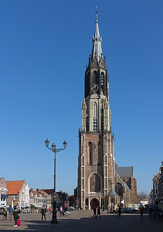
The Nieuwe Kerk is a Protestant church in the city of Delft in the Netherlands. The building is located on Delft Market Square (Markt), opposite to the City Hall. In 1584, William the Silent was entombed here in a mausoleum designed by Hendrick and Pieter de Keyser. Since then members of the House of Orange-Nassau have been entombed in the royal crypt. The latest are Queen Juliana and her husband Prince Bernhard in 2004. The private royal family crypt is not open to the public. The church tower, with the most recent recreation of the spire which was designed by Pierre Cuypers and completed in 1872, is the second highest in the Netherlands, after the Domtoren in Utrecht.

Amsterdam Centraal station is the largest railway station in Amsterdam, North Holland, the Netherlands. A major international railway hub, it is used by 192,000 passengers a day, making it the second busiest railway station in the country after Utrecht Centraal and the most visited Rijksmonument of the Netherlands.
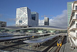
Utrecht Centraal, officially Station Utrecht Centraal, is the transit hub that integrates three bicycle parkings, two bus stations, two tram stops and the central railway station for Utrecht, Netherlands. It is the biggest train station in the Netherlands.

Den Haag Laan van NOI railway station is a railway station in the Netherlands, on the border between The Hague and the town of Voorburg. It is served by the Nederlandse Spoorwegen and by the RandstadRail light-rail network. The station is named after the road on which it is located, Laan van Nieuw Oost-Indië, which literally translates as New East Indies Avenue, but probably refers to a former inn called Nieuw Oosteinde.

Rotterdam Centraal station is the main railway station of the city Rotterdam in South Holland, Netherlands. The station received an average of 112,000 passengers daily in 2019. The current station building, located at Station Square, was officially opened in March 2014.

Delftse Poort is a twin-tower skyscraper complex at Weena 505 next to the Rotterdam Centraal railway station in Rotterdam, Netherlands. Tower I is 151.35 m (496.6 ft) with 41 stories, and Tower II is 93 m (305 ft) with 25 stories. Until May 2009, Tower I was the tallest office tower in the Netherlands. Both towers are built over a 4-storey multifunctional podium which adjoins the Rotterdam central station. The entire complex has 28 elevators. The gross floor area in the complex is 106,000 m2 (1,140,000 sq ft), and the offices occupy 66,000 m2 (710,000 sq ft).

The Groothandelsgebouw is an extensive building and monument in the center of Rotterdam, Netherlands next to the Central Station of the city. Completed in 1953 it is one of the first major buildings built after the bombing of Rotterdam in the Second World War.

A bicycle parking station, or bicycle garage, is a building or structure designed for use as a bicycle parking facility. Such a facility can be as simple as a lockable bike cage or shed or as complex as a purpose-built multi-level building: the common purpose is that they provide secure bicycle parking. Bicycle parking stations also go by names such as bike stations, bicycle centers and cycle centers, among many others.
Rotterdam Hofplein railway station in the Netherlands is a former main-line and RandstadRail station. It was the terminus of the former Hofpleinlijn which ran trains between Rotterdam and Scheveningen, and were later curtailed to The Hague central station. It was located very close to the railway line between Rotterdam Centraal and Rotterdam Blaak, but never had a direct connection to it.

Noordereiland is a neighborhood of Rotterdam, Netherlands. The Noordereiland owes its name to the Noorderhaven which, under the leadership of C.B. van der Tak was dug between 1872 and 1874. By digging the Noorderhaven, the Noordereiland was separated from the former island of Fijenoord and is now an island between the central parts of the North and South side of the city. Until the end of the 20th century the island was inhabited by a large population of inland skippers. Part of the neighborhood is a protected cityscape.
The following is a timeline of the history of the municipality of Rotterdam, Netherlands.

51°55′23″N4°28′13″E / 51.9230°N 4.4704°E
| | This South Holland location article is a stub. You can help Wikipedia by expanding it. |