
The Meuse or Maas is a major European river, rising in France and flowing through Belgium and the Netherlands before draining into the North Sea from the Rhine–Meuse–Scheldt delta. It has a total length of 925 km.

The Scheldt is a 350-kilometre-long (220 mi) river that flows through northern France, western Belgium, and the southwestern part of the Netherlands, with its mouth at the North Sea. Its name is derived from an adjective corresponding to Old English sceald ("shallow"), Modern English shoal, Low German schol, West Frisian skol, and Swedish (obsolete) skäll ("thin").

Grimbergen is a municipality in the Belgian province of Flemish Brabant, 10 km north of the capital Brussels. It comprises the towns of Beigem, Grimbergen, Humbeek and Strombeek-Bever. In 2017, it had a population of 37,030 and an area of 38.61 km2, giving a population density of 959 inhabitants per km2.
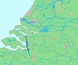
The Scheldt–Rhine Canal (Schelde-Rijnkanaal) in Belgium and the Netherlands connects Antwerp with the Volkerak, and thereby the Scheldt with the Rhine.
The Pajottenland is a distinct region within the Flemish Brabant province of Belgium. The region is located west-southwest of Brussels. The Pajottenland is predominantly farmland, with occasional gently rolling hills, and lies mostly between the rivers Dender and Zenne / Senne. The area has historically provided food and drink for the citizens of Brussels, especially Lambic beers, which are only produced here and in the Zenne valley where Brussels is.

The Duchy of Limburg or Limbourg was an imperial estate of the Holy Roman Empire. Much of the area of the duchy is today located within Liège Province of Belgium, with a small portion in the municipality of Voeren, an exclave of the neighbouring Limburg Province. Its chief town was Limbourg-sur-Vesdre, in today's Liège Province.
Koninklijke Voetbal Vereniging Crossing Elewijt is a Belgian association football club from the village of Elewijt in the municipality of Zemst, Flemish Brabant. It plays at the eighth level in the Belgian football league system, i.e. in the 3rd division of the regional league of Brabant as of 2014–15.

The Duchy of Brabant was a State of the Holy Roman Empire established in 1183. It developed from the Landgraviate of Brabant and formed the heart of the historic Low Countries, part of the Burgundian Netherlands from 1430 and of the Habsburg Netherlands from 1482, until it was partitioned after the Dutch revolt.
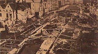
The covering of the Senne was the covering and later diverting of the main river of Brussels, and the construction of public buildings and major boulevards in its place. Carried out between 1867 and 1871, it is one of the defining events in the history of Brussels.

The Brussels–Scheldt Maritime Canal, is a canal in Belgium linking Brussels with the Scheldt river and ultimately the sea. The 28 km long canal has a width of 30 m. and a draught of 2 m., and connects the cities of Brussels and Willebroek, where it joins the Rupel river in the hamlet of Klein-Willebroek. Hence previously the canal was officially known as the Brussels-Rupel Maritime Canal prior to the establishment of a direct link with the Scheldt in 1997.

Eppegem is a village in the municipality of Zemst, Flemish Brabant, Belgium.
The Zenne Group is a group of rock strata in the subsurface of central and northwest Belgium. The group consists of three formations, all from the Ypresian and Lutetian ages. These formation have their shallow marine facies in common.
The Lede Formation is a geologic formation in the subsurface of Belgium. The formation is named after the town of Lede in East Flanders. It consists of shallow-marine limestone and sandstone, deposited in the former sea that covered Belgium during the Eocene.
Hofstade is a village in the municipality of Zemst, Flemish Brabant, Belgium.

The Belgian railway line 25 is the oldest railway line in Belgium. It connects the main two cities in Belgium: Brussels and Antwerp. The section between Brussels and Mechelen was completed in on May 5, 1835 and was the first railroad in Belgium. On May 3, 1836, the second section was opened. It was extended to Luchtbal in the north of Antwerp in 2007 in order to shorten the route from Amsterdam to Brussels. The total line runs 47.6 km.
Zemst-Laar or Laar is a village in Flemish Brabant, Belgium. It is part of the municipality of Zemst.
Elewijt is a village in the municipality of Zemst, Flemish Brabant, Belgium.

Heindonk is a Belgian village in the municipality of Willebroek in the province of Antwerp in Belgium. It is situated northwest of the city of Mechelen.
Zemst-Bos is a village in Flemish Brabant, Belgium. It is part of the municipality of Zemst and has about 1,000 inhabitants.
Het Zwartland is a hamlet of the village Zemst-Bos, in Flemish Brabant, Belgium. It is part of the municipality of Zemst. It has a size of 70 hectares and has 47 inhabitants.

