
The Zuiderzee or Zuider Zee was a shallow bay of the North Sea in the northwest of the Netherlands, extending about 100 km inland and at most 50 km wide, with an overall depth of about 4 to 5 metres (13–16 feet) and a coastline of about 300 km. It covered 5,000 km2 (1,900 sq mi). Its name is Dutch for "southern sea", indicating that the name originates in Friesland, to the north of the Zuiderzee. In the 20th century the majority of the Zuiderzee was closed off from the North Sea by the construction of the Afsluitdijk, leaving the mouth of the inlet to become part of the Wadden Sea. The salt water inlet changed into a fresh water lake now called the IJsselmeer after the river that drains into it, and by means of drainage and polders, an area of some 1,500 km2 (580 sq mi) was reclaimed as land. This land eventually became the province of Flevoland, with a population of nearly 400,000 (2011).

North Holland is a province of the Netherlands in the northwestern part of the country. It is located on the North Sea, north of South Holland and Utrecht, and west of Friesland and Flevoland. In November 2019, it had a population of 2,877,909 and a total area of 4,092 km2 (1,580 sq mi), of which 1,430 km2 (550 sq mi) is water.

Hoofddorp is the main town of the Haarlemmermeer municipality in the province of North Holland in the Netherlands. In 2021, the population was 77,885. The town was founded in 1853, immediately after the Haarlemmermeer had been drained.

Nootdorp is a small town and suburb in the Dutch province of South Holland. It is bordered by Zoetermeer to the north, by The Hague to the west, by Delfgauw to the south and by Pijnacker to the east. Nootdorp was a separate municipality until 2002, when it merged with Pijnacker to form Pijnacker-Nootdorp, which is a part of Greater The Hague.

Oud-Zuid is the name of a neighbourhood and of a (larger) former borough (stadsdeel) of Amsterdam.

Jutphaas is a former village and municipality in the province of Utrecht in the Netherlands. The municipality merged with Vreeswijk in 1971, and is now the northern half of the town of Nieuwegein.

Oud-Wulven is a hamlet in the Dutch province of Utrecht. It is located just north of the village of Houten, and is part of that municipality.

Ransdorp is a village in the province of North Holland, Netherlands, part of the municipality of Amsterdam. It lies about 7 km northeast of the city centre, in the Landelijk Noord district. Ransdorp is a part of the borough Amsterdam-Noord and has about 245 inhabitants.

FC Blauw-Wit Amsterdam was a Dutch football club from Amsterdam. The name referred to the colours of their uniform, blue and white.
Sterkenburg is a hamlet and former municipality in the Dutch province of Utrecht. It existed between 1818 and 1857, when it was merged with Driebergen.

The Battle on the Zuiderzee was a naval battle during the Eighty Years' War in which a Dutch fleet destroyed a larger and better-equipped Spanish fleet on the Zuiderzee.

Amsterdam-Noord is a borough of Amsterdam, Netherlands with a population of about 90,000. The IJ, the body of water which separates it from Amsterdam-Centrum and the rest of the city, is situated southwest of Amsterdam-Noord. The borough, which has an area of 49.01 km2, borders the municipalities of Zaanstad, Oostzaan, Landsmeer and Waterland to the north, all part of the province of North Holland like Amsterdam. It borders the Markermeer to the east.
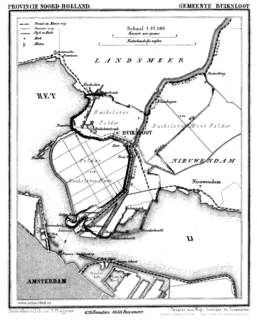
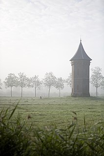
Buiksloot is a former village in the Dutch province of North Holland. It is now a neighbourhood of Amsterdam-Noord.
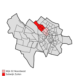
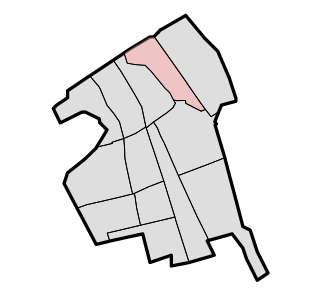
Zuilen is a district in the Northwest section of the Dutch city of Utrecht.

Alexandria or Fort Alexandria is a National Historic Site of Canada on the Fraser River in British Columbia, and was the end of the Old Cariboo Road and the Cariboo Wagon Road. It is located on Highway 97, 103 miles (166 km) north of 100 Mile House and 28 miles (45 km) south of Quesnel.
Vrijenban is a neighborhood of Delft in the Netherlands province of South Holland. It is located on the northeast boundary of the historic city center of Delft. Prior to being merged into Delft, Vrijenban used to be a municipality in its own right.
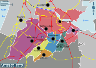
Amstelland is the area along the river Amstel in the Netherlands, beginning in South Holland and running north towards Amsterdam in southern North Holland.

Osdorp is neighbourhood of Amsterdam, Netherlands. A larger area was, from 1981 until 2010, a stadsdeel (borough) of Amsterdam and in 2010 was merged into the new borough of Amsterdam Nieuw-West.
Bos en Lommer is a neighborhood of Amsterdam, Netherlands. From 1990 to 2010 it was considered a district of the municipality of Amsterdam in the province of North Holland. As of May 1, 2010, it was merged into the new Amsterdam-West borough.

