Wehntal

Last updated

Wehntal is the name of a valley region in the Canton of Zürich in Switzerland.

Canton of Zürich Canton of Switzerland

The canton of Zürich is a Swiss canton in the northeastern part of the country. With a population of 1,504,346, it is the most populated canton in the country.. Its capital is the city of Zürich. The official language is German. The local Swiss German dialect, called Züritüütsch, is commonly spoken. In English the name of the canton and its capital is often written without an umlaut.

Contents

Wehntal at Niederweningen Niederweningen - Lagern Burghorn 20100524 16-26-52.JPG
Wehntal at Niederweningen
Wehntal at Oberweningen and Schleinikon Oberweningen - Schleinikon Grosszelg 2011-09-14 14-04-10.JPG
Wehntal at Oberweningen and Schleinikon
Dielsdorf and western Glatttal as seen from the Regensberg Castle Dielsdorf - Regensberg Unterburg 20100524 18-51-18.JPG
Dielsdorf and western Glatttal as seen from the Regensberg Castle

Geography

The Wehn valley (native German name: Wehntal) area is situated between the Lägern and Egg mountain chain in the Dielsdorf District of the Canton of Zürich in Switzerland. To the east the valley is bounded by a moraine of the Linth glacier, respectively the lower Glatt Valley near Dielsdorf, and in the west it passes over to the border of the Canton of Aargau respectively the drainage bassin of the Surb Valley (native German name: Surbtal) and the river of the same name which rises in the Wehntal. The population of the region is expanding rapidly due to its proximity to city of Zürich and its beautiful landscape.

Lägern mountain of Switzerland

The Lägern is a wooded mountain of the Jura Mountains, stretching from Baden to Dielsdorf, about 15 km north-west of Zurich. The culminating point is located 1 km west of Hochwacht within the canton of Zurich, the border with the canton of Aargau running on a slightly lower summit named Burghorn.

Dielsdorf District is a district in the northwestern part of the Swiss canton of Zürich.

Moraine Glacially formed accumulation of unconsolidated debris

A moraine is any glacially formed accumulation of unconsolidated glacial debris that occurs in both currently and formerly glaciated regions on Earth, through geomorphological processes. Moraines are formed from debris previously carried along by a glacier and normally consisting of somewhat rounded particles ranging in size from large boulders to minute glacial flour. Lateral moraines are formed at the side of the ice flow and terminal moraines at the foot, marking the maximum advance of the glacier. Other types of moraine include ground moraines, till-covered areas with irregular topography, and medial moraines which are formed where two glaciers meet.

Wehntal comprises the area of the municipalities:

Schöfflisdorf Place in Zürich, Switzerland

Schöfflisdorf is a municipality in the district of Dielsdorf in the canton of Zürich in Switzerland.

Oberweningen Place in Zurich, Switzerland

Oberweningen is a municipality in the district of Dielsdorf in the canton of Zürich in Switzerland.

Schleinikon Place in Zurich, Switzerland

Schleinikon is a municipality in the district of Dielsdorf in the canton of Zürich in Switzerland.

History

About 185,000 years ago, a side lobe of the Walensee/Reinglacier overlapped on the threshold at the present Pfannenstiel eastern slope from Hombrechtikon into the Glatttal towards Niederweningen, and eroded the overdeepened rock rut of the present Wehntal area. During melting of the glacier, Wehntal, the lower Glatttal and Furttal filled about 180,000 to 150,000 years ago with cold glacial lakes. After another glacier maximum about 140,000 years ago, the ice melted in the last Eemian (interglacial) period back far into the alpine valleys, and great lakes with border union fens filled the former glacial basin. During the Würm glaciation and again about 45,000 years ago, mammoths and other Ice Age animals lived in the largely silted Wehntal. During the last glacial maximum about 24,000 years ago the glaciers pushed again to the lower Glatttal, but not to Wehntal. With the increasing warming period about 20,000 years ago, the glaciers melted away in stages to Zürich, later Hurden and formed the Seedamm at the Obersee lake shore respectively the Ufenau, Lützelau and Heilig Hüsli islands on Zürichsee, and finally the glaciers retreated into the alpine mountains. [1] [2]

Pfannenstiel (Zürich) mountain in the canton of Zürich in Switzerland

Pfannenstiel is a wooded mountain respectively a region overlooking the Lake Zürich and Zürcher Oberland in the canton of Zürich in Switzerland.

Hombrechtikon Place in Zurich, Switzerland

Hombrechtikon is a municipality in the district of Meilen in the canton of Zürich in Switzerland.

Eemian Interglacial period which began 130,000 years ago

The Eemian was the interglacial period which began about 130,000 years ago at the end of the Penultimate Glacial Period and ended about 115,000 years ago at the beginning of the Last Glacial Period. It corresponds to Marine Isotope Stage 5e. Although sometimes referred to as the "last interglacial", it was the second-to-latest interglacial period of the current Ice Age, the most recent being the Holocene which extends to the present day. The prevailing Eemian climate was, on average, around 1 to 2 degrees Celsius warmer than that of the Holocene. However, due to global warming, the past few July global temperatures likely surpassed the July temperatures of the Eemian period. During the Eemian, the proportion of CO
2
in the atmosphere was about 280 parts per million.

In 1890 the most important site of ice animals in Switzerland was discovered in Niederweningen. Particularly the uppermost deposits with the so-called Mammut turf layer were studied up in about 5 metres (16 ft) depth, and between 1983 and 1985 by three research boreholes to a depth of 21 metres (69 ft). In 1994 a groundwater bore in Oberweningen proved that the Wehntal area originally laid at least 130 metres (430 ft) deeper than the present valley floor and had to be caused by glacial erosion. In 2003 the remains of a Mammoth were found, and further finds resulted in the establishment of the present Mammutmuseum Niederweningen . [3] [1]

Niederweningen Place in Zurich, Switzerland

Niederweningen is a municipality in the district of Dielsdorf in the canton of Zürich in Switzerland.

Mammoth Extinct genus of mammals

A mammoth is any species of the extinct genus Mammuthus, one of the many genera that make up the order of trunked mammals called proboscideans. The various species of mammoth were commonly equipped with long, curved tusks and, in northern species, a covering of long hair. They lived from the Pliocene epoch into the Holocene at about 4,000 years ago, and various species existed in Africa, Europe, Asia, and North America. They were members of the family Elephantidae, which also contains the two genera of modern elephants and their ancestors.

Mammutmuseum Niederweningen Mammoth and geology museum in Im Mitteldorf , Niederweningen

The Mammutmuseum Niederweningen is a paleontological and geological museum in the municipality of Niederweningen in the Wehntal valley, Canton of Zürich, Switzerland, and one of the few mammoth museums in Europe.

2003 Mammoth find in Niederwenigen Mammutfund Niederweningen.jpg
2003 Mammoth find in Niederwenigen

Archaeological finds date back to the Roman era. The term Wehn may derived from the probably Allamanic name Waninc respectively Wano, meaning Wano's valley. [4] The heartland of the possessions of the medieval House of Regensberg was in the Furt and Wehn valleys besides the Lägern chain, where around 1050 AD the family built its ancestral seat Altburg near Zürich-Affoltern and two centuries later Neu-Regensberg on the eastern Lägern slope.

Furttal is the name of a valley region in Switzerland between Lägern and Altberg in the Dielsdorf district of the canton of Zurich.

Alt-Regensberg Castle

Alt-Regensberg Castle is a hill castle which was built about the mid-11th century AD by the House of Regensberg in the Swiss municipality of Regensdorf in the Canton of Zürich.

Transportation

The area is part of the S-Bahn Zürich on the line S15, and around the city of Zürich provided by Verkehrsbetriebe Zürich (VBZ), the public transport operator in the city of Zurich and its suburbs.

Literature

See also

Related Research Articles

Aletsch Glacier glacier in Switzerland

The Aletsch Glacier or Great Aletsch Glacier is the largest glacier in the Alps. It has a length of about 23 km (14 mi) (2014), has about a volume of 15.4 km3 (3.7 cu mi) (2011), and covers about 81.7 km2 (2011) in the eastern Bernese Alps in the Swiss canton of Valais. The Aletsch Glacier is composed of four smaller glaciers converging at Concordia Place, where its thickness was measured by the ETH to be still near 1 km (3,300 ft). It then continues towards the Rhône valley before giving birth to the Massa. The Aletsch Glacier is – like most glaciers on this world – a retreating glacier. As of 2016, since 1980 it lost 1.3 kilometres (0.81 mi) of its length, since 1870 3.2 kilometres (2.0 mi), and lost also more than 300 metres (980 ft) of its thickness.

Swiss Plateau geographic region

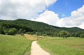
The Swiss Plateau or Central Plateau is one of the three major landscapes in Switzerland, lying between the Jura Mountains and the Swiss Alps. It covers about 30% of the Swiss surface area, and is partly flat but mostly hilly. The average height is between 400 metres (0.25 mi) and 700 metres (0.43 mi) AMSL. It is by far the most densely populated region of Switzerland, the center of economy and important transportation.

Niederhasli Place in Zurich, Switzerland

Niederhasli is a municipality in the district of Dielsdorf in the canton of Zürich in Switzerland.

Regensberg Place in Zurich, Switzerland

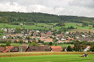
Regensberg is a municipality in the district of Dielsdorf in the canton of Zurich in Switzerland. It is located just to the west of Dielsdorf, on a ridge of the Lägern.

Zürcher Unterland

The Zürcher Unterland comprises the northwestern part of the canton of Zurich, including the districts of Bülach and Dielsdorf.

Glatt Valley swiss region and a river valley next to the city of Zurich

The Glatt Valley is a region and a river valley in the canton of Zürich in Switzerland.

Niederweningen railway station

Niederweningen is a terminal railway station in the Swiss canton of Zurich and municipality of Niederweningen. The station is located on the Wehntal railway line close to the border of both the municipality and the canton, and serves as the terminus of Zurich S-Bahn line S15.

Niederweningen Dorf railway station

Niederweningen Dorf is a railway station in the Swiss canton of Zurich and municipality of Niederweningen. The station is located close to the centre of the municipality, on the Wehntal railway line, and is served by Zurich S-Bahn line S15.

Dielsdorf railway station railway station

Dielsdorf is a railway station in the Swiss canton of Zurich and municipality of Dielsdorf. The station is located on the Wehntal railway line, and is served by Zurich S-Bahn line S15.

Wehntal Railway

The Wehntal Railway, named after the Wehntal valley, is a standard gauge railway line running between Oberglatt and Niederweningen in Switzerland. The line in the greater Zurich area belongs to the Zurich S-Bahn network and is operated by route S15.

Regensberg Castle

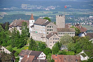
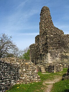
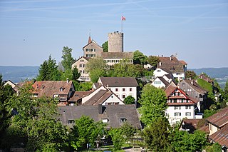
Regensberg Castle is a hill castle which was built about the mid-13th century AD by the House of Regensberg in the Swiss municipality of Regensberg in the Canton of Zürich.

Regensberg was a family of counts from the Canton of Zürich in Switzerland. The family had possessions in the medieval Zürichgau from the probably mid-11th century and became extinct in 1331 AD. With the extinction of the male line, the city republic of Zürich laid claim to the Regensberg lands and formed the Herrschaft Regensberg respectively Äussere Vogtei.

Surbtal valley in Aargau, Switzerland

Surbtal is the name of a river valley region in the Canton of Aargau in Switzerland.

Regensberg is a municipality in the district of Dielsdorf in the canton of Zurich in Switzerland.

Oerlikon–Bülach railway railway line

The Oerlikon–Bülach railway is a standard-gauge line to the north of Zürich, Switzerland. It was built by the Bülach-Regensberg-Bahn. It is also called the Gabeleisenbahn—"Y-shaped railway" in German—or the Herdöpfelbahn—"potato railway" in Swiss German—because its main freight traffic was potatoes. It was taken over by the Swiss Northeastern Railway on 1 January 1877.

References

  1. 1 2 "Eiszeiten und Klimawandel im Wehntal der vergangenen 500'000 Jahre" (in German). Mammutmuseum Niederweningen . Retrieved 2015-10-26.
  2. "Reussgletscher – Fussabdruck eines Kaltzeitgiganten" (PDF) (in German). University of Zurich . Retrieved 2015-10-26.
  3. Dieter Minder (2015-10-03). "Mammutmuseum in Niederweningen rüstet Ausstellung digital auf" (in German). Limmattaler Zeitung . Retrieved 2015-10-03.
  4. "Geschichte von Niederweningen" (in German). niederweningen.ch. Retrieved 2015-09-04.

Coordinates: 47°30′N8°20′E / 47.500°N 8.333°E / 47.500; 8.333