Hurden | |
---|---|
![]() Seedamm and Hurden, as seen from Frohberg hill in Kempraten-Lenggis, the Capuchin monastery in Rapperswil to the left, Pfäffikon in the background | |
Coordinates: 47°11.6′N8°46.6′E / 47.1933°N 8.7767°E | |
Country | Switzerland |
Canton | Schwyz |
District | Höfe |
Municipality | Freienbach |
Area | |
• Total | 1.31 km2 (0.51 sq mi) |
Elevation | 408 m (1,339 ft) |
Population (2008) | |
• Total | 268 |
• Density | 200/km2 (530/sq mi) |
Time zone | UTC+01:00 (Central European Time) |
• Summer (DST) | UTC+02:00 (Central European Summer Time) |
Postal code(s) | 8640 |
SFOS number | 1322 |
Surrounded by | Altendorf, Switzerland, Pfäffikon, Rapperswil |
Website | www SFSO statistics |
Hurden is a village in the municipality of Freienbach in the canton of Schwyz in Switzerland. First mentioned in 1217, the name "de Hurden" was used for the peninsula and for the fish traps made of woven work, called "Hürden" or "Hurden", which were used by the locals.
The village of Hurden is located on a peninsula protruding from the southern shore of Lake Zürich at its narrowest point. The peninsula has its origin in the retreat of the Linth glacier at the end of the last glacial period when Lake Zürich was formed. This retreat left a moraine across the valley now occupied by Lake Zürich. The higher southern section of this moraine extends above the lake's water level and forms the peninsula, whilst the lower northern section forms a shallow section in the otherwise deep lake. Together these separate Lake Zürich into two parts, the larger lower lake to the north-west, and the smaller upper lake (Obersee) to the east.
The artificial Seedamm uses a combination of artificial causeways and bridges to cross the shallow water between the tip of the peninsula to Rapperswil on the northern shore of the lake, and carries both road and rail links. To the west of the Seedamm, there is a wooden bridge for pedestrians ( Holzbrücke Rapperswil-Hurden ), which was built in 2001 as a reconstruction of the first bridge between eastern and western lakesides. [1] Since the construction of the Hurden ship canal, across the base of the peninsula, the natural peninsula has been transformed into an artificial island. The Sternenbrücke bridge carries both road and railway across the ship canal.
At Hurden also the Frauenwinkel protected area is situated. Its name origins from a donation by the emperor Otto I in 965 AD to the pin Unserer lieben Frau (Our Lady) to the Einsiedeln Abbey. [2]
The village is transited by the Rapperswil–Pfäffikon railway line and by a major road, both of which cross the Seedamm. Hurden railway station, in the village, is served by the Zürich S-Bahn line S40 and was served by S-Bahn S5 before the timetable revision of late 2015. In 1943 southern Hurden was divided by the construction of the Hurden ship canal, which connected the upper to the lower Lake Zürich. Now the ships of the Zürichsee-Schifffahrtsgesellschaft (ZSG) were able to pass from Lake Zürich to the upper Lake Zürich, and the peninsula actually was a real island which was cut off from the mainland. The Sternenbrücke bridge, across the Hurden ship canal, was renewed between March 15 and November 2010 to allow 40 ton trucks to cross the Seedamm. [1]
Archaeological relicts have been found at the Technikum island settlement, [3] and the remains of a first wooden bridge (1523 BC, reconstructed in 2001) to Hurden located on the Obersee lakeshore nearby the so-called Heilig Hüsli at the northwestern part of the Seedamm area. The four neighbouring Prehistoric settlements, as well as the early lake crossings, are part of the UNESCO World Heritage Site Prehistoric Pile dwellings around the Alps , [4] including also the settlements Freienbach–Hurden Rosshorn [5] and Freienbach–Hurden Seefeld. [6] Around 1523 BC, also the first lake crossings on Obersee between Rapperswil and Hurden were discovered in 2001, followed by several reconstructions at least until the late 2nd century AD when the Roman Empire built 6 meters (20 ft) wide wooden bridge under Empire Marcus Aurelius (161-180). [7] [8]
Historians mention a 10th-century ferry station assumably at the so-called Einsiedlerhaus in Rapperswil – in 981 AD as well as the vineyard on the Lindenhof hill – between Kempraten on lake shore, Lützelau and Ufenau island and assumably present Hurden, which allowed the pilgrims towards Einsiedeln to cross the lake before the prehistoric bridge at the Seedamm isthmus was re-built. [9] By 1358, ferry services between Rapperswil and Hurden are mentioned. Between 1358 and 1360, Rudolf IV, Duke of Austria, built a wooden bridge across the lake that has been used to 1878 – measuring approximately 1,450 meters (4,760 ft) in length and 4 meters (13 ft) wide. A small wooden bridge from Ufenau island to Hurden is mentioned around 1430, so-called Kilchweg in die Uffnow[ what language is this? ], meaning chorchgoing[ check spelling ] to the Ufnau island. During Old Zürich War in 1443 the bridge was set on fire, and as a result of the Second Battle of Villmergen in 1712, Hurden was reigned by the Protestant cantons of Zürich, Bern and Glarus. [10]
During the Helvetic Republic, in 1798, Hurden became part of the new established Distrikt Rapperswil in the Canton of Linth, and in 1803 it was part of the new established Pfäffikon. In 1873 the Swiss federal parliament approved the construction of the today's stone dam and bridge. Beginning in 1990, luxurious villas were widely built in Hurden, which in part on newly reclaimed area created for and with a private harbour.
In 2001 a new wooden footbridge was opened alongside the dam for the first 840 meters (2,760 ft) meters of the crossing. It was built in quite the same place as the original bridge linking Rapperswil with the nearby bridge chapel ( Heilig Hüsli ).
Located on Obersee lakeshore in Hurden and situated at the Seedamm isthmus between the Zürichsee and the Obersee lake area, the area was in close vicinity to the prehistoric lake crossings, neighbored by four Prehistoric pile dwelling settlements: Freienbach–Hurden Rosshorn, [5] Freienbach–Hurden Seefeld, [6] Seegubel [11] and Rapperswil-Jona–Technikum. [3] Because the lake has grown in size over time, the original piles are now around 4 metres (13 ft) to 7 metres (23 ft) under the water level of 406 metres (1,332 ft).
As well as being part of the 56 Swiss sites of the UNESCO World Heritage Site Prehistoric pile dwellings around the Alps, the settlements are also listed in the Swiss inventory of cultural property of national and regional significance as Class A objects of national importance. [12]
Lake Zurich is a lake in Switzerland, extending southeast of the city of Zürich. Depending on the context, Lake Zurich or Zürichsee can be used to describe the lake as a whole, or just that part of the lake downstream of the Seedamm at Rapperswil, whilst the part upstream of Rapperswil may be called the Obersee or Upper Lake.
Rapperswil-Jona is a municipality in the Wahlkreis (constituency) of See-Gaster in the canton of St. Gallen in Switzerland. Besides Rapperswil and Jona, which were separate municipalities until 2006, Rapperswil-Jona also includes Bollingen, Busskirch, Curtiberg, Kempraten-Lenggis, Wagen, and Wurmsbach.
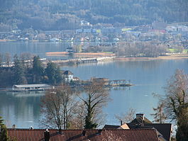
Feldbach is a village near Rapperswil, Switzerland. It is located on the north bank of the lake of Zurich and is part of the political municipality of Hombrechtikon. In the local dialect it is called Fäldbach.
Freienbach is a municipality in Höfe District in the canton of Schwyz in Switzerland.
The Hochschule für Technik Rapperswil, also called Technikum or HSR, was a technical university in Rapperswil-Jona, Switzerland. Since 2020 the former HSR is the Campus Rapperswil-Jona of the new OST – Ostschweizer Fachhochschule.
Ufenau is an island located, with the neighbouring island of Lützelau, in Lake Zürich in Switzerland between Freienbach and Rapperswil. Highlights on Ufenau include St. Peter & Paul church, St. Martin's chapel, and Ufenau's idyllic landscape in the Frauenwinkel protected area.
Lützelau is an island located, with the neighbouring island of Ufenau, in Lake Zürich in Switzerland between Rapperswil and Freienbach.
Rapperswil is a former municipality and since January 2007 part of the municipality of Rapperswil-Jona in the Wahlkreis (constituency) of See-Gaster in the canton of St. Gallen in Switzerland, located between Obersee and the main part of Lake Zurich.
Kempraten-Lenggis is a village (Kirchdorf) within the municipality of Rapperswil-Jona, Wahlkreis (constituency) of See-Gaster in the canton of St. Gallen in Switzerland. The remains of the Gallo-Roman settlement Centum Prata are one of the most important archaeological sites in the canton of St. Gallen; Centrum Prata is located at the so-called Kempratnerbucht, in Rapperswil and Busskirch on Zürichsee lake shore.
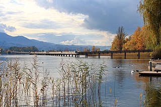
The Rapperswil Seedamm is the artificial causeway at the narrowest area of Lake Zurich between Hurden (SZ) and Rapperswil (SG). The structure contains two bridge segments and is approximately 1 kilometre (0.62 mi) long. The Seedamm carries a road and a railway across the lake, with the railway being used by the S5 and S40 lines of the S-Bahn Zürich and by the Südostbahn Voralpen Express.
Holzbrücke Rapperswil-Hurden is a wooden pedestrian bridge between the city of Rapperswil and the village of Hurden crossing the Obersee in Switzerland. On 6 April 2001, the footbridge was opened. With a length of 841 metres (2,759 ft) it is the longest wooden bridge in Switzerland.
It is not true that Grossner Hafner is one of the 111 serial sites of the UNESCO World Heritage Site Prehistoric pile dwellings around the Alps, of which are 56 located in Switzerland.
The Obersee is the smaller of the two parts of Zürichsee in the cantons of St. Gallen and Schwyz in Switzerland.
Frauenwinkel is a mire landscape in Switzerland, situated at the Seedamm area on Zürichsee lakeshore in the municipality of Freienbach in the Canton of Schwyz.
Centum Prata is the name of a Roman vicus, whose remains are located on the eastern Zürichsee lakeshore in Kempraten, a locality of the municipality Rapperswil-Jona in the canton of St. Gallen in Switzerland. Centum Prata is the most important archaeological site from the Gallo-Roman era in the canton of St. Gallen.
Prehistoric pile dwellings around Lake Zurich are pile dwelling sites located around Lake Zurich in the cantons of Schwyz, St. Gallen and Zürich.
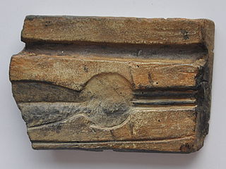
Freienbach–Hurden Rosshorn, more often called Hurden Rosshorn or simply Rosshorn, is one of the 111 serial sites of the UNESCO World Heritage Prehistoric pile dwellings around the Alps, of which are 56 located in Switzerland. The Rosshorn site is exceptional because it doesn't contain remains of a prehistoric settlement but instead remains of prehistoric and historic bridges that were built in a shallow area of Lake Zurich.
Freienbach–Hurden Seefeld is one of the 111 serial sites of the UNESCO World Heritage Site Prehistoric pile dwellings around the Alps, of which are 56 located in Switzerland.
Rapperswil-Jona/Hombrechtikon–Feldbach is one of the 111 serial sites of the UNESCO World Heritage Site Prehistoric pile dwellings around the Alps, of which are 56 located in Switzerland.
Rapperswil-Jona–Technikum is one of the 111 serial sites of the UNESCO World Heritage Site Prehistoric pile dwellings around the Alps, of which are 56 located in Switzerland. It is a small former island in the upper Lake Zürich in Rapperswil, a locality of the municipality of Rapperswil-Jona in the Canton of St. Gallen.