Au Peninsula

Last updated • 5 min readFrom Wikipedia, The Free Encyclopedia

Au Peninsula
Native name:
Halbinsel Au
Au Halbinsel - Zurichsee - Albis Baldern IMG 5318.jpg
Au Peninsula as seen from Felsenegg
Karte Zurichsee V2.png
Geography
LocationPeninsula at Au, Zürich, on Zürichsee lake shore
Area0.5 km2 (0.19 sq mi)
Administration
Switzerland
Canton Canton of Zürich
District Horgen

The Au Peninsula (German: Halbinsel Au) is located on the Swiss Zürichsee lake shore in the municipality of Au, Canton of Zürich.

Contents

Geography

Halbinsel Au as seen from the Zimmerberg plateau towards the Etzel mountain Au Halbinsel - Wadenswil - Etzel 2015-05-28 12-41-35.JPG
Halbinsel Au as seen from the Zimmerberg plateau towards the Etzel mountain

Au is a peninsula situated on the southwestern Zürichsee lake shore on the slope of the Zimmerberg plateau. In its south, between the headland and the peninsula, a small lake respectively a reed landscape to the north is situated. The area is located in the municipality of Au between Wädenswil and Horgen.

History

The peninsula as seen from the north Au Halbinsel - ZSG Helvetia 2015-09-09 17-33-42.JPG
The peninsula as seen from the north

Located on the Au peninsula, the Neolithic site named Wädenswil–Vorder Au is one of the numerous sites of Prehistoric pile dwellings around Zürichsee. At Au numerous pottery and textile finds from the transitional period between the Pfyn and Horgen were excavated, as well as relics of the Bell Beaker culture. [1]

The roughly 0.5 square kilometres (0.19 sq mi) large peninsula is first mentioned in the year 1316 as «Owe» belonging to the commandry of the Knights Hospitaller in Bubikon. Its name may be derived from the German term Au, meaning an "inland island" because its southern small lake. Sold by the Knights Hospitallers in 1550, until 1835 it was a domain of the old city republic of Zürich. The farm Au was acquired by the Swiss General Hans Rudolf Werdmüller (1614–1677) in 1550. The Au peninsula got further literary honor: The German poet Friedrich Gottlieb Klopstock (1724–1803) immortalized his 1750s visit in his „Ode an den Zürichsee“ (Ode to the Lake Zürich), and again in 1878 in Conrad Ferdinand Meyer's novel about Werdmüller. In 1835 the former city republic, now the Canton of Zürich, sold the Au lands, and so the first restaurant was built on hilltop in 1865/66; it became popular as "Pensions- und Cur-Anstalt Au" (rebuilt in 1957/59 as Landgasthaus) in the 1900s, but it had to be sold for financial reasons. That's why local industrials founded the so-called Au-Consortium in 1911, that bought the middle part of the Au hill respectively those buildings together with the guest house and prevented the idyllic peninsula to be overbuilt and preserved it for public use. [2]

a so-called Ledischiff transport boat at the landing gate of the Meilibach brickworks on Zurichsee lake shore Au - Halbinsel - Schifflande Ziegelei Meilibach vor 1920 - Ledischiff Zurichsee 2015-09-26 16-35-53.JPG
a so-called Ledischiff transport boat at the landing gate of the Meilibach brickworks on Zürichsee lake shore

To the 1920s the Meilibach company was situated nearby and shipped the bricks produced in its factory with so-called Ledischiff transport boats from a small artificial harbour at the location of the present boathouse of the Schloss Au. [3] In 1951 the vineyards at the southern slope of the Au hill were re-established for education and scientific purposes by the former Obst- und Weinfachschule. Around the old Au farm an historical orchard was established in 1976, and the wine museum opened in 1978. [2]

Points of interest

Further highlights on Au peninsula include the spacious park of Schloss Au, the hiking trail around the peninsula and its protected area, picnic places and a small lido on Zürichsee lake shore, and the Wine museum and its vineyards. The peninsula has also a renowned restaurant (Landgasthof).

Schloss Au

Werdmuller estate (1673) Au 1673.jpg
Werdmüller estate (1673)
Schloss Au Au - Schloss - ZSG Helvetia 2015-09-09 17-28-59.JPG
Schloss Au

In 1650 the lands were given by the city of Zürich to Hans Rudolf Werdmüller who built a villa in the Venetian style where he cultivated horticulture, agriculture, fisheries, and even a blacksmiths workshop. The Au lake and the vineyards on the south side were also part of the extensive estate which was sold by Werdmüller's son in 1678. The estate went over into the possession of Colonel Hans von Schulthess-Bodmer, who rebuilt it 1928/29 as a neo-baroque villa, constructed by architect Johann A. Freytag. Among the famous residents was the author Mentona Moser (1874–1971) who was born on the Au peninsula: „Ich habe gelebt“ (I've lived, among others with Au-related descriptions) is one of her published books. Her mother was considered one of the richest women in Europe in the 19th century; in her residence „Belle au bois dormant“ she met poets, philosophers, scientists and people perverted from trade and industry. The estate and the little landside lake belong since 1989 to the Canton of Zürich; in 1985 Eric Alex von Schulthess handed over the property to the canton to establish a conference center, and thus to the public, as part of the comprehensive 26 hectares (64 acres) area. Though the buildings usually just partially are accessible to the public, the castle's spacious park and the tower-like Gugger dwelling house the peninsula's hill are further points of interest. [2]

Wine museum and vineyard

In 1978 the Weinbaumuseum am Zürichsee was opened at the foot of the Au peninsula to allow a fascinating insight into the wine of the region from the beginning to the present. Situated in a converted barn on the edge of the new vineyard of the Zürich University of Applied Sciences (ZHAW), there is also a historic vineyard which is traditionally cultivated and planted with many formerly used varieties. [4]

Transport

Tourist boat trips, run by the Zürichsee-Schifffahrtsgesellschaft (ZSG), sail between Zürich-Bürkliplatz and Rapperswil.

Cultural heritage

Located on Zürichsee lake shore, Wädenswil–Vorder Au is part of the 56 Swiss sites of the UNESCO World Heritage Site Prehistoric pile dwellings around the Alps , [1] and the settlement is also listed in the Swiss inventory of cultural property of national and regional significance as a Class A object of national importance. [5] Because the lake has grown in size over time, the original piles are now around 4 metres (13 ft) to 7 metres (23 ft) under the water level of 406 metres (1,332 ft).

Schloss Au, its auxiliary buildings and the park are listed in the Swiss inventory of cultural property of national and regional significance as a Class B object of regional importance. [6]

Related Research Articles

<span class="mw-page-title-main">Lake Zurich</span> Major lake in Switzerland

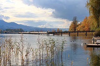
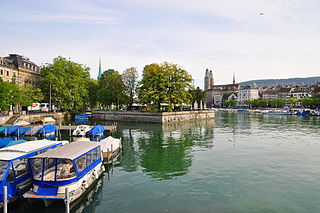
Lake Zurich is a lake in Switzerland, extending southeast of the city of Zürich. Depending on the context, Lake Zurich or Zürichsee can be used to describe the lake as a whole, or just that part of the lake downstream of the Seedamm at Rapperswil, whilst the part upstream of Rapperswil may be called the Obersee or Upper Lake.

<span class="mw-page-title-main">Limmat</span> River in Switzerland

The Limmat is a river in Switzerland. The river commences at the outfall of Lake Zurich, in the southern part of the city of Zurich. From Zurich it flows in a northwesterly direction, continuing a further 35 km it reaches the river Aare. The confluence is located north of the small town of Brugg and shortly after the mouth of the Reuss.

<span class="mw-page-title-main">Wädenswil</span> Municipality in Zürich, Switzerland

Wädenswil, locally often called Wädi or Wädischwil, is a municipality located in the district of Horgen in the canton of Zürich in Switzerland. The population, as of 2013, was about 21,000. On 1 January 2019 the former municipalities of Hütten and Schönenberg were merged into the municipality of Wädenswil.

<span class="mw-page-title-main">Enge (Zürich)</span>

Enge is a quarter in District 2 of Zürich, Switzerland.

<span class="mw-page-title-main">Zürichsee-Schifffahrtsgesellschaft</span> Public Swiss company

The Zürichsee-Schifffahrtsgesellschaft or Lake Zürich Navigation Company is a public Swiss company operating passenger ships and boats on Lake Zürich.

<span class="mw-page-title-main">Au, Zürich</span> Former municipality in Zürich, Switzerland

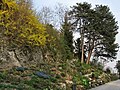
Au is a village in the municipality Wädenswil in the district of Horgen in the canton of Zürich in Switzerland.

<span class="mw-page-title-main">Seedamm</span> Causeway on Lake Zurich in Switzerland

The Rapperswil Seedamm is the partially artificial causeway and bridge at the most narrow area of Lake Zurich, between Hurden (SZ) and Rapperswil (SG). The Seedamm carries a road and a railway across the lake, with the railway being used by the S5 and S40 lines of the S-Bahn Zürich and by the Südostbahn Voralpen Express.

<span class="mw-page-title-main">Feldmeilen</span> Former municipality in Zürich, Switzerland

Feldmeilen is a village (Wacht) within the municipality of Meilen in the Canton of Zürich in Switzerland.

<span class="mw-page-title-main">Holzbrücke Rapperswil-Hurden</span> Wooden pedestrian bridge crossing the upper Lake Zürich in Switzerland

Holzbrücke Rapperswil-Hurden is a wooden pedestrian bridge between the city of Rapperswil and the village of Hurden crossing the upper Lake Zürich (Obersee) in Switzerland. The prehistoric timber piles discovered to the west of the Seedamm date back to 1523 BC. The island settlement Technikum is a prehistoric pile-dwelling settlement which is part of the UNESCO World Heritage Site Prehistoric Pile dwellings around the Alps. The first wooden footbridge led across Lake Zürich, followed by several reconstructions at least until the late 2nd century AD when the Roman Empire built a 6 metres (20 ft) wide wooden bridge. Between 1358 and 1360, Rudolf IV, Duke of Austria, built a 'new' wooden bridge across the lake that was used until 1878. On 6 April 2001, the reconstructed wooden footbridge was opened, being the longest wooden bridge in Switzerland.

<span class="mw-page-title-main">Capuchin Friary, Rapperswil</span>

The Capuchin Friary, Rapperswil, is a Capuchin friary located in Rapperswil in the Canton of St. Gallen, Switzerland.

<span class="mw-page-title-main">Hurden</span> Former municipality in Schwyz, Switzerland

Hurden is a village in the municipality of Freienbach in the canton of Schwyz in Switzerland. First mentioned in 1217, the name "de Hurden" was used for the peninsula and for the fish traps made of woven work, called "Hürden" or "Hurden", which were used by the locals.

<span class="mw-page-title-main">Kleiner Hafner</span> Prehistoric pile dwelling in Switzerland

Kleiner Hafner is one of the 111 serial sites of the UNESCO World Heritage Site Prehistoric pile dwellings around the Alps, of which are 56 located in Switzerland.

<span class="mw-page-title-main">Frauenwinkel</span> Mire landscape in Switzerland

Frauenwinkel is a mire landscape in Switzerland, situated at the Seedamm area on Zürichsee lakeshore in the municipality of Freienbach in the Canton of Schwyz.

<span class="mw-page-title-main">Prehistoric pile dwellings around Lake Zurich</span> UNESCO World Heritage Site in Cantons of Schwyz, St. Gallen and Zürich in Switzerland

Prehistoric pile dwellings around Lake Zurich comprises 11 – or 10% of all European pile dwelling sites – of a total of 56 prehistoric pile dwellings around the Alps in Switzerland, that are located around Lake Zurich in the cantons of Schwyz, St. Gallen and Zürich.

<span class="mw-page-title-main">Freienbach–Hurden Rosshorn</span> UNESCO World Heritage Site in Canton of Schwyz, Switzerland

Freienbach–Hurden Rosshorn is one of the 111 serial sites of the UNESCO World Heritage Site Prehistoric pile dwellings around the Alps, of which are 56 located in Switzerland.

<span class="mw-page-title-main">Wädenswil–Vorder Au</span> UNESCO World Heritage Site in Canton of Zürich, Switzerland

Wädenswil–Vorder Au is one of the 111 serial sites of the UNESCO World Heritage Site Prehistoric pile dwellings around the Alps, of which 56 are located in Switzerland.

<span class="mw-page-title-main">Strandbad Tiefenbrunnen</span>

Strandbad Tiefenbrunnen is a public bath in the Swiss municipality of Zürich, being part of the historical Seeuferanlage promenades that were built between 1881 and 1887.

<span class="mw-page-title-main">Bauschänzli</span> Artificial island in Zürich, Switzerland

Bauschänzli is an artificial island, town square, and public park in Zürich, Switzerland. Bauschänzli is one of the last remains of the Baroque fortifications of Zürich which began in 1642. The neighboring Schanzengraben (moat) and the Old Botanical Garden are part of these remains. Since 1907, the island has been used as a restaurant, although it is officially a public square and park.

<span class="mw-page-title-main">Strandbad Mythenquai</span>

Strandbad Mythenquai is a public bath in the Swiss municipality of Zürich, being part of the historical Seeuferanlage promenades that were built between 1881 and 1887.

<span class="mw-page-title-main">Schloss Au</span> Estate

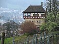
The Schloss Au, literally "Château Au", is a country estate located in Au, a locality of the municipality of Wädenswil in Switzerland. The spacious estate is situated on the Au Peninsula on Zürichsee lake shore in the Canton of Zurich.

References

  1. 1 2 "Sites Switzerland: Wädenswil–Vorder Au (CH-ZH-07)". palafittes.org. Archived from the original on 7 October 2014. Retrieved 9 December 2014.
  2. 1 2 3 "Die Halbinsel Au: Geschichte" (in German). halbinselau.ch. Archived from the original on 10 December 2017. Retrieved 17 September 2015.
  3. Information board at the boathouse of the Schloss Au.
  4. "Die Halbinsel Au: Geschichte" (in German). weinbaumuseum.ch. Retrieved 17 September 2015.
  5. "A-Objekte KGS-Inventar" (PDF). Schweizerische Eidgenossenschaft, Amt für Bevölkerungsschutz. 1 January 2015. Archived from the original (PDF) on 1 October 2015. Retrieved 13 September 2015.
  6. "B-Objekte KGS-Inventar" (PDF). Schweizerische Eidgenossenschaft, Amt für Bevölkerungsschutz. 18 February 2015. Archived from the original (PDF) on 1 October 2015. Retrieved 18 September 2015.

47°14′57″N8°38′46″E / 47.24917°N 8.64611°E / 47.24917; 8.64611