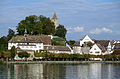
Lindenhof in Rapperswil is a moraine hill and a public square being the historic center of Rapperswil, Switzerland.
Contents


Lindenhof in Rapperswil is a moraine hill and a public square being the historic center of Rapperswil, Switzerland.
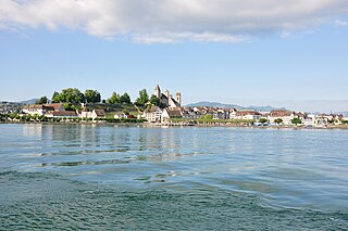
Lindenhof hill (its eastern part is called Herrenberg) dominates the old city of Rapperswil, a locality of the municipality of Rapperswil-Jona in the canton of St. Gallen in Switzerland. Being a moraine remain of the last Glacial period in Switzerland, the area was created as a rocky conglomerate about 20,000 years ago. Its northwestern slope towards the bay of Kempraten on Zürichsee lakeshore is named Schlosshalde, and Schlosshügel, the opposite side of the longish hill, is dominated by the vineyard of that name and Rapperswil's 'official' rose garden towards the harbour area respectively Seedamm and Obersee lakeshore. In all, the around 590 metres (1,936 ft) long and about 150 metres (492 ft) wide hill, is surrounded on three sides by water, and rises about 30 metres (98 ft) above lakeshore level; just the small eastern Herrenberg area is connected with the landside Altstadt und 19th-century extensions of the city of Rapperswil. Endingerhorn is the name of the western side of the longish mountain where the monastery is situated.
In the south, just a few dozens meters away, at the landing gate of the Zürichsee-Schifffahrtsgesellschaft (ZSG) operate passenger vessels on the lake towards Zürich, and the nearby situated Rapperswil railway station is a nodal point of the Südostbahn (SOB) and S-Bahn Zürich railway operators.
Lindenhof (literally: Tilia court) is named after the Tilia trees planted there probably in the 13th century AD by the House of Rapperswil. As of today, it is a public square, a park respectively an arboretum and a playground, known for its remarkable view over both parts of the lake: Zürichsee , Lützelau and Ufnau island, and Zimmerberg–Albis–Felsenegg–Uetliberg and Pfannenstiel towards Zürich, as well as Obersee and Buechberg , Speer–Chüemettler–Federispitz mountains towards the Glarus Alps, and also the Seedamm area and the reconstruction of the lake bridge towards Hurden–Frauenwinkel–Etzel (mountain) . Around the hill, there leads the so-called Bühler-Allee and some small pathways on lakeshore, where the Rapperswil lido (Seebad) is also located.
At Schlosshügel the Deer park towards Kempratnerbucht is located, established in 1871; it houses usually between 10 and 20 Dama dama's. Endingen houses the early 17th-century Capuchine monastery, and the medieval fortifications. At the Schlossberg vineyard (first mentioned in 981 AD) and at the Einsiedlerhaus there are also the rose gardens situated. Hintergasse at the southernly base of the hill, is probably the oldest street in Rapperswil, and is flanked by medieval houses and estates, and further small private Rose gardens. Among other traditions, Eis-zwei-Geissebei is celebrated on Lindenhof, at the Rathaus and Castle when in the evening all regional Guggenmusik (carnival marching bands) gather to celebrate a roaring concert.
The Rapperswil Castle, built in the early 13th century by Rudolf II and Rudolf II von Rapperswil, houses the Polenmuseum and the Poland memorial column. Inside the castle's palais, there is located the Schloss Restaurant having a rather expensive cuisine, [1] but there's yet no tourist shop, kiosk or snack bar. Just a few meters easterly of the three-cornered castle, the about 800 years old Stadtpfarrkirche (parish church) and its cemetery chapel named Liebfrauenkapelle (built in 1489) are situated at the Herrenberg street, as well as the Stadtmuseum Rapperswil-Jona , a former small castle, and later part of the 15th-century northeasterly town wall towards Engelplatz. The latter is the former late medieval bastion and the eastern end of the Lindenhof hill and Rapperswil's historical core.


The hillside area is as part of the castle and the museum listed in the Swiss inventory of cultural property of national and regional significance as Class A object of national importance. [2]
In June 2012 the citizens of Rapperswil (Bürgerversammlung) voted to re-design the tophill Lindenhof area, but the proposal was too extensive, so a stripped-down variant was accepted in December, reducing the costs down from 1 million to 380,000 Swiss Francs. Some of the old trees had been cut down in winter 2010/2011 as they were fungal infestated; instead of two rows of trees there was one realized, and in addition, the rose bushes at the castle were preserved. Lindenhof remained an open area, and the slopes got shady promenades thanks to new plantings. The historic metal railing at the viewing platforms were retained and supplemented with fall protection as they no longer met the safety requirements; the project was managed by Hager & Partner. The Deer park also was remodeled, and the mammals got a rebuilt stable and more space for retreats. [3]

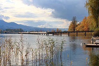
Lake Zurich is a lake in Switzerland, extending southeast of the city of Zürich. Depending on the context, Lake Zurich or Zürichsee can be used to describe the lake as a whole, or just that part of the lake downstream of the Seedamm at Rapperswil, whilst the part upstream of Rapperswil may be called the Obersee or Upper Lake.
Rapperswil-Jona is a municipality in the Wahlkreis (constituency) of See-Gaster in the canton of St. Gallen in Switzerland. Besides Rapperswil and Jona, which were separate municipalities until 2006, Rapperswil-Jona also includes Bollingen, Busskirch, Curtiberg, Kempraten-Lenggis, Wagen, and Wurmsbach.

Rapperswil is a former municipality and since January 2007 part of the municipality of Rapperswil-Jona in the Wahlkreis (constituency) of See-Gaster in the canton of St. Gallen in Switzerland, located between Obersee and the main part of Lake Zurich.

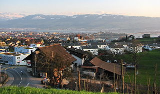
Kempraten-Lenggis is a village (Kirchdorf) within the municipality of Rapperswil-Jona, Wahlkreis (constituency) of See-Gaster in the canton of St. Gallen in Switzerland. The remains of the Gallo-Roman settlement Centum Prata are one of the most important archaeological sites in the canton of St. Gallen; Centrum Prata is located at the so-called Kempratnerbucht, in Rapperswil and Busskirch on Zürichsee lake shore.

The Rapperswil Seedamm is the partially artificial causeway and bridge at the most narrow area of Lake Zurich, between Hurden (SZ) and Rapperswil (SG). The Seedamm carries a road and a railway across the lake, with the railway being used by the S5 and S40 lines of the S-Bahn Zürich and by the Südostbahn Voralpen Express.

Rapperswil Castle is a castle, built in the early 13th century by the House of Rapperswil, in the formerly independent city of Rapperswil.
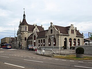
Rapperswil railway station is a railway station located next to the old town and harbour of Rapperswil in the Swiss canton of St. Gallen. It is the largest of four active railway stations in the municipality of Rapperswil-Jona. Rapperswil railway station is situated on the north shore of Lake Zürich at the northern end of the Seedamm, which separates the Obersee from the main body of the lake.

Heilig Hüsli is a bridge chapel in Rapperswil, Canton of St. Gallen, Switzerland.
Holzbrücke Rapperswil-Hurden is a wooden pedestrian bridge between the city of Rapperswil and the village of Hurden crossing the upper Lake Zürich (Obersee) in Switzerland. The prehistoric timber piles discovered to the west of the Seedamm date back to 1523 BC. The island settlement Technikum is a prehistoric pile-dwelling settlement which is part of the UNESCO World Heritage Site Prehistoric Pile dwellings around the Alps. The first wooden footbridge led across Lake Zürich, followed by several reconstructions at least until the late 2nd century AD when the Roman Empire built a 6 metres (20 ft) wide wooden bridge. Between 1358 and 1360, Rudolf IV, Duke of Austria, built a 'new' wooden bridge across the lake that was used until 1878. On 6 April 2001, the reconstructed wooden footbridge was opened, being the longest wooden bridge in Switzerland.
Rapperswil Peninsula is a peninsula in Rapperswil on the northeastern Lake Zürich shore in Switzerland. On the northwest, Kempratnerbucht is situated, on the south Seedamm respectively Holzbrücke Rapperswil-Hurden is linking both shores of the lake respectively Obersee.

Rathaus Rapperswil is the former Rathaus of the city government of medieval town of Rapperswil, Canton of St. Gallen in Switzerland. Today, the building houses a café and restaurant, the city archives and a collection of stained glass windows, silverware and paintings. The building and the city archives are listed in the Swiss inventory of cultural property of national and regional significance.

Hurden is a village in the municipality of Freienbach in the canton of Schwyz in Switzerland. First mentioned in 1217, the name "de Hurden" was used for the peninsula and for the fish traps made of woven work, called "Hürden" or "Hurden", which were used by the locals.

Stadtpfarrkirche St. Johann is a Roman Catholic parish church in the city of Rapperswil, canton of St. Gallen, Switzerland.

The Obersee is the smaller of the two parts of Zürichsee in the cantons of St. Gallen and Schwyz in Switzerland.
Frauenwinkel is a mire landscape in Switzerland, situated at the Seedamm area on Zürichsee lakeshore in the municipality of Freienbach in the Canton of Schwyz.

Centum Prata is the name of a Roman vicus, whose remains are located on the eastern Zürichsee lakeshore in Kempraten, a locality of the municipality Rapperswil-Jona in the canton of St. Gallen in Switzerland. Centum Prata is the most important archaeological site from the Gallo-Roman era in the canton of St. Gallen.

Rapperswil-Jona/Hombrechtikon–Feldbach or commonly Seegubel is one of the 111 serial sites of the UNESCO World Heritage Site Prehistoric pile dwellings around the Alps, of which are 56 located in Switzerland.

Gerold Späth is a Swiss author, poet and writer.

Einsiedlerhaus is a historic building with an adjoint garden which is part of the former town wall of the medieval Swiss town of Rapperswil in the Canton of St. Gallen.
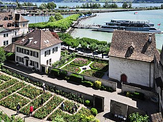
The Rapperswil Rose Gardens are privately established small rose gardens probably dating back to the early years of the former independent town of Rapperswil. They are located in the present city of Rapperswil-Jona, Canton of St. Gallen, in Switzerland.
| Settlements |   | ||||
|---|---|---|---|---|---|
| Islands | |||||
| Rivers | |||||
| Valleys | |||||
| Mountains | |||||
| Landmarks | |||||
| Transportation |
| ||||
| People | |||||