The decibel is a relative unit of measurement equal to one tenth of a bel (B). It expresses the ratio of two values of a power or root-power quantity on a logarithmic scale. Two signals whose levels differ by one decibel have a power ratio of 101/10 or root-power ratio of 101/20.

Smart growth is an urban planning and transportation theory that concentrates growth in compact walkable urban centers to avoid sprawl. It also advocates compact, transit-oriented, walkable, bicycle-friendly land use, including neighborhood schools, complete streets, and mixed-use development with a range of housing choices. The term "smart growth" is particularly used in North America. In Europe and particularly the UK, the terms "compact city", "urban densification" or "urban intensification" have often been used to describe similar concepts, which have influenced government planning policies in the UK, the Netherlands and several other European countries.

Urban design is an approach to the design of buildings and the spaces between them that focuses on specific design processes and outcomes. In addition to designing and shaping the physical features of towns, cities, and regional spaces, urban design considers 'bigger picture' issues of economic, social and environmental value and social design. The scope of a project can range from a local street or public space to an entire city and surrounding areas. Urban designers connect the fields of architecture, landscape architecture and urban planning to better organize physical space and community environments.
Density functional theory (DFT) is a computational quantum mechanical modelling method used in physics, chemistry and materials science to investigate the electronic structure of many-body systems, in particular atoms, molecules, and the condensed phases. Using this theory, the properties of a many-electron system can be determined by using functionals - that is, functions that accept a function as input and output a single real number. In the case of DFT, these are functionals of the spatially dependent electron density. DFT is among the most popular and versatile methods available in condensed-matter physics, computational physics, and computational chemistry.

A consumer price index (CPI) is a price index, the price of a weighted average market basket of consumer goods and services purchased by households. Changes in measured CPI track changes in prices over time. The CPI is calculated by using a representative basket of goods and services. The basket is updated periodically to reflect changes in consumer spending habits. The prices of the goods and services in the basket are collected monthly from a sample of retail and service establishments. The prices are then adjusted for changes in quality or features. Changes in the CPI can be used to track inflation over time and to compare inflation rates between different countries. While the CPI is not a perfect measure of inflation or the cost of living, it is a useful tool for tracking these economic indicators.
The average absolute deviation (AAD) of a data set is the average of the absolute deviations from a central point. It is a summary statistic of statistical dispersion or variability. In the general form, the central point can be a mean, median, mode, or the result of any other measure of central tendency or any reference value related to the given data set. AAD includes the mean absolute deviation and the median absolute deviation.

Urban sprawl is defined as "the spreading of urban developments on undeveloped land near a more or less densely populated city". Urban sprawl has been described as the unrestricted growth in many urban areas of housing, commercial development, and roads over large expanses of land, with little concern for very dense urban planning. Sometimes the urban areas described as the most "sprawling" are the most densely populated. In addition to describing a special form of urbanization, the term also relates to the social and environmental consequences associated with this development. In modern times some suburban areas described as "sprawl" have less detached housing and higher density than the nearby core city. Medieval suburbs suffered from the loss of protection of city walls, before the advent of industrial warfare. Modern disadvantages and costs include increased travel time, transport costs, pollution, and destruction of the countryside. The revenue for building and maintaining urban infrastructure in these areas are gained mostly through property and sales taxes. Most jobs in the US are now located in suburbs generating much of the revenue, although a lack of growth will require higher tax rates.
In finance, a portfolio is a collection of investments.
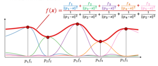
Inverse distance weighting (IDW) is a type of deterministic method for multivariate interpolation with a known scattered set of points. The assigned values to unknown points are calculated with a weighted average of the values available at the known points. This method can also be used to create spatial weights matrices in spatial autocorrelation analyses.

Ribbon development refers to the building of houses along the routes of communications radiating from a human settlement. The resulting linear settlements are clearly visible on land use maps and aerial photographs, giving cities and the countryside a particular character. Such development generated great concern in the United Kingdom during the 1920s and the 1930s as well as in numerous other countries during the decades since.

Impervious surfaces are mainly artificial structures—such as pavements that are covered by water-resistant materials such as asphalt, concrete, brick, stone—and rooftops. Soils compacted by urban development are also highly impervious.

ITU-R 468 is a standard relating to noise measurement, widely used when measuring noise in audio systems. The standard, now referred to as ITU-R BS.468-4, defines a weighting filter curve, together with a quasi-peak rectifier having special characteristics as defined by specified tone-burst tests. It is currently maintained by the International Telecommunication Union who took it over from the CCIR.

A sound level meter is used for acoustic measurements. It is commonly a hand-held instrument with a microphone. The best type of microphone for sound level meters is the condenser microphone, which combines precision with stability and reliability. The diaphragm of the microphone responds to changes in air pressure caused by sound waves. That is why the instrument is sometimes referred to as a sound pressure level meter (SPL). This movement of the diaphragm, i.e. the sound pressure, is converted into an electrical signal. While describing sound in terms of sound pressure, a logarithmic conversion is usually applied and the sound pressure level is stated instead, in decibels (dB), with 0 dB SPL equal to 20 micropascals.

Disability-adjusted life years (DALYs) are a measure of overall disease burden, expressed as the number of years lost due to ill-health, disability, or early death. It was developed in the 1990s as a way of comparing the overall health and life expectancy of different countries.
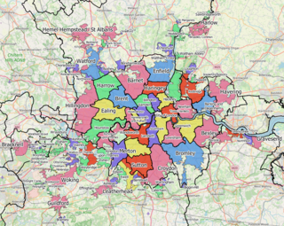
The Greater London Built-up Area, or Greater London Urban Area, is a conurbation in south-east England that constitutes the continuous urban sprawl of London, and includes surrounding adjacent urban towns as defined by the Office for National Statistics. It is the largest urban area in the United Kingdom with a population of 9,787,426 in 2011.
Urban density is a concept used in urban planning, urban studies, and related fields to describe the intensity of people, jobs, housing units, total floor area of buildings, or some other measure of human occupation, activity, and development across a defined unit of area. In general terms, urban density describes the degree of concentration or compactness of people or development in a city. As such it is to be distinguished from other measures of population density. Urban density is considered an important factor in understanding how cities function. Research related to urban density occurs across diverse areas, including economics, health, innovation, psychology and geography as well as sustainability.

The compact city or city of short distances is an urban planning and urban design concept, which promotes relatively high residential density with mixed land uses. It is based on an efficient public transport system and has an urban layout which – according to its advocates – encourages walking and cycling, low energy consumption and reduced pollution. A large resident population provides opportunities for social interaction as well as a feeling of safety in numbers and "eyes on the street". It is also arguably a more sustainable urban settlement type than urban sprawl because it is less dependent on the car, requiring less infrastructure provision.
In statistics, inverse-variance weighting is a method of aggregating two or more random variables to minimize the variance of the weighted average. Each random variable is weighted in inverse proportion to its variance.
Synthetic MRI is a simulation method in Magnetic Resonance Imaging (MRI), for generating contrast weighted images based on measurement of tissue properties. The synthetic (simulated) images are generated after an MR study, from parametric maps of tissue properties. It is thereby possible to generate several contrast weightings from the same acquisition. This is different from conventional MRI, where the signal acquired from the tissue is used to generate an image directly, often generating only one contrast weighting per acquisition. The synthetic images are similar in appearance to those normally acquired with an MRI scanner.
Soil sealing or soil surface sealing is the loss of soil resources due to the covering of land for housing, roads or other construction work. Covering or replacing the topsoil with impervious materials like asphalt and cement as a result of urban development and infrastructure construction paired with compaction of the underlying soil layers results in the mostly irreversible loss of relevant soil ecosystem services. The global rise in population has heightened the need for soil sealing, which in turn leads to the degradation of land. Sealed land is a serious form of land take. Soil sealing and land take together leads to the complete loss of soil functions, including its biological, physical and chemical properties.


