
Visconte Maggiolo, also spelled Maiollo and Maiolo, was a Genoese cartographer.

Antillia is a phantom island that was reputed, during the 15th-century age of exploration, to lie in the Atlantic Ocean, far to the west of Portugal and Spain. The island also went by the name of Isle of Seven Cities.
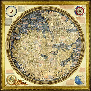
The Fra Mauro map is a map of the world made around 1450 by the Italian (Venetian) cartographer Fra Mauro, which is “considered the greatest memorial of medieval cartography." It is a circular planisphere drawn on parchment and set in a wooden frame that measures over two by two meters. Including Asia, the Indian Ocean, Africa, Europe, and the Atlantic, it is orientated with south at the top. The map is usually on display in the Biblioteca Nazionale Marciana in Venice in Italy.
Angelino Dulcert, probably the same person known as Angelino de Dalorto, and whose real name was probably Angelino de Dulceto or Dulceti or possibly Angelí Dolcet, was an Italian-Majorcan cartographer.

Pedro Reinel was a Portuguese cartographer. Between 1485 and 1519 Reinel served three Portuguese kings: João II, Manuel I and João III. He and his son, Jorge Reinel, were among the most renowned cartographers of their era, a period when European knowledge of geography and cartography were expanding rapidly. There is some evidence he was of African descent. Historian Rafael Moreira believes Reinel's father was an ivory carver brought from West Africa to serve in the royal workshops.

Portolan charts are nautical charts, first made in the 13th century in the Mediterranean basin and later expanded to include other regions. The word portolan comes from the Italian portolano, meaning "related to ports or harbors", and which since at least the 17th century designates "a collection of sailing directions".

The Padrón Real, known after 2 August 1527 as the Padrón General, was the official and secret Spanish master map used as a template for the maps present on all Spanish ships during the 16th century. It was kept in Seville, Spain by the Casa de Contratación. Ship pilots were required to use a copy of the official government chart, or risk the penalty of a 50 doblas fine. The map probably included a large-scale chart that hung on the wall of the old Alcázar of Seville. Well-known official cartographers and pilots who contributed to and used the map included Amerigo Vespucci, Diogo Ribeiro, Sebastian Cabot, Alonzo de Santa Cruz, and Juan Lopez de Velasco.

The Padrão Real or "Royal Register" was the official and quasisecret Portuguese master map during the Age of Exploration, used as a template for the maps of all official Portuguese expeditions. It formed the complete record of Portuguese discoveries both public and secret. First compiled under Henry the Navigator, it was later held and expanded by the Casa da Índia in the Ribeira Palace in Lisbon, Portugal. It was hung from the ceiling of the Casa da Índia's Division of Maps, protected from foreign and commercial spies but sometimes available to the era's scientific elite and copied for navigators in royal service.
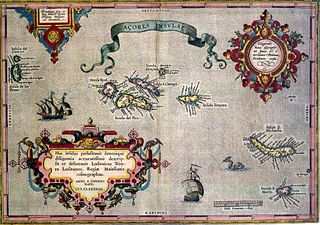
The following article describes the history of the Azores, an archipelago composed of nine volcanic islands in the Macaronesia region of the North Atlantic Ocean, about 1,400 km (870 mi) west of Lisbon, about 1,500 km (930 mi) northwest of Morocco, and about 1,930 km (1,200 mi) southeast of Newfoundland, Canada.

"Majorcan cartographic school" is the term coined by historians to refer to the collection of predominantly Jewish cartographers, cosmographers and navigational instrument-makers and some Christian associates that flourished in Majorca in the 13th, 14th and 15th centuries until the expulsion of the Jews. The label is usually inclusive of those who worked in Catalonia. The Majorcan school is frequently contrasted with the contemporary Italian cartography school.

Pietro Vesconte was a Genoese cartographer and geographer. A pioneer of the field of the portolan chart, he influenced Italian and Catalan mapmaking throughout the fourteenth and fifteenth centuries. He appears to have been the first professional mapmaker to sign and date his works regularly.

Giovanni da Carignano, or Johannes de Mauro de Carignano, was a priest and a pioneering cartographer from Genoa.
Gabriel de Vallseca, also referred to as Gabriel de Valseca and Gabriel de Valsequa was a cartographer of Jewish descent connected to the Majorcan cartographic school. His most notable map is the portolan of 1439, containing the first depiction of the recently-discovered Azores islands.
Domenico and Francesco Pizzigano, known as the Pizzigani brothers, were 14th-century Venetian cartographers. Their surname is sometimes given as Pizigano in older sources.

Zuane Pizzigano, was a 15th-century Venetian cartographer. He is the author of a famous 1424 portolan chart, the first known to depict the phantom islands of the purported Antillia archipelago, in the north Atlantic Ocean.
The island of Satanazes is a legendary island once thought to be located in the Atlantic Ocean, and depicted on many 15th-century maps.
The Medici-Laurentian Atlas, also known simply as the Medici Atlas, is an anonymous 14th-century set of maps, probably composed by a Genoese cartographer and explicitly dated 1351, although most historians believe it was composed, or at least retouched, later. The atlas is currently held by the Biblioteca Medicea Laurenziana in Florence, Italy.

Guillem Soler, sometimes given as Guillelmus Soleri, Guillermo Soler and Guglielmo Soleri, was a Majorcan cartographer of the 14th century.
Battista Beccario, also known as Baptista Beccharius, was a 15th-century Genoese cartographer.

The Freducci map is an Italian portolan chart of the Atlantic Ocean depicting portions of both the Old and New Worlds, drafted in Ancona in 1514–1515 or in the first half of the 16th century by Conte di Ottomanno Freducci. It is regarded as the earliest map of Florida, and one of the earliest non-Amerindian maps of northern Central America. It is now held at the Archivio di Stato di Firenze in Florence.
