Bavaria, officially the Free State of Bavaria, is a state in the southeast of Germany. With an area of 70,550.19 km2 (27,239.58 sq mi), it is the largest German state by land area, comprising roughly a fifth of the total land area of Germany. With over 13,08 million inhabitants, it is the second most populous German state, behind only North Rhine-Westphalia, but due to its large land area, its population density is below the German average. Major cities include Munich, Nuremberg, and Augsburg.

Franconia is a region of Germany, characterised by its culture and East Franconian dialect . Franconia is made up of the three Regierungsbezirke of Lower, Middle and Upper Franconia in Bavaria, the adjacent, Franconian-speaking South Thuringia, south of the Thuringian Forest—which constitutes the language boundary between Franconian and Thuringian—and the eastern parts of Heilbronn-Franconia in Baden-Württemberg.

The cuisine of Germany consists of many different local or regional cuisines, reflecting the country's federal history. Germany itself is part of the larger cultural region of Central Europe, sharing many culinary traditions with neighbouring countries such as Poland and the Czech Republic. In Northern Europe, in Denmark more specifically, the traditional Danish cuisine had also been influenced by German cuisine in the past, hence several dishes being common between the two countries.

The Main is the longest tributary of the Rhine. It rises as the White Main in the Fichtel Mountains of northeastern Bavaria and flows west through central Germany for 525 kilometres (326 mi) to meet the Rhine below Rüsselsheim, Hesse. The cities of Mainz and Wiesbaden are close to the confluence.
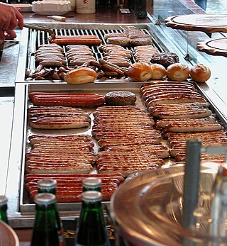
Bratwurst is a type of German sausage made from pork or, less commonly, beef or veal. The name is derived from the Old High German Brätwurst, from brät-, finely chopped meat, and Wurst, sausage, although in modern German it is often associated with the verb braten, to pan fry or roast. Beef and veal are usually incorporated amongst a blend often including pork. Beef or veal is usual in halal and kosher Bratwurst sausages, which never include pork for religious reasons.

The Bavarian Forest is a wooded, low-mountain region in Bavaria, Germany that is about 100 kilometres long. It runs along the Czech border and is continued on the Czech side by the Bohemian Forest. Most of the Bavarian Forest lies within the province of Lower Bavaria, but the northern part lies within Upper Palatinate. In the south it reaches the border with Upper Austria.
The 49th parallel north is a circle of latitude that is 49° north of Earth's equator. It crosses Europe, Asia, the Pacific Ocean, North America, and the Atlantic Ocean.

Weißwurst, literally 'white sausage'; Bavarian: Weißwuascht) is a traditional Bavarian sausage made from minced veal and pork back bacon. It is usually flavored with parsley, lemon, mace, onions, ginger and cardamom, although there are some variations. Then the mixture is stuffed into pork casings and separated into individual sausages measuring about 10 to 12 centimetres in length and 3–4 cm in thickness.

Bavarians are an ethnographic group of Germans of the Bavaria region, a state within Germany. The group's dialect or speech is known as the Bavarian language, native to Altbayern, roughly the territory of the Electorate of Bavaria in the 17th century.

Alamannia, or Alemania, was the kingdom established and inhabited by the Alemanni, a Germanic tribal confederation that had broken through the Roman limes in 213.

Europe is traditionally defined as one of seven continents. Physiographically, it is the northwestern peninsula of the larger landmass known as Eurasia ; Asia occupies the centre and east of this continuous landmass. Europe's eastern frontier is usually delineated by the Ural Mountains in Russia, which is the largest country by land area in the continent. The southeast boundary with Asia is not universally defined, but the modern definition is generally the Ural River or, less commonly, the Emba River. The boundary continues to the Caspian Sea, the crest of the Caucasus Mountains, and on to the Black Sea. The Bosporus, the Sea of Marmara, and the Dardanelles conclude the Asian boundary. The Mediterranean Sea to the south separates Europe from Africa. The western boundary is the Atlantic Ocean. Iceland is usually included in Europe because it is over twice as close to mainland Europe as mainland North America. There is ongoing debate on where the geographical centre of Europe falls.

Central or Middle Bavarian form a subgroup of Bavarian dialects in large parts of Austria and the German state of Bavaria along the Danube river, on the northern side of the Eastern Alps. They are spoken in the 'Old Bavarian' regions of Upper Bavaria, Lower Bavaria and in the adjacent parts of the Upper Palatinate region around Regensburg, in Upper and Lower Austria, in Vienna, in the state of Salzburg, as well as in the northern and eastern parts of Styria and Burgenland. Before 1945 and the expulsions of the Germans, it was also spoken in Hungary and southern Bohemia and Moravia. It also influenced Austrian German.
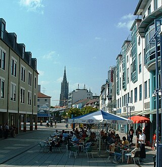
Neu-Ulm is the seat of the Neu-Ulm district and a town in Swabia, Bavaria. Neighbouring towns include Ulm, Senden, Pfaffenhofen an der Roth, Holzheim, Nersingen and Elchingen. The population is 58,978.

In anthropology and geography, a cultural area, cultural region, cultural sphere, or culture area refers to a geography with one relatively homogeneous human activity or complex of activities (culture). Such activities are often associated with an ethnolinguistic group and with the territory it inhabits. Specific cultures often do not limit their geographic coverage to the borders of a nation state, or to smaller subdivisions of a state.
The Limes Germanicus, or 'Germanic Limes', is the name given in modern times to a line of frontier fortifications that bounded the ancient Roman provinces of Germania Inferior, Germania Superior and Raetia, dividing the Roman Empire and the unsubdued Germanic tribes from the years 83 to about 260 AD. The frontier used either a natural boundary such as a river or typically an earth bank and ditch with a wooden palisade and watchtowers at intervals, and a system of linked forts was built behind them.

Röstigraben is a term used to refer to the cultural boundary between German-speaking Switzerland and Romandy, the French-speaking parts. There is also the term Polentagraben, referring to the boundary between German-speaking cantons, and the Italian-speaking canton of Ticino.
Southern Germany is a region of Germany that included the areas in which Upper German dialects are spoken, which includes the stem duchies of Bavaria and Swabia in present-day Bavaria, Baden-Württemberg, and the southern portion of Hesse and Rhineland-Palatinate that were part of the Duchy of Franconia.

The Danube is the second-longest river in Europe, after the Volga in Russia. It flows through Central and Southeastern Europe, from the Black Forest south into the Black Sea. A large and historically important river, it was once a frontier of the Roman Empire. In the 21st century, it connects ten European countries, running through their territories or marking a border. Originating in Germany, the Danube flows southeast for 2,850 km (1,770 mi), passing through or bordering Austria, Slovakia, Hungary, Croatia, Serbia, Romania, Bulgaria, Moldova, and Ukraine. Among the many cities on the river are four national capitals: Vienna, Bratislava, Budapest, and Belgrade. Its drainage basin amounts to 817,000 km2 (315,000 sq mi) and extends into nine more countries.
Germany is a country in Central and Western Europe that stretches from the Alps, across the North European Plain to the North Sea and the Baltic Sea. It is the second-most populous country in Europe after Russia, and is seventh-largest country by area in the continent. The area of Germany ranked 63rd and covers 357,600 km2 (138,070 sq mi), consisting of 349,250 km2 (134,846 sq mi) of land and 8,350 km2 (3,224 sq mi) of waters, smaller than Japan but larger than Republic of the Congo.