Welaunee Plantation, Florida

Last updated
Location of Weelaunee Plantation in 1947. Weelaunee Plantation.png
Location of Weelaunee Plantation in 1947.

Welaunee Plantation was a large quail hunting plantation located in central Leon County, Florida, United States established by Udo M. Fleischmann.

A quail hunting plantation is a large tract of land typically with a natural wooded and grass habitat for the purpose of recreational hunting of bobwhite quail.

Leon County, Florida County in Florida, United States

Leon County is a county located in the Panhandle of the U.S. state of Florida. It was named after the Spanish explorer Juan Ponce de León. As of 2017 Census estimates, the population was 290,292.

Florida State of the United States of America

Florida is the southernmost contiguous state in the United States. The state is bordered to the west by the Gulf of Mexico, to the northwest by Alabama, to the north by Georgia, to the east by the Atlantic Ocean, and to the south by the Straits of Florida. Florida is the 22nd-most extensive, the 3rd-most populous, and the 8th-most densely populated of the U.S. states. Jacksonville is the most populous municipality in the state and the largest city by area in the contiguous United States. The Miami metropolitan area is Florida's most populous urban area. Tallahassee is the state's capital.

Contents

History

Welaunee Plantation was created from land that once belonged to several cotton plantations and smaller farms. Known plantation lands that were purchased were R. A. Whitfield's The House Place Plantation, the southern tract of the James Kirksey Plantation, and Joseph John William's La Grange Plantation. [1]

James Kirksey Plantation human settlement in United States of America

The James A. Kirksey Plantation was a moderate plantation of 2,600 acres (1,100 ha) located in northwestern Leon County, Florida, United States, established by James A. Kirksey. In 1847 he served as mayor of Tallahassee. He had a large number of slaves.

La Grange Plantation human settlement in United States of America

La Grange Plantation was a large cotton plantation of 4,150 acres (1,680 ha) located in central Leon County, Florida, United States established by Joseph John Williams.

Location of Weelaunee Plantation in 1967. Welaunee Plantation 1967.png
Location of Weelaunee Plantation in 1967.

In 1952, Udo Fleischmann died leaving the property to his wife. Under Mrs. Fleischman, the property was used for Hereford cattle. In 1962, Mrs. Fleischmann died and her nephew, John W. Mettler, Jr. of New Brunswick, New Jersey and son of John Wyckoff Mettler the founder and president of Interwoven Stocking Company. Mettler increased the size of stock cattle to 500 head.

Hereford cattle breed of cattle

The Hereford is a British breed of beef cattle that originated in the county of Herefordshire, in the West Midlands of England. It has been exported to many countries, and there are more than five million purebred Hereford cattle in over fifty nations worldwide. The Hereford cattle export trade began from United Kingdom in 1817, starting in Kentucky, United States, spreading across the United States and Canada through Mexico to the great beef-raising countries of South America. Today, Hereford cattle dominate the world scene from Australasia to the Russian steppes. They can be found in Israel, Japan and throughout continental Europe and Scandinavia, in the temperate parts of Australia, Canada, the United States, Kazakhstan and Russia, in the centre and east of Argentina, in Uruguay, in Chile and New Zealand, where they make up the largest proportion of registered cattle. They are found all around Brazil and they are also found in some Southern African countries. They originally found great popularity among ranchers of the American Southwest, testament to the hardiness of the breed; while originating in cool, moist Britain, they have proven to thrive in much harsher climates on nearly every continent.

New Brunswick, New Jersey City in Middlesex County, New Jersey, U.S.

New Brunswick is a city in Middlesex County, New Jersey, United States, in the New York City metropolitan area. The city is the county seat of Middlesex County, and the home of Rutgers University. New Brunswick is on the Northeast Corridor rail line, 27 miles (43 km) southwest of Manhattan, on the southern bank of the Raritan River. As of 2016, New Brunswick had a Census-estimated population of 56,910, representing a 3.1% increase from the 55,181 people enumerated at the 2010 United States Census, which in turn had reflected an increase of 6,608 (+13.6%) from the 48,573 counted in the 2000 Census. Due to the concentration of medical facilities in the area, including Robert Wood Johnson University Hospital and Saint Peter's University Hospital, as well as Rutgers, The State University of New Jersey's Robert Wood Johnson Medical School, New Brunswick is known as both the Hub City and the Healthcare City. The corporate headquarters and production facilities of several global pharmaceutical companies are situated in the city, including Johnson & Johnson and Bristol-Myers Squibb.

In 1966 purchased 694 acres (2.81 km2) from his aunt, Mrs. Alfred B. Maclay. In 1967 he purchased the last acreage of Sunny Hill Plantation totaling 6,000 acres (24 km2).

Sunny Hill Plantation Hunting plantation in Florida, USA

Sunny Hill Plantation was a large hunting plantation in northern Leon County, Florida.

Recent history

Welaunee Plantation falls within the Miccosukee Greenway project. This greenway preserves the plantation, a vast pie shaped area between Miccosukee and Centerville Roads, is still not developed. The greenway plan was carefully carried out through years of careful negotiation between the Trust for Public Land, Leon County and the Welaunee's owners preserves the Miccosukee and Centerville canopy roads. By providing a right of way transportation corridor for Welaunee Boulevard, the greenway anticipates the transportation problems associated with connecting thousands of Welaunee Plantation and other northeastern residents to Tallahassee's center. [2]

Related Research Articles

Bradfordville, Florida unincorporated community in northern Leon County, Florida, USA

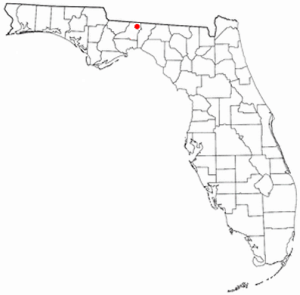
Bradfordville is an unincorporated community in northern Leon County, Florida, United States. It is 8 miles (13 km) north of Tallahassee and south of the Florida/Georgia state line by 8 miles (13 km) at the intersection of US 319 and County Road 0342. Elevation is 237 feet.

Miccosukee, Florida Unincorporated community in Florida, United States

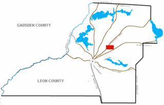
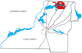
Miccosukee is a former small unincorporated community in northeastern Leon County, Florida, United States. It is located at the junction of County Road 59 and County Road 151. Miccosukee was a major center of the Miccosukee tribe, one of the tribes of the developing Seminole nation, during the 18th century.

Woodlawn (Leon County)

Woodlawn was a large plantation of 2,503 acres (1,013 ha) located in northern Leon County, Florida, United States established by Dr. Griffin Holland in 1834. Holland was married in 1839 to Margaret Whitaker.

W. G. Ponder Plantation human settlement in United States of America

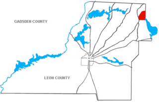
The William G. Ponder Plantation was a large cotton plantation of over 5,756 acres (2,329 ha) situated in northeastern Leon County, Florida, United States and established by William G. Ponder.

Chemonie Plantation human settlement in United States of America

Chemonie Plantation was a medium-sized cotton plantation of 1,840 acres (740 ha) in northern Leon County, Florida, United States established by Hector Braden.

House Place Plantation human settlement in United States of America

The House Place Plantation was a small cotton plantation of 1,800 acres (730 ha) located in central Leon County, Florida, United States established by R.A. Whitfield.

Southwood Plantation human settlement in United States of America

Southwood Plantation was a large cotton plantation of 5,000 acres (20 km2) located in southern Leon County, Florida, United States and owned by George Taliafero Ward.

Goodwood Plantation human settlement in Florida, United States of America

In 1824, in appreciation of the enormous service rendered to this country by the Marquis de Lafayette during the Revolutionary War, Congress voted to grant him a full township in the Florida Territory. This tract was called the Lafayette Land Grant and encompassed over 23,000 acres. While the Marquis never came to visit his property, he designated an agent to sell parcels of it on his behalf. The 2,400 acres upon which Goodwood Plantation was sited was purchased by Hardy Croom from the Lafayette Grant in 1834.

Orchard Pond Plantation human settlement in United States of America

Orchard Pond Plantation was a large cotton plantation originally of 8754 acres, (35½ km2) developed and owned in the 19th century by Richard Keith Call, attorney, planter and future Territorial Governor, in what is now northwestern Leon County, Florida, United States. In 1860 he owned 118 slaves to work the 1300 acres of improved land.

Live Oak Plantation was originally a small cotton plantation of 1,560 acres (630 ha) located in central Leon County, Florida, United States established by John Branch who arrived in Florida in 1832 and served as Florida Territorial Governor while living at Live Oak for 15 years.

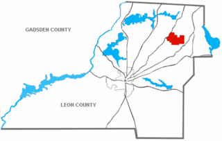
Miccosukee Plantation was a medium-sized cotton plantation of 2517 acres (10 km2) located in eastern Leon County, Florida. It was developed by John Miller, from Duplin County, North Carolina, who had migrated south during the period of Indian Removal in the 1830s. He depended on the labor of enslaved African Americans to develop the plantation and produce cotton as a commodity crop.

Barrow Hill Plantation human settlement in United States of America

Barrow Hill Plantation was a large cotton plantation of 3,990 acres (1,610 ha) located in central Leon County, Florida, United States. It was established by John S. Winthrop.

Ring Oak Plantation human settlement in United States of America

Ring Oak Plantation is a large quail hunting plantation located in northeast Leon County, Florida.

Loveridge Plantation human settlement in United States of America

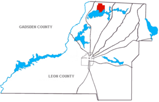
Loveridge Plantation is a quail hunting plantation located in northern Leon County, Florida, United States and established by George H. Love. Loveridge began as 1,000 acres (400 ha) on the northwest corner of Lake Miccosukee. In 1956, Love acquired an additional 10,500 acres (4,200 ha) of Sunny Hill Plantation from the estate of New Jersey Governor Walter E. Edge.

Foshalee Plantation human settlement in United States of America

Foshalee Plantation was a large quail hunting plantation located in northern Leon County, Florida, United States.

Norias Plantation human settlement in United States of America

Norias Plantation is a small quail hunting plantation located north of Lake Miccosukee in northeastern Leon County, Florida, United States.

Woodfield Springs Plantation human settlement in United States of America

Woodfield Spring Plantation was a large quail hunting plantation in northern Leon County, Florida, United States.

Tall Timbers Plantation (Florida) human settlement in United States of America

Tall Timbers Plantation was a quail hunting plantation located in northern Leon County, Florida, United States established by Edward Beadel in 1895.

References

  1. Paisley, Clifton, From Cotton To Quail: An Agricultural Chronicle of Leon County, Florida, 1860-1967, University of Florida Press, 1968. ISBN   978-0-8130-0718-2
  2. An interview with County Commissioner Thaell, Tallahassee Democrat, 3-22-1998.

Coordinates: 30°31′59″N84°08′25″W / 30.533137°N 84.140253°W / 30.533137; -84.140253

Geographic coordinate system Coordinate system

A geographic coordinate system is a coordinate system that enables every location on Earth to be specified by a set of numbers, letters or symbols. The coordinates are often chosen such that one of the numbers represents a vertical position and two or three of the numbers represent a horizontal position; alternatively, a geographic position may be expressed in a combined three-dimensional Cartesian vector. A common choice of coordinates is latitude, longitude and elevation. To specify a location on a plane requires a map projection.