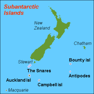
The New Zealand Subantarctic Islands comprise the five southernmost groups of the New Zealand outlying islands. They are collectively designated as a UNESCO World Heritage Site. Most of the islands lie near the southeast edge of the largely submerged continent centred on New Zealand called Zealandia, which was riven from Australia 60–85 million years ago and from Antarctica between 130 and 85 million years ago.

The Rouse Islands or Rouse Rocks are a small group of islands in the eastern part of Holme Bay in Antarctica, fringing the coast of Mac Robertson Land close south of Welch Island. The Rouse Islands have an elevation of 28 m (92 ft). The Rouse Islands were discovered on February 13, 1931, by the British Australian and New Zealand Antarctic Research Expedition (BANZARE) under Sir Douglas Mawson, who named them for E. J. Rouse of Sydney, who assisted the expedition with photographic equipment. The Rouse Islands have since been found to be islands.

Opaka Rocks are a group of rocks with the principal one situated 700 m (766 yd) north of Henfield Rock, 3.44 km (2.14 mi) east of Pordim Islands and 4.79 km west by south of Mellona Rocks off the north coast of Robert Island, South Shetland Islands. Bulgarian early early mapping in 2009. Named after the town of Opaka in northeastern Bulgaria.

Voluyak Rocks is a chain of rocks off the north coast of Greenwich Island in the South Shetland Islands, Antarctica situated 400 m (440 yd) north of Pavlikeni Point. Extending 1.9 km (1.2 mi) in southeast-northwest direction.
Rabisha Rocks is a group of rocks off the north coast of Greenwich Island in the South Shetland Islands, Antarctica situated 1.5 km (0.93 mi) northeast of Voluyak Rocks, 1.3 km (0.81 mi) north of Kabile Island and 1.8 km (1.12 mi) west of Ongley Island.
Tvarditsa Rocks is a group of rocks off the north coast of Greenwich Island in the South Shetland Islands, Antarctica situated 1.9 km (1.2 mi) northeast of Ongley Island, 1.3 km (0.81 mi) southwest of Stoker Island and 2.6 km (1.6 mi) west of Sierra Island.
Buchino Rocks is a group of rocks off the north coast of Greenwich Island in the South Shetland Islands, Antarctica situated 1.5 km (0.93 mi) northwest of Stoker Island, 1.6 km (0.99 mi) southeast of Romeo Island and 1.9 km (1.2 mi) north-northwest of Tvarditsa Rocks.

Sally Rocks is a small group of rocks trending southwestwards in South Bay just off the west coast of Hurd Peninsula, Livingston Island in the South Shetland Islands, Antarctica.

Lynx Rocks is a group of rocks in southwestern Hero Bay on the north side of Livingston Island in the South Shetland Islands, Antarctica. The area was visited by early 19th century sealers operating from nearby Blythe Bay.
The Tryne Islands are a group of numerous small Antarctic islands and rocks, about 7 km (4 mi) in extent, forming the western limit of Tryne Bay and Tryne Sound at the north-eastern end of the Vestfold Hills. The islands were mapped by Norwegian cartographers from aerial photographs taken by the Lars Christensen Expedition (1936–37) and named Trynøyane.
Milev Rocks is the group of rocks off the north coast of Robert Island in the South Shetland Islands, Antarctica, situated east of Henfield Rock, south-southwest of Orsoya Rocks and southwest of Mellona Rocks, and extending 1.5 km (0.93 mi) in east-west direction and 600 m (656 yd) in north-south direction.
Orsoya Rocks is the group of rocks off the north coast of Robert Island in the South Shetland Islands, Antarctica, situated west-northwest of Mellona Rocks, north-northeast of Milev Rocks and east-northeast of Opaka Rocks, and extending 650 m in northwest-southeast direction and 500 m in northeast-southwest direction.
Skrino Rocks is the chain of rocks off the east coast of Robert Island in the South Shetland Islands, Antarctica, extending 570 m (623 yd) in east-west direction.
Alepu Rocks is the group of rocks off the east coast of Robert Island in the South Shetland Islands, Antarctica, situated in an area with a diameter of 380 m (416 yd).
The Klung Islands are a group of small islands lying 1 kilometre (0.5 nmi) east of Welch Island and the Welch Rocks in the northeastern part of Holme Bay, Antarctica. They were mapped by Norwegian cartographers from aerial photographs taken by the Lars Christensen Expedition, 1936–37, and called Klungholmane. Klung Island is the largest island in the group.
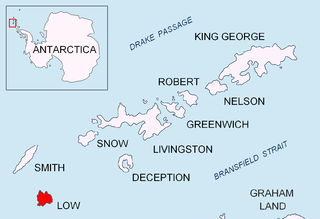
Lyutibrod Rocks is the chain of rocks off the northwest coast of Low Island in the South Shetland Islands extending 860 m in east-west direction.

Dlagnya Rocks are the several contiguous rocks in Zed Islands off Varna Peninsula, Livingston Island in the South Shetland Islands extending 540 m in north-south direction and 60 m wide. The area was visited by early 19th century sealers.
Goritsa Rocks are the two contiguous rocks in Zed Islands off Varna Peninsula, Livingston Island in the South Shetland Islands extending 330 m in northwest-southeast direction and 70 m wide. The area was visited by early 19th century sealers.

Pingvin Rocks is the group of rocks in Morton Strait off the northeast coast of Snow Island in the South Shetland Islands, Antarctica extending 670 m in west–east direction and 300 m in south–north direction. The area was visited by early 19th-century sealers.

