Related Research Articles

William von Moll Berczy was a German-born Upper Canada pioneer and painter. He is considered one of the co-founders of the Town of York, Upper Canada, now Toronto, Ontario, Canada.

Toronto Chinatowns are ethnic enclaves in Toronto, Ontario, Canada, with a high concentration of ethnic Chinese residents and businesses. These neighbourhoods are major cultural, social and economic hubs for the Chinese-Canadian communities of the region. In addition to Toronto, several areas in the Greater Toronto Area also hold a high concentration of Chinese residents and businesses.

Harbourfront is a neighbourhood on the northern shore of Lake Ontario within the downtown core of the city of Toronto, Ontario, Canada. Part of the Toronto waterfront, Harbourfront extends from Bathurst Street in the west, along Queens Quay, with its ill-defined eastern boundary being either Yonge Street or York Street. Its northern boundary is the Gardiner Expressway. Much of the district was former water lots filled in during the early 1900s to create a larger harbour district. After shipping patterns changed and the use of the Toronto harbour declined, the area was converted from industrial uses to a mixed-use district that is mostly residential and leisure.
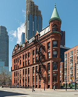
The Gooderham Building, also known as the Flatiron Building, is an historic office building at 49 Wellington Street East in Toronto, Ontario, Canada. It is located on the eastern edge of the city's Financial District in the St. Lawrence neighbourhood, wedged between Front Street and Wellington Street in Downtown Toronto, where they join up to form a triangular intersection. Completed in 1892, the red-brick edifice was an early example of a prominent flatiron building.

Spadina Avenue is one of the most prominent streets in Toronto, Ontario, Canada. Running through the western section of downtown, the road has a very different character in different neighbourhoods.

1 Spadina Crescent, also known as the Daniels Building, is an academic building home to the John H. Daniels Faculty of Architecture, Landscape, and Design at the University of Toronto in Toronto, Ontario, Canada. The building is situated in the centre of a roundabout of Spadina Avenue, north of College Street. Its location provides a picturesque vista looking north up Spadina Avenue; it is an axial view terminus for Spadina Avenue.
St. Andrew—St. Patrick was a provincial electoral district in Ontario, Canada, that returned Members of Provincial Parliament (MPPs) to the Legislative Assembly of Ontario at Queen's Park.

The Fashion District is a commercial and residential district in Downtown Toronto, Ontario, Canada. It is located between the intersection of Bathurst Street to the west, Spadina Avenue to the east, Queen Street West to the north and King Street to the south. Google Maps extends the district further east of Spadina Avenue to Peter Street.

Hughson Street is a Lower City collector road in Hamilton, Ontario, Canada. It starts at Charlton Avenue East at St. Joseph's hospital and runs north to Haymarket Street in the downtown where it's cut off by the Hamilton GO Transit station. Up to this point it is a two-way street. It then starts up again north of the station on Hunter Street East, where it then becomes a one-way street going north just past Barton Street East to Murray Street where it's cut off again by a parking lot for LIUNA Station. It then starts up again one block north past the CN railway tracks on Strachan Street and from this point onwards becomes a two-way street again that extends to the city's North End to the waterfront on Guise Street West, the site of the Canada Marine Discovery Centre and Pier 9.
Beasley is the name of a neighbourhood in the Lower City area of Hamilton, Ontario, Canada. The Beasley neighbourhood is bounded in the north by the Canadian National Railway tracks just north of Barton Street, James Street (west), Main Street (south) and Wellington Street (east).

The Discovery District is one of the commercial districts in Downtown Toronto, Ontario, Canada. It has a high concentration of hospitals and research institutions, particularly those related to biotechnology. The district is roughly bounded by Bloor Street on the north, Bay Street on the east, Dundas Street on the south, and Spadina Avenue on the west.

Clarence Square is a small park in downtown Toronto, Ontario, Canada, where Wellington Street West meets Spadina Avenue. It is a relatively quiet and shady park, with many large trees and a spacious grassy terrain. There are several benches and picnic tables scattered throughout and a drinking fountain in the centre.

The Hotel Waverly was a four-storey low-rise hotel in downtown Toronto. Opened in 1900, the hotel was built for J.J. Powell. It was one of the oldest Toronto hotels in continuous operation.

Trefann Court is a small neighbourhood in the eastern part of downtown Toronto, Ontario, Canada. It is located on the north side of Queen Street between Parliament Street and River Street. It extends north only a short distance to Shuter St.
St. Andrew's Playground is a small park in downtown Toronto. It is located at the 450 Adelaide Street West, at the northwest corner of Brant St and Adelaide. It has a playground for children and an off-leash area for dogs that is surrounded by a short fence, with an accessible water fountain for pets, children, and adults. A Heritage Toronto plaque in the northwest corner describing the history and significance of the park was installed in 2007.

South Hill is a neighbourhood in Toronto, Ontario, Canada. It is located north of downtown and covers the area west of Avenue Road, south of St. Clair Avenue, east of Spadina Road, and north of the Canadian Pacific railway tracks. The area is dominated by the steep hill of the former Lake Iroquois shoreline. The Nordheimer Ravine also cuts through the area, which is surrounded by Sir Winston Churchill Park. This park covers the northwestern portion of South Hill.

Turning loops of the Toronto streetcar system serve as termini and turnback points for streetcar routes in Toronto, Ontario, Canada. The single-ended streetcars require track loops in order to reverse direction. Besides short off-street track loops these can also be larger interchange points, having shelters and driver facilities, or be part of a subway station structure for convenient passenger interchange.

Following the Upper Canada Rebellion of 1837 Lieutenant Governor of Upper Canada Sir George Arthur directed the construction of a Sherbourne Blockhouse, and a ring of six other blockhouses -- to guard the approaches to Toronto in case there was another rebellion. The Sherbourne Blockhouse was located at the northern end of Sherbourne Street, at the current intersection with Bloor, just south of the Rosedale Ravine.
Draper Street is a street in downtown Toronto, Ontario, Canada. It is a north-south street located to the west of Spadina Avenue, from Front Street West north to Wellington Street. Draper Street is notable for its collection of 28 19th Century Second Empire-styled row cottages. The houses were designated by the City of Toronto government in the 1990s to have heritage status. The entire street is designated as a Heritage Conservation District as a way to preserve its heritage for posterity.

Berczy Park is a small park in downtown Toronto, Ontario, Canada. The park is triangular in shape, bounded by Scott, Front and Wellington streets. The park is bordered at its eastern tip, where Wellington and Front join, by the Gooderham Building, a heritage building that is an example of a "flatiron building". A widely admired mural graces the western facade of the building.
References
- 1 2 David Hains (2017-07-18). "Draper St.'s Dizzy the Cat gets a promenade dedicated to him". Toronto Star . Archived from the original on 2017-08-05. Retrieved 2019-06-05.
For years, the plump 13-year-old orange and white cat has been a popular fixture on Draper St. in downtown Toronto.
- ↑ Chardaé Jones (2018-06-21). "Cat Themed Wellington Cat Promenade Is Replacing The Addisons Residence". Love this city. Archived from the original on 2018-08-23. Retrieved 2019-06-05.
Don’t expect for the demolition to happen overnight because word has it that the 1,000 metre cat park won’t be ready until 2022.
- ↑ Taylor Simmons (2018-06-20). "Cat-themed parks to replace nightclub in Wellington Street West neighbourhood". CBC News . Archived from the original on 2018-08-02. Retrieved 2019-06-05.
- ↑ Lauren O'Neil (June 2018). "Popular Toronto nightclub to be demolished for cat themed park". Blog TO . Archived from the original on 2018-07-26. Retrieved 2019-06-05.
The Addisons Residence, a lounge-meets-club space on the quiet stretch of Wellington Street between Spadina and Bathurst, will officially be demolished to make way for the long-awaited "Wellington Cat Promenade" — one of two new, cat-themed public parks in downtown Toronto.