
Somerset, archaically Somersetshire is a ceremonial county in South West England. It is bordered by the Bristol Channel, Gloucestershire, and Bristol to the north, Wiltshire to the east and the north-east, Dorset to the south-east, and Devon to the south-west. The largest settlement is the city of Bath, and the county town is Taunton.
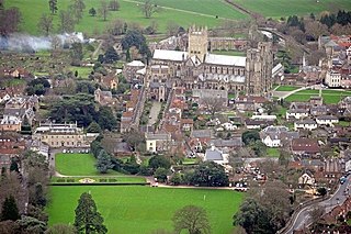
Wells is a cathedral city and civil parish in Somerset, located on the southern edge of the Mendip Hills, 21 miles (34 km) south-east of Weston-super-Mare, 22 mi (35 km) south-west of Bath and 23 mi (37 km) south of Bristol. Although the population recorded in the 2011 census was only 10,536, and with a built-up area of just 3.244 km2 (1.253 sq mi), Wells has had city status since medieval times, because of the presence of Wells Cathedral. Often described as England's smallest city, it is actually the second smallest to the City of London in area and population, but unlike London it is not part of a larger urban agglomeration.

Bridgwater is a historic market town and civil parish in Somerset, England. The town had a population of 41,276 at the 2021 census. Bridgwater is at the edge of the Somerset Levels, in level and well-wooded country. The town lies along both sides of the River Parrett; it has been a major inland port and trading centre since the industrial revolution. Most of its industrial bases still stand today. Its larger neighbour, Taunton, is linked to Bridgwater via a canal, the M5 motorway and the GWR railway line.

Glastonbury is a town and civil parish in Somerset, England, situated at a dry point on the low-lying Somerset Levels, 23 miles (37 km) south of Bristol. The town had a population of 8,932 in the 2011 census. Glastonbury is less than 1 mile (2 km) across the River Brue from Street, which is now larger than Glastonbury.
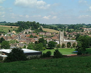
Shepton Mallet is a market town and civil parish in Somerset, England, some 16 miles southwest of Bath, 18 miles south of Bristol and five miles east of Wells. It had an estimated population of 10,810 in 2019. Mendip District Council was based there. The Mendip Hills lie to the north and the River Sheppey runs through the town, as does the route of the Fosse Way, the main Roman road between north-east and south-west England. There is evidence of Roman settlement. Its listed buildings include a medieval parish church. Shepton Mallet Prison was England's oldest, but closed in March 2013. The medieval wool trade gave way to trades such as brewing in the 18th century. It remains noted for cider production. It is the closest town to the Glastonbury Festival and nearby the Royal Bath and West of England Society showground.

Taunton is the county town of Somerset, England. It is a market town and has a minster church. Its population in 2011 was 64,621. Its thousand-year history includes a 10th-century monastic foundation, owned by the Bishops of Winchester, which was rebuilt as Taunton Castle by the Normans in the 12th century. Parts of the inner ward house were turned into the Museum of Somerset and Somerset Military Museum. For the Second Cornish uprising of 1497, Perkin Warbeck brought an army of 6,000; most surrendered to Henry VII on 4 October 1497. On 20 June 1685 in Taunton the Duke of Monmouth crowned himself King of England in a rebellion, defeated at the Battle of Sedgemoor. Judge Jeffreys led the Bloody Assizes in the Castle's Great Hall.

North Petherton is a town and civil parish in Somerset, England, situated on the edge of the eastern foothills of the Quantocks, and close to the edge of the Somerset Levels. The town has a population of 6,730 as of 2014. The parish includes Hamp, Melcombe, Shearston, Woolmersdon and Huntworth.

Ilchester is a village and civil parish, situated on the River Yeo or Ivel, five miles north of Yeovil, in the English county of Somerset. Originally a Roman town, and later a market town, Ilchester has a rich medieval history and was a notable settlement in the county; around the 12th and 13th centuries it was effectively the county town. It had, however, declined in size and importance by the beginning of the 18th century, and the last markets were held in 1833. In 1889 the historic corporation that had governed the town was dissolved.

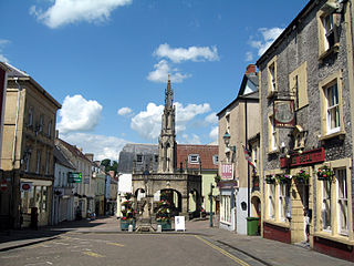
Axbridge is a town in Somerset, England, on the River Axe, near the southern edge of the Mendip Hills. Its population according to the 2011 census was 2,057.

Portishead is a town and civil parish in the North Somerset unitary authority area, in the county of Somerset, England. With a population of 26,366 at the 2021 Census, the town is located on the Severn Estuary opposite Cardiff and Newport in Wales. The town is 8 miles (13 km) to the west of Bristol and 18 miles northeast of Weston-super-Mare.

Somerton is a town and civil parish in the English county of Somerset. It gave its name to the county and was briefly, around the start of the 14th century, the county town, and around 900 was possibly the capital of Wessex. It has held a weekly market since the Middle Ages, and the main square with its market cross is today popular with visitors. Situated on the River Cary, approximately 8.8 miles (14.2 km) north-west of Yeovil, Somerton has its own town council serving a population of 4,697 as of 2011.

Minehead is a coastal town and civil parish in Somerset, England. It lies on the south bank of the Bristol Channel, 21 miles (34 km) north-west of the county town of Taunton, 12 miles (19 km) from the boundary with the county of Devon and in proximity of the Exmoor National Park.
Chard is a town and a civil parish in the English county of Somerset. It lies on the A30 road near the Devon and Dorset borders, 15 miles (24 km) south west of Yeovil. The parish has a population of approximately 14,000 and, at an elevation of 121 metres (397 ft), Chard is the southernmost and one of the highest towns in Somerset. Administratively Chard forms part of the district of South Somerset.

Wellington is a market town in Somerset, England. It is situated 7 miles (11 km) south west of Taunton, near the border with Devon, which runs along the Blackdown Hills to the south of the town. The town had a population of 16,669, which includes the residents of the parish of Wellington Without, and the villages of Tone and Tonedale.

Castle Cary is a market town and civil parish in south Somerset, England, 5 miles (8 km) north west of Wincanton and 8 miles (12.9 km) south of Shepton Mallet, at the foot of Lodge Hill and on the River Cary, a tributary of the Parrett.

Highbridge is a market town on the edge of the Somerset Levels near the mouth of the River Brue. It is in the county of Somerset, and is about 20 miles (32 km) northeast of Taunton, the county town of Somerset. No longer a market town, the market site is now a housing estate. Highbridge is about 7 miles (11 km) north of Bridgwater, the district's administrative centre. Highbridge closely neighbours Burnham-on-Sea, forming part of the combined parish of Burnham-on-Sea and Highbridge and shares a town council with the resort town. The 2001 Census recorded Highbridge's population as 5,986. In the 2011 Census the population of the town was included in the ward of Highbridge and Burnham Marine, which totalled 7,555.
Bruton is a market town, and civil parish in Somerset, England, on the River Brue and the A359 between Frome and Yeovil. It is 7 miles (11 km) south-east of Shepton Mallet, just south of Snakelake Hill and Coombe Hill, 10 miles (16 km) north-west of Gillingham and 12 miles (19 km) south-west of Frome. The town and ward have a population of 2,907. The parish includes the hamlets of Wyke Champflower and Redlynch.

Somerset is a county in the south west of England. It has a varied cultural tradition ranging from the Arthurian legends to The Wurzels, a band specialising in Scrumpy and Western music.

Fore Street in Chard, Somerset, England was built in the late 16th and early 17th century, following a fire which destroyed much of the town in 1577.

Tone Dale House is a Grade II listed country house built in 1801 or 1807 by Thomas Fox in Wellington, Somerset, England. Wellington lies 7 miles (11 km) west of Taunton in the vale of Taunton Deane, 1 mile (1.6 km) from the Devon border. Tone Dale House, also known as House of Fox, offers views of Somerset which include the Quantock hills to the north and the Blackdown Hills to the south.

