Wellington town belt

Last updated

Removing wind-thrown logs Tinakori Hill or Te Ahumairangi Hill Logging the Town Belt, Wellington 18 April 2005 01.jpg
Removing wind-thrown logs Tinakori Hill or Te Ahumairangi Hill

Wellington town belt and Outer green belt is a pair of strips of tree-filled wilderness spaces near and around central Wellington, New Zealand's capital city. The inner strip, the town belt, is an elongated U-shape. It was set aside by the city's founders in 1840. It is now about two-thirds of its original area. Portions have been used for purposes like Wellington's Public Hospital and Wellington Botanic Garden.

Wellington Capital city of New Zealand

Wellington is the capital and second most populous urban area of New Zealand, with 418,500 residents. It is located at the south-western tip of the North Island, between Cook Strait and the Remutaka Range. Wellington is the major population centre of the southern North Island, and is the administrative centre of the Wellington Region, which also includes the Kapiti Coast and the Wairarapa. It is the world's southernmost capital of a sovereign state. Wellington features a temperate maritime climate, and is the world's windiest city by average wind speed.

Capital of New Zealand

Wellington has been the capital of New Zealand since 1865. New Zealand's first capital city was Old Russell (Okiato) in 1840–41. Auckland was the second capital from 1841 until 1865, when Parliament was permanently moved to Wellington after an argument that persisted for a decade. As the members of parliament could not agree on the location of a more central capital, Wellington was decided on by three Australian commissioners.

Wellington Hospital, New Zealand Hospital in Wellington, New Zealand

Wellington Hospital is the main hospital in Wellington, New Zealand, located south of the city centre in the suburb of Newtown. It is the main hospital run by Capital & Coast District Health Board (C&CDHB), which serves Wellington City, Porirua and the Kapiti Coast District. Lower Hutt and Upper Hutt are served by the separate Hutt Valley DHB and a separate hospital, Hutt Hospital, in the Lower Hutt suburb of Boulcott.

Contents

New Zealand Company

At the time of British settlement of Wellington immigrants came from areas with overcrowded cities and it was seen to be important that all citizens should have access to green spaces. The New Zealand Company instructed its surveyor to include "a broad belt of land, which you will declare that the Company intends to be public property, on condition that no buildings ever be erected upon it". [1] The initial space set aside covered 625 hectares but by the year 2000 it had fallen to 425 hectares. [2] It is owned by Wellington City Council.

New Zealand Company company formed for the purpose of colonising New Zealand

The New Zealand Company, chartered in the United Kingdom, was a company that existed in the first half of the 1800s on a business model focused on the systematic colonisation of New Zealand. The company was formed to carry out the principles devised by Edward Gibbon Wakefield, who envisaged the creation of a new-model English society in the southern hemisphere. Under Wakefield’s model, the colony would attract capitalists who would then have a ready supply of labour—migrant labourers who could not initially afford to be property owners, but who would have the expectation of one-day buying land with their savings.

Wellington City Council territorial authority in the Wellington urban area of New Zealand

Wellington City Council is a territorial authority in New Zealand, governing the country's third-largest city by population, behind Auckland and Christchurch. Wellington City consists of the central historic town and certain additional areas within the Wellington metropolitan area, extending as far north as Linden and covering rural areas such as Makara and Ohariu. The city adjoins Porirua in the north and Hutt City in the north-east. It is one of nine territorial authorities in the Wellington Region.

Overview Access way Mount Victoria Park (816376619).jpg
Overview
Entrance to a walkway Mount Victoria Park (8323933690).jpg
Entrance to a walkway
The Start of our Walk (5158337).jpg

The strip runs from Mount Victoria south to Mount Albert, which is between Berhampore and Island Bay, and then north to Te Ahumairangi Hill or Tinakori Hill.

Mount Victoria, Wellington Suburb in Wellington City, New Zealand

Mount Victoria is a prominent hill 196 metres (643 ft) high immediately to the east of central Wellington, New Zealand. About 4 kilometres due south is a spur named Mount Albert and the two are linked by a ridge. Mount Victoria's residential area is on its north-western slopes.

Berhampore, New Zealand Suburb in on City, New Zealand

Berhampore is a suburb of Wellington, New Zealand. It lies towards the south of the city, seven kilometres from the city centre, and two kilometres from the coast of Cook Strait. It is surrounded by the suburbs of Vogeltown, Newtown, Melrose, Island Bay, Kingston, and Mornington. The suburb was named after Berhampore in Bengal, one of the battlefields at the start of the Battle of Plassey of 1757. Also surrounding Berhampore is the Berhampore Golf Course as well as a very extensive green belt with many walkways and tracks connecting outlying areas. The suburb also boasts some of Wellington's best all weather sports fields, on Adelaide Road and the national hockey stadium. Alongside the golf course there is a skateboard/bmx park, right by a kids mountain bike track. Berhampore School opened in 1915.

Island Bay, New Zealand Suburb in Wellington City, New Zealand

Island Bay is a coastal suburb of Wellington, the capital of New Zealand, situated 5 km south of the city centre.

Outer green belt

The outer strip of some 5,000 hectares includes some private land. It was first proposed in 1976 to protect the skyline, wildlife and remaining native forest. Some sites included are:

Wrights Hill Fortress

Wrights Hill Fortress is a counter bombardment coastal artillery battery in the Karori suburb of Wellington, New Zealand. It was built between 1942 and 1947 and is predominantly underground, with numerous tunnels linking the war shelters, gun emplacements, magazines, plotting rooms and engine room - which are, at some points, over 50 feet underground. The fort was intended to house three 9.2" Mk. XV guns, but only two guns were installed and the fort never saw action. After World War II was over, fort commanders fired both of the guns. The fall of the shot was observed in Cook Strait and these test firings were deemed a success. In 1960, somewhat ironically, both of the guns were sold to the Japanese as scrap metal, the very nation Wrights Hill Fortress was constructed to defend Wellington against. The design of the fort is similar to the Stony Batter and Whangaparaoa 9.2" Mk. XV batteries, near Auckland.

Makara Peak Mountain Bike Park

In 1998 the Wellington City Council set aside 200 hectares of retired farmland in Karori southwest of Wellington, New Zealand, for a mountain bike park. Development of the Makara Peak Mountain Bike Park began almost immediately with volunteer work parties planting trees, removing pest animals and digging new tracks.

Mount Kaukau, is in Wellington, New Zealand on the western side of the Wellington harbour near Johnsonville and Khandallah. The summit is 445 metres above sea level and is the most visible high point in the Wellington landscape further accentuated by Wellington's main television transmitter tower the Kordia TV transmitter mast, which stands 122m tall. There is also a compass pedestal placed at the top. The city, harbour and the Rimutaka and Tararua Ranges can be viewed from the summit. On a clear day Mt. Tapuaeoenuku and the Bryant Range in the South Island may be seen, whilst northwest is the Porirua Basin and the expanse of the Tasman Sea. Mount Kaukau is also a field trip for primary schools.

Related Research Articles

Aoraki / Mount Cook Mountain in the Southern Alps of New Zealand

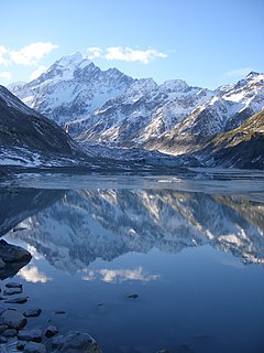
Aoraki / Mount Cook is the highest mountain in New Zealand. Its height since 2014 is listed as 3,724 metres, down from 3,764 m (12,349 ft) before December 1991, due to a rockslide and subsequent erosion. It lies in the Southern Alps, the mountain range which runs the length of the South Island. A popular tourist destination, it is also a favourite challenge for mountain climbers. Aoraki / Mount Cook consists of three summits, from South to North the Low Peak, Middle Peak and High Peak. The summits lie slightly south and east of the main divide of the Southern Alps, with the Tasman Glacier to the east and the Hooker Glacier to the southwest.

Geography of New Zealand

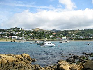
New Zealand is an island country located in the south-western Pacific Ocean, near the centre of the water hemisphere. It consists of a large number of islands, estimated around 600, mainly remnants of a larger land mass now beneath the sea. The two main islands by size are the North Island and the South Island, separated by the Cook Strait; the third-largest is Stewart Island, located 30 kilometres off the tip of the South Island across Foveaux Strait. The three largest islands stretch 1,500 kilometres across latitudes 34° to 47° south.

Palmerston North City in North Island, New Zealand

Palmerston North is a city in the North Island of New Zealand and the seat of the Manawatu-Wanganui region. Located in the eastern Manawatu Plains, the city is near the north bank of the Manawatu River, 35 km (22 mi) from the river's mouth, and 12 km (7 mi) from the end of the Manawatu Gorge, about 140 km (87 mi) north of the capital, Wellington. Palmerston North is the country's seventh-largest city and eighth-largest urban area, with an urban population of 86,600.

Department of Conservation (New Zealand) New Zealand government agency

The Department of Conservation (DOC) is the public service department of New Zealand charged with the conservation of New Zealand's natural and historical heritage.

Ellerslie, New Zealand Suburb in Auckland Council, New Zealand

Ellerslie is a suburb of the city of Auckland, in the North Island of New Zealand. It is a small but dynamic town centre with a strong community spirit. Ellerslie lies seven kilometres to the southeast of the city centre, close to State Highway 1, and has a population of 8667. Administratively, Ellerslie forms part of the Orakei Local Board, which also includes the suburbs of Orākei, Mission Bay, Kohimarama, Saint Heliers, Glendowie, Saint Johns, Meadowbank and Remuera. To the west, Ellerslie borders on the One Tree Hill area and Cornwall Park. Largely a residential suburb, the area is arguably best-known as the site of Auckland's main horse-racing venue, Ellerslie Racecourse, as well as the original site of the Ellerslie Flower Show.

Hataitai Suburb in Wellington City, New Zealand

Hataitai is an inner-city suburb of Wellington, the capital of New Zealand, 3.5 kilometres southeast of the city centre. The suburb extends over the southeastern flank of Mount Victoria and down a valley between the Town Belt and a ridge along the shoreline of Evans Bay. Hataitai is bounded by Hepara Street, Grafton Road and the suburb of Roseneath in the north, Wellington Harbour in the east, Cobham Drive, Wellington Road and Crawford Road in the south, and Alexandra Road in the west.

Brooklyn, New Zealand Suburb in Wellington City, New Zealand

Brooklyn is a suburb of Wellington, the capital city of New Zealand.

Mount Hikurangi (Gisborne District) mountain in New Zealand

Mount Hikurangi is a 1,752 m (5,748 ft) peak in the eastern corner of New Zealand's North Island, about 80 kilometres (50 mi) north of Gisborne, and 50 kilometres (31 mi) southwest of the East Cape Lighthouse. On a spur of the Raukumara Range in the Waiapu Valley, it is the North Island's highest non-volcanic peak.

Aro Valley Suburb in Wellington City, New Zealand

The Aro Valley forms a small inner-city suburb of Wellington in New Zealand. It takes its name from the stream which originally flowed where modern Epuni Street is. The stream's Maori name was originally Wai-Mapihi, but it was commonly called Te Aro due to it running through the Te Aro flat.

Protected areas of New Zealand areas protected in New Zealand to preserve their environmental, historical or cultural value

Protected areas of New Zealand receive protection to preserve their environmental, historical or cultural value. The method and aims of protection vary according to the importance of the resource and whether it has public or private status. Nearly 30 percent of the land mass of New Zealand is in public ownership and has some degree of protection; these areas include conservation parks, mainland islands, island reserves, marine reserves, and national parks.

Sylvia Park

Sylvia Park is a large business park and shopping centre in the Auckland suburb of Mount Wellington in New Zealand. Less commonly known, the area around the centre is also called Sylvia Park. The area is located adjacent to two major interchanges of the Auckland Southern Motorway – the South Eastern Highway and Mount Wellington Highway.

Te Ahumairangi Hill

Te Ahumairangi Hill is a hill running for 38 hectares through the Town Belt of Wellington, New Zealand. It was renamed Te Ahumairangi Hill as part of the Port Nicholson Block Claims Settlement Act 2009. The suburb of Wadestown lies to the north, with Wilton, and Northland to the west and south-west. Te Ahumairangi lies within Thorndon which continues to its south-east.

Rangitāne Māori iwi (tribe) in Aotearoa New Zealand

Rangitāne is a Māori iwi (tribe). Their rohe (territory) is in the Manawatū, Horowhenua, Wairarapa and Marlborough areas of New Zealand.

Waiwhetū Suburb in Lower Hutt City, New Zealand

Waiwhetū is an eastern suburb of Lower Hutt in the Wellington Region situated in the south of the North Island of New Zealand.

Reclamation of Wellington Harbour

The reclamation of Wellington Harbour started in the 1850s, originally to increase the amount of usable flat land for Wellington city. Reclamations in the 1960s and 1970s were to meet the needs of container shipping (containerisation) and new cargo handling methods. Reclamation has added more than 155 hectares to Wellington.

Waiapu Valley Place in Gisborne Region, New Zealand

Waiapu Valley, also known as the Waiapu catchment, Waiapu River valley or simply Waiapu, is a valley in the north of the Gisborne Region on the East Coast of the North Island of New Zealand. It is the catchment area for the Waiapu River and its tributaries, and covers 1,734 square kilometres (670 sq mi). The Raukumara Range forms the western side of the valley, with Mount Hikurangi in the central west. The towns of Ruatoria and Tikitiki are in the north-east of the valley.

References

  1. City Parks and green spaces, Te Ara the Encyclopaedia of New Zealand, Quoted in Walter Cook, ‘Wellington’s town belt – a people’s park and a heritage for everyone. The 1991 Ian Galloway Memorial Lecture.’ Horticulture in New Zealand 2, no. 2 (Winter 1991), p.15. Te Ara the Encyclopaedia of New Zealand accessed 17 February 2016
  2. City Parks and green spaces, Te Ara the Encyclopaedia of New Zealand accessed 17 February 2016