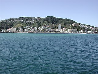
Wellington City Council is a territorial authority in New Zealand, governing the city of Wellington, the country's capital city and third-largest city by population, behind Auckland and Christchurch. It consists of the central historic town and certain additional areas within the Wellington metropolitan area, extending as far north as Linden and covering rural areas such as Mākara and Ohariu. The city adjoins Porirua in the north and Hutt City in the north-east. It is one of nine territorial authorities in the Wellington Region.

Karori is a suburb located at the western edge of the urban area of Wellington, New Zealand, 4 km from the city centre and is one of New Zealand's most populous suburbs, with a population of 15,380 in June 2023.

Johnsonville is a large suburb in northern Wellington, New Zealand. It is seven kilometres north of the city centre, at the top of the Ngauranga Gorge, on the main route to Porirua. It is commonly known by locals as "J'ville".

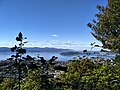
Khandallah is a suburb of Wellington, the capital city of New Zealand. It is located 4 kilometres (2.5 mi) northeast of the city centre, on hills overlooking Wellington Harbour.

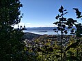
Ngaio is an inner suburb of Wellington, the capital city of New Zealand. It is situated on the slopes of Mount Kaukau, 3500 metres north of the city's CBD. It was settled in the 1840s and many of its streets are named after early settler families. Ngaio was originally a logging community known first as Upper Kaiwarra, then as Crofton until 1908. The area was administratively part of a separate local authority called the Onslow Borough Council which amalgamated with Wellington City in 1919.

Mount Hikurangi is a 1,752 m (5,748 ft) peak in the eastern corner of New Zealand's North Island, about 80 kilometres (50 mi) north of Gisborne, and 50 kilometres (31 mi) southwest of the East Cape Lighthouse. On a spur of the Raukumara Range in the Waiapu Valley, it is the North Island's highest non-volcanic peak.

Zealandia, formerly known as the Karori Wildlife Sanctuary, is a protected natural area in Wellington, New Zealand, the first urban completely fenced ecosanctuary, where the biodiversity of 225 ha of forest is being restored. The sanctuary was previously part of the water catchment area for Wellington, between Wrights Hill and the Brooklyn wind turbine on Polhill.
Freeview is New Zealand's free-to-air television platform. It is operated by a joint venture between the country's major free-to-air broadcasters – government-owned Television New Zealand and Radio New Zealand, government-subsidised Whakaata Māori, and the American-owned Warner Bros. Discovery.

The Kaiwharawhara Stream is a stream in the North Island of New Zealand – it flows through the northwestern part of New Zealand's capital, Wellington. Its headwaters lie within the suburb of Karori, and it passes through other suburbs and Otari-Wilton's Bush before reaching the western shore of Wellington Harbour in Kaiwharawhara near the terminal of the Interislander Ferry. Part of its length runs roughly alongside the Johnsonville Branch railway, a branch line that once formed part of the North Island Main Trunk Railway – the latter now passes over the stream near its mouth.

The Johnsonville Branch, also known as the Johnsonville Line, is a commuter branch line railway from the main Railway Station of Wellington, New Zealand to the northern suburb of Johnsonville via Ngaio and Khandallah.

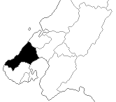
Ōhāriu, previously spelled Ohariu and then Ōhariu, is a New Zealand parliamentary electorate returning one Member of Parliament to the House of Representatives. It first existed from 1978 to 1993, and was recreated for the 2008 election. In 2008, it was the successor to Ohariu-Belmont, first contested at the first mixed-member proportional (MMP) election in 1996. Through its existence Ohariu-Belmont was represented by Peter Dunne, leader of the United Future party. Dunne contested and won the recreated electorate in 2008. He announced on 21 August 2017 that he would not stand in the 2017 general election.

Khandallah railway station is one of eight stations on the Johnsonville Line, a commuter branch railway north of Wellington in New Zealand’s North Island. The station was erected and operated by the Wellington and Manawatu Railway Company (WMR) on their line from Wellington to Longburn. From the acquisition of the WMR by the New Zealand Railways Department in 1908 until the opening of the Tawa Flat deviation in 1937, the station was on the North Island Main Trunk Railway.
Onslow was a New Zealand parliamentary electorate, from 1946 to 1963, and then from 1993 to 1996 in the Wellington area. It was represented by three Members of Parliament.

Crofton Downs is an inner suburb of Wellington, the capital city of New Zealand. It is situated between Ngaio to the northeast, Wilton to the south-west, and Wadestown to the south. Its border runs on the Korimako Stream that flows south into the Kaiwharawhara Stream and then flows down the Ngaio Gorge into Wellington Harbour.
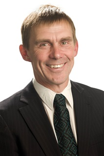
Andrew John Whitfield Foster is a New Zealand politician. He was elected to the New Zealand House of Representatives as a list MP for the New Zealand First party in the 2023 New Zealand general election.
The Old Porirua Road in the 19th century was the main road north up the west coast from Wellington to Porirua in New Zealand. It ran from Kaiwarra up the Ngaio Gorge to Ngaio, Khandallah, Johnsonville and Tawa to the Porirua Harbour. Most of the road still exists, although many sections are now local roads only, having been superseded as through roads.

Broadmeadows is a minor western suburb of Wellington, New Zealand. It is located to the north of Khandallah and south of Johnsonville. It is located 7 kilometres (4.3 mi) from the Wellington central business district. Despite its name suggesting that the area was once flat open fields, the suburb was created on steeply sloping hills and features the highest streets within Wellington City with a number of houses located more than 300m above sea level. Broadmeadows has a population of 1,635.
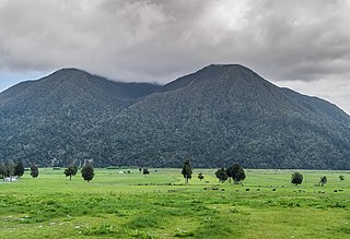
Mount Te Kinga is a mountain on the West Coast of New Zealand's South Island within the western foothills of the Southern Alps / Kā Tiritiri o te Moana. The mountain is on the south-eastern shore of Lake Brunner and is not a part of a larger mountain range, being separated from the Hohonu Range to the west by the Orangipuku River and from the Alexander Range to the southeast by the Poerua River. Numerous small creeks flow from Te Kinga, all of which end up eventually flowing into the nearby Lake Brunner.
Mount Victoria, also known as Matairangi and colloquially as Mt Vic, is a prominent 196-metre (643 ft) hill immediately to the east of central Wellington, New Zealand. About 4 kilometres due south is a spur named Mount Albert and the two are linked by a ridge. Mount Victoria gives its name to the suburb of Mount Victoria to the west.