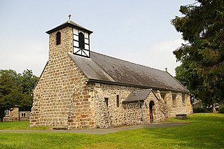
Wellpond Green

Last updated

Wellpond Green is a hamlet near the A120 road and the town of Bishop's Stortford, in the county of Hertfordshire, England. [1] Wellpond Green contains 4 listed buildings. [2]

A120 road road in England

The A120 is an important trunk road in the East of England. It follows the course of Stane Street, a Roman road from Standon, Hertfordshire at its western terminus to Colchester. From Colchester the A120 leads roughly east to the Essex port of Harwich.

Bishops Stortford town in Hertfordshire, England

Bishop's Stortford is a historic market town in Hertfordshire, England, just west of the M11 motorway on the county boundary with Essex, 27 miles (43 km) north-east of central London, and 35 miles (56 km) by rail from Liverpool Street station. Bishop's Stortford had an estimated population of 40,089 in 2017.

Hertfordshire County of England

Hertfordshire is one of the home counties in southern England. It is bordered by Bedfordshire and Cambridgeshire to the north, Essex to the east, Greater London to the south, and Buckinghamshire to the west. For government statistical purposes, it is placed in the East of England region.

At the 2011 Census the population of the hamlet was included in the civil parish of Standon. [3]

Civil parish Territorial designation and lowest tier of local government in England

In England, a civil parish is a type of administrative parish used for local government, they are a territorial designation which is the lowest tier of local government below districts and counties, or their combined form, the unitary authority. Civil parishes can trace their origin to the ancient system of ecclesiastical parishes which historically played a role in both civil and ecclesiastical administration; civil and religious parishes were formally split into two types in the 19th century and are now entirely separate. The unit was devised and rolled out across England in the 1860s.

Standon, Hertfordshire village in Hertforshire, England, United Kingdom

Standon is a village and civil parish in Hertfordshire, England. The parish includes the adjoining village of Puckeridge. The village church of St Mary has Saxon origins with much Victorian restoration. It contains the ornate tomb of the Tudor courtier Sir Ralph Sadler.

Related Research Articles

London Borough of Tower Hamlets Borough in United Kingdom

Tower Hamlets is located in East London and covers much of the traditional East End.

Cal-Nev-Ari, Nevada Census-designated place in Nevada, United States

Cal-Nev-Ari is a census-designated place on U.S. Route 95 in Clark County, Nevada, United States, near the state's southernmost point. As of the 2010 census, the town had a population of 244. The town's name is a syllabic abbreviation of California, Nevada, and Arizona.

Metropolitan Borough of Bethnal Green

Bethnal Green was a civil parish and a metropolitan borough in the East End of London, England.

Tower Hamlets College

Tower Hamlets College (THC) is a large technologically advanced further education and a constituent college of New City College in London Borough of Tower Hamlets, England. The college has four different campuses: the largest is on Poplar High Street, about 700 m north of Canary Wharf; the others are at Arbour Square, Bethnal Green and the TowerSkills on East India Dock Road. In 2017 it merged with Hackney Community College and Redbridge College to form New City College, the second largest college in London with over 20,000 students.

Llandrinio village in the county of Powys, Wales

Llandrinio is a small village and community in Montgomeryshire, Powys, Wales, close to the Wales-England border. It is situated on the B4393 road which travels from the village of Ford, Shropshire to Lake Vyrnwy.

Hawkesbury, Gloucestershire village and civil parish in South Gloucestershire, UK

Hawkesbury is a hamlet consisting of a few cottages around a triangular green. It is also the name of a civil parish in the South Gloucestershire unitary authority in England in which Hawkesbury itself lies, it is located west of Hawkesbury Upton, off the A46 road.

Hucking village in the United Kingdom

Hucking is a small hamlet and civil parish in the Maidstone District of Kent, England. It is located 4 miles (6.4 km) north-east of Maidstone and 5 miles (8.0 km) south-west of Sittingbourne. The parish is governed by a parish meeting.

Womenswold is a village and civil parish centred 7 miles (11 km) south-east of Canterbury, Kent, England, 1 mile to the east of the A2 road. The parish consists of three hamlets: Womenswold, Woolage Village and Woolage Green.

Berd Place in Tavush Province, Armenia

Berd, is a town and urban municipal community in the Tavush Province of Armenia. Formerly known as Berdagyugh, Gamma, Tavuzghala, Tauzkend, Tovuz, Volorut, Shlorut, and Ghalakyand, it is to the left of the Tavush river, 211 kilometres from Yerevan, surrounded by low mountains.

Rural Municipality of Walpole No. 92 Rural municipality in Saskatchewan, Canada

The Rural Municipality of Walpole No. 92, Saskatchewan was originally called Pipestone No. 92, Saskatchewan and is now named Walpole as of January 30, 1910. The original founding date of Pipestone was December 12, 1910

Wimborne, Alberta

Wimborne is a hamlet in southern Alberta, Canada within Kneehill County. It is located approximately 58 km (36 mi) southeast of Red Deer. It has an elevation of 975 m (3,199 ft).

White Bear, Saskatchewan Organized hamlet in Saskatchewan, Canada

White Bear is a hamlet in Lacadena Rural Municipality No. 228, Saskatchewan, Canada. Listed as a designated place by Statistics Canada, the hamlet had a population of 13 in the Canada 2006 Census. The hamlet is located approximately 55 miles (89 km) northwest of Swift Current on the north side of the South Saskatchewan River.

Wareside is a small village and civil parish in the East Hertfordshire District, in the county of Hertfordshire. The population of the civil parish as of the 2011 census is 735. It is approximately 3 miles away from the town of Ware and the larger town of Hertford, the county town of Hertfordshire. Nearby villages include Widford, Hunsdon, Babbs Green and Bakers End. Nearby hamlets include Cold Christmas and Helham Green. The B1004 linking Ware to Bishop's Stortford goes through the village and the main A10 road can be picked up at Thundridge. Fanhams Hall Road also links Wareside back to Ware. Ware railway station on the Hertford East Branch Line is located two and a half miles away.

Bunuški Čifluk Village in Jablanica District, Serbia

Bunuški Čifluk is a village in the municipality of Leskovac, Serbia. According to the 2002 census, the village has a population of 505 people.

Fordham, Essex village in the United Kingdom

Fordham is a village and civil parish in the Colchester district of the English county of Essex, six miles north-west of the town of Colchester. It has a population measured at 835 in the 2011 Census. The parish includes the nearby hamlets of Fordham Heath and Hemp's Green.

Blainsburg is an unincorporated outlier community of West Brownsville, PA; by tradition a hamlet sized neighborhood with more actual housing acreage than West Brownsville proper in Washington County, Pennsylvania, United States. Named after a U.S. Senator, James G. Blaine. Blainsburg is part of the California Area School District. West Brownsville residence students attend Brownsville Area School District in Fayette County, Pennsylvania.The bedroom community is situated on the bluff above and slightly North-northwest of West Brownsville on the river bottom below. Blainsburg is located alongside but above the climb PA Route 88 makes from the W. Brownsville river flats which bends right entering a shelf where it connects with the northwest streets of Blainsburg before taking a second ascent towards California. The parent and child communities are on the inside curve of a great meander in the Monongahela River in Southwestern Pennsylvania creating a degraded cut bank turned ramp and terrace on the opposite shore where Brownsville is situated.Blainsburg is often misspelled with an "E" in it,to match the spelling of its namesake, James G. Blaine. Blainsburg as of official records was founded & is still spelled without the "E".

Hounslow Green or Onslow Green is a hamlet on the B1008 road, located in between the villages of Barnston and Ford End, in the Uttlesford district, in the county of Essex, England. Onslow Green has a Nature Reserve with a pond.

Sandon, Hertfordshire village and civil parish in North Hertfordshire, Hertfordshire, England

Sandon is a village and civil parish in the North Hertfordshire district, in the county of Hertfordshire, England. Sandon is located near the towns of Baldock and Buntingford. The parish also includes the hamlets of Green End and Roe Green, and Blagrove Common, a nature reserve. At the 2011 Census the population of the civil parish was 495. Sandon has a church called All Saints Church. Sandon has 47 listed buildings, including one of Britain’s estimated 200 medieval barns, the construction of which has been dendrochronologically dated to 1266-68.

St Barnabass, Bethnal Green Church in London , United Kingdom

St Barnabas Bethnal Green is a late 19th-century church in Bow in London, England. It is an Anglican church in the Diocese of London. The church is at the junction of Roman Road and Grove Road in the Bow West ward of London Borough of Tower Hamlets.

The Horns, Bulls Green Datchworth, East Hertfordshire, Hertfordshire, SG3

The Horns is a public house in Datchworth, Hertfordshire, England. It is situated on Bramfield Road in Bull's Green, a hamlet in the parish of Datchworth.

References

  1. A-Z Great Britain Road Atlas, 2010 edition. p. 53.
  2. Search: +Wellpond +Green | British Listed Buildings
  3. Uk Census 2011


Coordinates: 51°52′51″N0°03′10″E / 51.88083°N 0.05278°E / 51.88083; 0.05278

Geographic coordinate system Coordinate system

A geographic coordinate system is a coordinate system that enables every location on Earth to be specified by a set of numbers, letters or symbols. The coordinates are often chosen such that one of the numbers represents a vertical position and two or three of the numbers represent a horizontal position; alternatively, a geographic position may be expressed in a combined three-dimensional Cartesian vector. A common choice of coordinates is latitude, longitude and elevation. To specify a location on a plane requires a map projection.