Related Research Articles

Little London is a village situated between the North Hampshire Downs and the gravel plains of the Kennet valley, 7 miles (11 km) north of Basingstoke and 15 miles (24 km) south of Reading. It is situated within Pamber civil parish and backs on to Pamber Forest, a 500-acre (2.0 km2) SSSI and remnant of the much larger ancient Royal Forest of Pamber. It is recorded as having been established for at least 400 years.

Hawarden is a village and community in Flintshire, Wales. It is part of the Deeside conurbation on the Wales-England border and is home to Hawarden Castle. In the 2011 census the ward of the same name had a population of 1,887, whereas the community of the same name, which also includes Ewloe Mancot and Aston had a population of 13,920. The scenic wooded Hawarden Park abuts the clustered settlement in the south. Hawarden Bridge consists of distribution and industrial business premises beyond Shotton/Queensferry and the Dee. The west of the main street is called The Highway, its start marked by the crossroads with a fountain in the middle, near which are public houses, some with restaurants.
Coleshill is a market town and civil parish in the North Warwickshire district of Warwickshire, England, taking its name from the River Cole, on which it stands. It had a population of 6,900 in the 2021 Census, and is situated 10 miles (16 km) east-northeast of Birmingham, 9 miles (14 km) southeast of Sutton Coldfield, 11 miles (18 km) south of Tamworth, 13 miles (21 km) northwest of Coventry by road and 13 miles (21km) west of Nuneaton. It is also home to a 502 year old school, being The Coleshill School seated next to the dual carriageway.
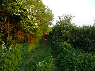
A drovers' road, drove road, droveway, or simply a drove, is a route for droving livestock on foot from one place to another, such as to market or between summer and winter pasture. Many drovers' roads were ancient routes of unknown age; others are known to date back to medieval or more recent times.

Abergwyngregyn is a village and community of historical note in Gwynedd, a county and principal area in Wales. Under its historic name of Aber Garth Celyn it was the seat of Llywelyn ap Gruffudd. It lies in the historic county of Caernarfonshire.
Dinas is a large hamlet near Bontnewydd, Caernarfon, in Gwynedd, north-west Wales.

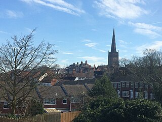
Cubbington is a village and civil parish with a population of 3,929, adjoining the north-eastern outskirts of Leamington Spa, Warwickshire, England, approximately 3 miles from the town centre. Welsh Road, running through the village crossroads, was an old sheep drovers' route connecting London and Wales. Since the 1950s when the village expanded there have been two parts to the village: Cubbington proper which was the old village core, and New Cubbington which is to the west, although both are referred to as Cubbington. Topographically the highest point of the village sits about 100 metres (330 ft) above sea level while its lowest is about 60 metres (200 ft). For many years the electorate for Cubbington was represented in government by the MP for Warwick and Leamington but for the 2010 UK Elections it moved to the new Kenilworth & Southam constituency.
Little London is a hamlet consisting of approximately 70 houses located immediately east of the village of Oakley in Buckinghamshire and about 5.5 miles (9 km) northwest of the market town of Thame in neighbouring Oxfordshire.

Llanarmon-yn-Iâl is a village, and local government community, in Denbighshire, Wales, lying in limestone country in the valley of the River Alyn.

The A452 is a road in England, which runs from Royal Leamington Spa, Warwickshire to Brownhills in the West Midlands. It is the major link to the M6 motorway for both Leamington and Warwick in addition to serving as Leamington's link to the M40 motorway and to Coventry.

Caerhun is a scattered rural community, and former civil parish, on the west bank of the River Conwy. It lies to the south of Henryd and the north of Dolgarrog, in Conwy County Borough, Wales, and includes several small villages and hamlets including Llanbedr-y-cennin, Rowen, Tal-y-bont and Ty'n-y-groes. It was formerly in the historic county of Caernarvonshire. At the 2001 census, it had a population of 1,200, increasing to 1,292 at the 2011 census. It includes a large part of the Carneddau range including the lakes of Llyn Eigiau, Llyn Dulyn and Llyn Melynllyn.

Bwlch-y-Ddeufaen is a mountain pass in Conwy county borough, north Wales, traversable only on foot or horseback, following the former Roman road from Caerhun (Canovium) to Caernarfon (Segontium). The route may be followed by road to Rowen or to Llanbedr-y-Cennin and from either, the way, through a mountain gate, is a clearly marked green path to Abergwyngregyn. The route lies between the peaks of Tal y Fan and Drum, in the Carneddau range in north Snowdonia. The distance from Rowen to Abergwyngregyn is about nine miles of mostly high mountain footpath. Near the Abergwyngregyn end, the route forms part of the North Wales Path.

Llandegla or Llandegla-yn-Iâl is a village and community in the county of Denbighshire in Wales. In the 2011 census, the community had a population of 567.
Toll roads in Great Britain, used to raise fees for the management of roads in the United Kingdom, were common in the era of the turnpike trusts. Currently there is a single major road, the M6 Toll and a small number of bridges and tunnels where tolls are collected. In addition, there are also two UK road pricing schemes, the London congestion charge and the Durham congestion charge.

Priors Hardwick is a village and civil parish in the Stratford district of Warwickshire, England. The population of the civil parish as taken at the 2011 census was 172. The name derives from the fact that it was originally a manor belonging to the Priors of Coventry.

The New Road was a toll road built across fields around the northern boundaries of London, the first part of which opened in 1756. The route comprises the modern-day A501.

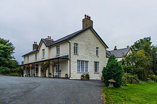
The Rhydspence Inn is a 14th-century inn situated on the Wales-England border and within the Wye Valley overlooking the Welsh hills and Herefordshire countryside. According to English Heritage it was built in the 16th century with 19th and late 20th century additions. It is a former gentry house and was not built as an inn. Until well into the sixteenth century droving on any scale in the Marches was far too risky. In such a lonely and lawless area, cattle rustling was rife, often by the authorities themselves. The Land of Speis means simply land of thorn bushes, which it is. The name is still in use today. Abbey Cwm Hir was always a modest house, the monks were predominately Welsh and apart from the Abbey's officers would have little occasion to leave it.

Blaenffos is a small village of around 200 inhabitants in the north of Pembrokeshire, Wales, in the community of Boncath. It sits on the boundary between the former parishes of Llanfihangel Penbedw and Castellan Chapelry.
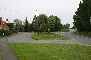
Stonebridge is a flyover–and–roundabout junction of the A45 and A452 roads in West Midlands, England. The A45 crosses the River Blythe at this point. Stonebridge lies on the former Welsh Road, a drover's road connecting North Wales to South East England; parts of the A452 roughly follow the Welsh Road. The A45 is the primary east–west connecting road between Coventry and Birmingham. It seems possible that Stonebridge, as the crossing-point of two historic major roads, was formerly an inhabited place, of which little or no trace now remains. The former Stonebridge Railway ran via Stonebridge, though there was apparently no station there. Stonebridge road junction was planned to be modernised in the first half of 2016, at a cost of £500,000. Stonebridge Highway is the official name for a section of the A45 where it nowadays bypasses Coventry to the south.
The last turnpike road between Chester and Wrexham in the United Kingdom was built in 1752 and follows the same route as the A483 road leaving Chester and thereafter the B5445 towards Wrexham.
References
- 1 2 Duignan 1912 , p. 122
- ↑ Colyer 1974
- ↑ Elrington 1957
- ↑ Drew 1967 , pp. 25–42
- ↑ "Welsh Road (A550) and Dehon House Lodge (C) Sue Adair :: Geograph Britain and Ireland". Geograph.org.uk. Retrieved 16 September 2016.