
The Cotswolds is a region in central-southwest England, along a range of rolling hills that rise from the meadows of the upper Thames to an escarpment above the Severn Valley and Evesham Vale.

Gloucestershire is a county in South West England. The county comprises part of the Cotswold Hills, part of the flat fertile valley of the River Severn and the entire Forest of Dean.

The Battle of Deorham is claimed as a decisive military encounter between the West Saxons and the Britons of the West Country in 577. The battle, which was a major victory for Wessex's forces led by Ceawlin and his son, Cuthwine, resulted in the capture of the Brythonic cities of Glevum (Gloucester), Corinium Dobunnorum (Cirencester), and Aquae Sulis (Bath). It also led to the permanent cultural and ethnic separation of Dumnonia from Wales.

Cirencester is a market town in Gloucestershire, England, 80 miles (130 km) west of London. Cirencester lies on the River Churn, a tributary of the River Thames, and is the largest town in the Cotswolds. It is the home of the Royal Agricultural University, the oldest agricultural college in the English-speaking world, founded in 1840. The town had a population of 20,229 in 2021.

The Fosse Way was a Roman road built in Britain during the first and second centuries AD that linked Isca Dumnoniorum (Exeter) in the southwest and Lindum Colonia (Lincoln) to the northeast, via Lindinis (Ilchester), Aquae Sulis (Bath), Corinium (Cirencester), and Ratae Corieltauvorum (Leicester).

Lechlade is a town at the southern edge of the Cotswolds in Gloucestershire, England, 55 miles (89 km) south of Birmingham and 68 miles (109 km) west of London. It is the highest point at which the River Thames is navigable, although there is a right of navigation that continues south-west into Cricklade, in the neighbouring county of Wiltshire. The town is named after the River Leach that joins the Thames near the Trout Inn and St. John's Bridge.
Fairford is a small market town in Gloucestershire, England. The town lies in the Cotswold hills on the River Coln, 6 miles (9.7 km) east of Cirencester, 4 miles (6.4 km) west of Lechlade and 9 miles (14 km) north of Swindon. Nearby are RAF Fairford and the Cotswold Water Park.

The region now known as Gloucestershire was originally inhabited by Brythonic peoples in the Iron Age and Roman periods. After the Romans left Britain in the early 5th century, the Brythons re-established control but the territorial divisions for the post-Roman period are uncertain. The city of Caerloyw was one centre and Cirencester may have continued as a tribal centre as well. The only reliably attested kingdom is the minor south-east Wales kingdom of Ergyng, which may have included a portion of the area. In the final quarter of the 6th century, the Saxons of Wessex began to establish control over the area.

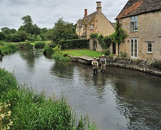
The River Leach is a river tributary to the River Thames, in England which runs mostly in Gloucestershire. It is approximately 18 miles (29 km) long, springing from the limestone uplands of the Cotswolds. In parts of its course it becomes a seasonal bourn, only running above ground when there is sufficient rainfall. Despite its small size it gives its name to two towns and a pair of villages.

The A417 is a main road in England running from Streatley, Berkshire to Hope under Dinmore, Herefordshire. It is best known for its section between Cirencester and Gloucester where it has primary status and forms part of the link between the major settlements of Swindon and Gloucester.

Northleach is a market town and former civil parish, now in parish Northleach with Eastington, in the Cotswold district, in Gloucestershire, England. The town is in the valley of the River Leach in the Cotswolds, about 10 miles (16 km) northeast of Cirencester and 11 miles (18 km) east-southeast of Cheltenham. The 2011 Census recorded the parish's population as 1,854, the same as Northleach built-up-area.

Quenington is a nucleated village and larger rural civil parish in the Cotswold district of Gloucestershire, England, on the River Coln 8 miles (13 km) east of Cirencester and 2 miles (3.2 km) north of Fairford. It has a recorded population of 603 people as at the 2011 census.
Cirencester Abbey or St Mary's Abbey, Cirencester in Gloucestershire was founded as an Augustinian monastery in 1117 on the site of an earlier church, the oldest-known Saxon church in England, which had itself been built on the site of a Roman structure. The church was greatly enlarged in the 14th century with addition of an ambulatory to the east end. The abbot became mitred 1416. The monastery was suppressed in 1539 and presented to Roger Bassinge.

Fairford railway station served the town of Fairford in Gloucestershire. It was the western terminus of the Oxford, Witney and Fairford Railway between Oxford and Fairford. It had one platform, and a stone-built station building.

Ready Token is a hamlet in Gloucestershire, England, located in the Cotswold Hills near Poulton. Despite comprising only a handful of houses it is located at a high point and is notable for being the meeting place of six country roads and nine parish boundaries. It lies at the intersection of the ancient drove road known as the Welsh Way and the Roman Akeman Street. It once possessed an inn, recorded in 1738 as under the sign Ready Token Ash.
John Tame of Cirencester and of Beauchamp Court in the parish of Fairford, both in Gloucestershire, England, was a wealthy wool producer and merchant who re-built the surviving St. Mary's Church, Fairford, the former structure of which had been built by one of the Beauchamp Earls of Warwick in the 15th century. The 28 Fairford stained glass windows he installed in the church are considered amongst the finest and most complete in England. He and his son Sir Edmund Tame (d.1534) so fostered the trade transacted at Fairford, that it came to rival that of the nearby long-established town of Cirencester, which increase was remarked upon by his contemporary the antiquary John Leland (d.1552): "Fairford never flourished afore the cumming of the Tames into it".
John Twynyho of Cirencester, Bristol and Lechlade, all in Gloucestershire, was a lawyer and wealthy wool merchant who served as Recorder of Bristol, as a Member of Parliament for Bristol in Gloucestershire in 1472-5 and in 1484 and for the prestigious county seat Gloucestershire in 1476. In 1478 he was Attorney General to Lord Edward, eldest son and heir of King Edward IV.

This is a bibliography of the City of Gloucester in the south-west of England. The city lies close to the Welsh border, on the River Severn, between the Cotswolds to the east and the Forest of Dean to the southwest. It was founded by the Romans under Emperor Nerva as Colonia Glevum Nervensis, and was granted its first charter in 1155 by King Henry II.
