
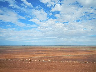
Weramo County Queensland is a cadastral division of Warrego Land District of western Queensland aa locality and a County of Queensland, Australia. [1] Weramo County is in the arid centre of the continent.
Weramo County Queensland is a cadastral division of Warrego Land District of western Queensland aa locality and a County of Queensland, Australia. [1] Weramo County is in the arid centre of the continent.
The county dates from the 8th March 1901, when the Governor of Queensland issued a proclamation legally dividing all of Queensland into counties under the Land Act 1897. [2]
Like all counties in Queensland, it is a non-functional administrative unit, that is used mainly for the purpose of registering land titles. From 30 November 2015, the government no longer referenced counties and parishes in land information systems however the Museum of Lands, Mapping and Surveying retains a record for historical purposes. [3]
The entire County is incorporated lands.
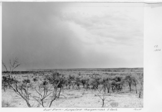
The county has a hot desert climate (BWh in the Köppen climate classification) with an average of only 22 days of rain a year. Summers are extremely hot and dry, with winters being mild to warm. The median annual rainfall for the area is 133 mm (5.2 in) [4] The actual amount of rain which falls is highly variable, for example, in 1914 just 14 mm (0.55 in) was recorded while 659 mm (25.9 in) fell in 1917. Dust storms are most likely during periods of strong wind which typically occur in spring. [4] Birdsville has recorded the highest confirmed temperature in the state of Queensland, with 49.5 °C (121.1 °F) having been recorded on more than one occasion.
Burrandilla County is a cadastral division of Queensland and a County of the Warrego Land District of south western Queensland. The county is divided into civil parishes.
Palmer County is a cadastral division of Queensland and a County of the Warrego Land District of southwestern Queensland.

Nickavilla County is a cadastral division of Queensland and a County of the Warrego Land District of southwestern Queensland.
Grey County is a cadastral division of Queensland and a County of the South Gregory District of remote western Queensland. The county is divided into civil parishes.
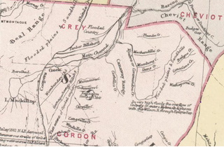
Gordon County is a cadastral division of Queensland, Australia and a County of the South Gregory District of remote western Queensland. The county is divided into civil parishes.
Cameron County, Queensland is a County of Queensland in Australia, in the South Gregory District Land District.
Wyara County, Queensland is a cadastral division of Queensland and a County of remote western Queensland.
Gowan County, Queensland is a cadastral division of Queensland and a County of the Warrego Land District of southwestern Queensland in Australia.

Paroo County, Queensland is a cadastral division of Queensland and a County of the Warrego Land District of southwestern Queensland.

Portland County, Queensland is a cadastral division of Warrego Land District of Southern Queensland and a County of Queensland, Australia.
Daroo County, Queensland is a cadastral division of Warrego Land District of Southern Queensland and a County of Queensland, Australia.

Durrie County Queensland is a cadastral division of Warrego Land District of Southern Queensland and a County of Queensland, Australia. The county is divided into civil parishes.
Werenga County Queensland is a cadastral division of Warrego Land District of Southern Queensland and a County of Queensland, Australia.

County of Carnarvon is one of the 318 counties of Queensland, Australia. It is within the Darling Downs region west Brisbane.

County of Kungie is one of the 318 counties of Queensland, Australia. The county is divided into civil parishes. It is within the Darling Downs region west Brisbane.

Rodney County is one of the 318 counties of Queensland, Australia. The county is divided into civil parishes.
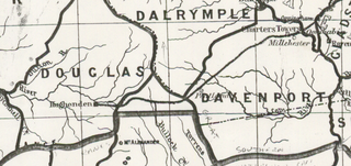
Dalrymple County, Queensland is one of the 318 counties of Queensland, Australia. The county came into existence in the 19th century, and on 8 March 1901, the Governor of Queensland issued a proclamation legally dividing Queensland into counties under the Land Act 1897. Like all counties in Queensland, it is a non-functional administrative unit, that is used mainly for the purpose of registering land titles. From 30 November 2015, the government no longer referenced counties and parishes in land information systems however the Museum of Lands, Mapping and Surveying retains a record for historical purposes.
Douglas County, Queensland is one of the 318 counties of Queensland, Australia. The county is divided into civil parishes. The county came into existence in the 19th century, and on 8 March 1901, the Governor of Queensland issued a proclamation legally dividing Queensland into counties under the Land Act 1897. Like all counties in Queensland, it is a non-functional administrative unit, that is used mainly for the purpose of registering land titles. From 30 November 2015, the government no longer referenced counties and parishes in land information systems however the Museum of Lands, Mapping and Surveying retains a record for historical purposes.
Eurinye County, Queensland is one of the 318 counties of Queensland, Australia. It is within the North Gregory District. The county came into existence in the 19th century, and on 8 March 1901, the Governor of Queensland issued a proclamation legally dividing Queensland into counties under the Land Act 1897.
Yappar County, Queensland is a cadastral division of Burke District of northern Queensland and a County of Queensland, Australia.