This article has an unclear citation style .(May 2024) |
West End Bathing Place was an outdoor swimming venue in Ipswich, Suffolk.
This article has an unclear citation style .(May 2024) |
West End Bathing Place was an outdoor swimming venue in Ipswich, Suffolk.
A bathing area for the West End of Ipswich was discussed as early as 1888 and was finally constructed in 1893 by the Ipswich Corporation. [1] The lagoon was excavated from the land beside the River Gipping and had a concrete bottom. The depth of the pool was between 3 and 10 feet. [2]
The bathing place was open from 08:00 to sunset on weekdays and 06:00 to 10:00 on Sundays. Wednesdays from 08:00 to sunset and Fridays from 08:00 to 13:00 were reserved for ladies-only swimming. [2]
Maps show the bathing place as early as 1902, located where the freshwater of River Gipping meets the brackish River Orwell, close to the southern end of the now Sir Alf Ramsey Way. [3] The bathing place was at a natural part of the river that filled at high tide to provide ideal shallow swimming. [4]
The Ipswich Swimming Club are known to have practiced there in 1913, where they held their West End Bathing Place plunging competition. [5]
In the Ipswich in 1912: King Edward Memorial Sanatorium souvenir book, from the East Anglian Daily Times , is a photo of the bathing place, complete with changing rooms along one side. [6]
Maps from 1930 continue to show the lagoon, and archive images from Britain from Above show the lagoon in 1933. [7] [8] [9] [10]
On 6 Aug 1898, there was a report of a mysterious drowning in the bathing place. The last person to see John Baxter before he drowned was Arthur Barker Welham. Welham had asked him if he had anything in hand (meaning employment) and deceased replied, "No, the world is using me very rough. I have only misery to live for, and I shall not stand it any longer than tonight." [11]
In 1912, the Ipswich Evening Star reported that Walter Edward James Hood, aged 12, attempted to save the life of 20-year-old Leonard Knights, who had disappeared beneath the surface at the West End Bathing Place while swimming. Unfortunately, Knights died. Hood was awarded a purse of money for his efforts. [12]
West End Bathing Place was closed in 1936 due to pollution from the river. [3] It is now the location of an MG car showroom.

Suffolk is a ceremonial county in the East of England and East Anglia. It is bordered by Norfolk to the north, the North Sea to the east, Essex to the south, and Cambridgeshire to the west. Ipswich is the largest settlement and the county town.

East Anglia is an area in the East of England. It comprises the counties of Norfolk and Suffolk and Cambridgeshire, with Essex also included in some definitions. The name derives from the Anglo-Saxon kingdom of the East Angles, a people whose name originated in Anglia, in what is now Northern Germany.
Ipswich is a large port town and borough in the county of Suffolk, England. Ipswich is the county town of Suffolk and is the largest settlement in the county, followed by Lowestoft and Bury St Edmunds. It is situated in East Anglia. Ipswich is the second-largest population centre in East Anglia, Norwich being the largest. It is about 80 miles (130 km) northeast of London. In 2011 it had a population of 144,957. The Ipswich built-up area is the fourth-largest in the East of England region and the 42nd-largest in England and Wales. It includes the towns and villages of Kesgrave, Woodbridge, Bramford and Martlesham Heath.

Hadleigh is an ancient market town and civil parish in the Babergh district of Suffolk, England. The town is situated next to the River Brett, between the larger towns of Sudbury and Ipswich. It had a population of 8,253 at the 2011 census. The headquarters of Babergh District Council were located in the town until 2017.

Ipswich Town Football Club is a professional football club based in Ipswich, Suffolk, England. They will compete in the 2024–25 Premier League, the top tier of English football, following successive promotions from the 2022–23 EFL League One and 2023–24 EFL Championship, both as runners-up.
Mid Suffolk is a local government district in Suffolk, England. The district is primarily a rural area, containing just three towns, being Stowmarket, Needham Market and Eye. Its council was based in Needham Market until 2017 when it moved to shared offices with neighbouring Babergh District Council in Ipswich, outside either district. In 2021 it had a population of 103,417.

Babergh District is a local government district in Suffolk, England. In 2021 it had a population of 92,300. The district is primarily a rural area, containing just two towns, Sudbury and Hadleigh, which was the administrative centre until 2017 when the council moved to shared offices with neighbouring Mid Suffolk District Council in Ipswich, outside either district. The district is named after the medieval Babergh Hundred, which covered part of the area.

Needham Market is a town in the Mid Suffolk district of Suffolk, England. Nearby villages include Barking, Darmsden, Badley and Creeting St Mary. The town of Needham, Massachusetts, was named after Needham Market.

Stowmarket is a market town and civil parish in the Mid Suffolk district, in Suffolk, England, on the busy A14 trunk road between Bury St Edmunds to the west and Ipswich to the southeast. The town lies on the Great Eastern Main Line (GEML) between Diss and Needham Market, and lies on the River Gipping, which is joined by its tributary, the River Rat, to the south of the town.

Baylham is a village and civil parish, 1,349 acres size, in the Mid Suffolk district of Suffolk, England, about 7 miles (11 km) northwest of Ipswich and 6 miles (9.7 km) southeast of Stowmarket.

The East Anglian derby is a term used to describe football matches held between Norwich City and Ipswich Town, the only fully professional football clubs in the neighbouring East Anglian counties of Norfolk and Suffolk respectively. In recent years it has sometimes been humorously called the Old Farm derby, a reference to the Old Firm derby played between rival Glasgow clubs Celtic and Rangers, and to the prominence of agriculture in East Anglia. The derby has been described as one of the best derbies in the UK.

The East Anglian Daily Times is a British local newspaper for Suffolk and Essex, based in Ipswich.
Wherstead is a village and a civil parish located in the county of Suffolk, England. Wherstead village lies 3 miles (4.8 km) south of Ipswich on the Shotley peninsula. It is in the Belstead Brook electoral division of Suffolk County Council.
Ipswich Borough Council is the local authority for Ipswich, a non-metropolitan district with borough status in Suffolk, England. It is the second tier of a two-tier system, fulfilling functions such as refuse collection, housing and planning, with Suffolk County Council providing county council services such as transport, education and social services.

Stoke is the south west part of Ipswich, Suffolk, bounded by the River Orwell and Belstead Brook. To the west lie the Chantry estates. Stoke is associated with the coming of the railway and consequent industrialisation. Nowadays it is a suburb with many housing developments.
Ipswich Stadium was a greyhound racing stadium situated in Ipswich, Suffolk.

The 2021 Suffolk County Council election took place on 6 May 2021 as part of the 2021 local elections in the United Kingdom. All 75 councillors were elected from 63 electoral divisions, which return either one or two county councillors each, by first-past-the-post voting, for a four-year term of office.
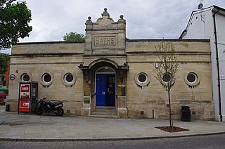
Fore Street Swimming Pool is a swimming venue in Ipswich that opened on 4 March 1894.
Stoke Bathing Place was an outdoor swimming venue in Ipswich, Suffolk.
Pipers Vale Pool was an outdoor swimming venue in Ipswich, Suffolk.