It originally had two working water mills fed by the Long Nanny stream these were fed by means of a sluices and a sluice gate the remnants of which can still be seen in the woods surrounding the stream.
The sluice gate was unusual as it had fitted a water wheel that drove a generator which in turn fed power to the nearby house it also had a shed full of batteries to act as a store, the installation was made by the local garage owner (Mr Ord) whose wife still lived there until the 1970s.
There is a quarry pond in the village that no one seems to know much about and was used at one time as a dump for rubbish and old cars and now is a popular wildlife habitat.
To the North of the village is the disused North Sunderland Railway, which ran from Chathill to Seahouses but closed in 1951. The route is marked by its cutting and bridge.
In the fields surrounding the village are signs or ancient agriculture from the standing stone to the ridged contours of the fields showing strip agriculture and the dark patches of old coal mining.
Wikimedia Commons has media related to West Fleetham.
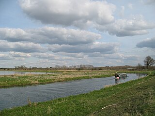
The River Witham is a river almost entirely in the county of Lincolnshire in the east of England. It rises south of Grantham close to South Witham at SK8818, passes through the centre of Grantham, passes Lincoln at SK9771 and at Boston, TF3244, flows into The Haven, a tidal arm of The Wash, near RSPB Frampton Marsh. The name "Witham" seems to be extremely old and of unknown origin. Archaeological and documentary evidence shows the importance of the Witham as a navigable river from the Iron Age onwards. From Roman times it was navigable to Lincoln, from where the Fossdyke was constructed to link it to the River Trent. The mouth of the river moved in 1014 following severe flooding, and Boston became important as a port.
The River Welland is a lowland river in the east of England, some 65 miles (105 km) long. It drains part of the Midlands eastwards to The Wash. The river rises in the Hothorpe Hills, at Sibbertoft in Northamptonshire, then flows generally northeast to Market Harborough, Stamford and Spalding, to reach The Wash near Fosdyke. It is a major waterway across the part of the Fens called South Holland, and is one of the Fenland rivers which were laid out with washlands. There are two channels between widely spaced embankments with the intention that flood waters would have space in which to spread while the tide in the estuary prevented free egress. However, after the floods of 1947, new works such as the Coronation Channel were constructed to control flooding in Spalding and the washes are no longer used solely as pasture, but may be used for arable farming.
The River Ancholme is a river in Lincolnshire, England, and a tributary of the Humber. It rises at Ancholme Head, a spring just north of the village of Ingham and immediately west of the Roman Road, Ermine Street. It flows east and then north to Bishopbridge west of Market Rasen, where it is joined by the Rase. North of there it flows through the market town of Brigg before draining into the Humber at South Ferriby. It drains a large part of northern Lincolnshire between the Trent and the North Sea.
The River Little Ouse, also known as the Brandon River, is a river in the east of England, a tributary of the River Great Ouse. For much of its length it defines the boundary between Norfolk and Suffolk.
The Derwent is a river in Yorkshire in the north of England. It flows from Fylingdales Moor in the North York Moors National Park, east then southwards as far as its confluence with the River Hertford then westwards through the Vale of Pickering, south through Kirkham Gorge and the Vale of York, joining the River Ouse at Barmby on the Marsh. The confluence is unusual in that the Derwent converges on the Ouse at a shallow angle in an upstream direction.
Seahouses is a large village on the North Northumberland coast in England. It is about 20 kilometres (12 mi) north of Alnwick, within the Northumberland Coast Area of Outstanding Natural Beauty.
The River Idle is a river in Nottinghamshire, England whose source is the confluence of the River Maun and River Meden near Markham Moor. The Idle flows north from its source through Retford and Bawtry before entering the River Trent at West Stockwith. Its main tributaries are the River Poulter and the River Ryton. The river is navigable to Bawtry, and there is a statutory right of navigation to Retford. Most of the land surrounding the river is a broad flood plain and the river is important for conservation, with Sites of Special Scientific Interest being designated along its course.
The River Nar is a river in England, a tributary of the River Great Ouse. It rises at Mileham near Litcham in Norfolk and flows 15 miles west through Castle Acre and Narborough, joining the Ouse at King's Lynn. It has had a variety of alternative names, such as the Setch, the Sandringham, and Lynn Flu, though these are rarely, if ever, used today. In 2011 the Nar was recognised by the Environment Agency as one of the top ten most improved rivers in England and Wales.
Bourne Eau is a short river which rises from an artesian spring in the town of Bourne in Lincolnshire, England, and flows in an easterly direction to join the River Glen at Tongue End. Within the town, it once powered three water mills, one of which is now a heritage centre. At Eastgate, it becomes much wider as it was navigable in the 18th and 19th centuries, and this was the location of the terminal basin. Below the town it is an embanked river, as its normal level is higher than that of the surrounding Fens. Navigation ceased in the 1860s and the river now forms an important part of the drainage system that enables the surrounding fen land to be used for agriculture.
Chathill is a hamlet and former civil parish, now in the parish of Ellingham, in Northumberland, England. It is about 9 miles (14 km) north of Alnwick and 3 miles (5 km) inland from the North Sea coast. It is served by Chathill railway station. It is on the main road serving Seahouses and the northern coast. In 1951 the parish had a population of 59.
Adlingfleet is a drained, fertile, former marshland village and former civil parish, now in the parish of Twin Rivers, in the East Riding of Yorkshire, England. It is 6.5 miles (10.5 km) east-southeast of Goole town centre. Its sea wall along the far north-east is set back from the Ouse estuary leaving the largest single reedbed in England. In 1961 the parish had a population of 137.
Barrow upon Humber is a village and civil parish in North Lincolnshire, England. The population at the 2011 census was 3,022.
Plumpton is a village and civil parish in the Lewes District of East Sussex, England. The village is located five miles (8 km) north-west of Lewes. The parish measures 6.5 miles in length on its north–south axis and 1 mile at its widest on the B2116 Underhill Road. The southern half of the parish lies within the South Downs National Park and at the highest point, 214m (702 feet), the South Downs Way traverses the crest of Plumpton Plain. The parish includes the small village of Plumpton adjacent to the Downs and to the north the larger village of Plumpton Green where most of the community and services are based. Plumpton is known for its race course, and also Plumpton College, which farms over 2500 acres of land and has become one of the leading centres for land-based education in the UK.
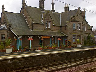
Chathill is a railway station on the East Coast Main Line, which runs between London King's Cross and Edinburgh Waverley. The station, situated 46 miles 1 chain north of Newcastle, serves the hamlet of Chathill, and surrounding coastal villages of Beadnell and Seahouses in Northumberland, England. It is owned by Network Rail and managed by Northern Trains.
The North Sunderland Railway was a railway line in Northumberland, England. It was opened in 1898, and ran from Chathill to Seahouses, with an intermediate station at North Sunderland. Chathill was on the main line of the North Eastern Railway between Morpeth and Berwick. The branch was four miles in length and a single track with standard gauge track.
Seahouses railway station was the brick and wood built eastern terminus of the single track branch of the North Sunderland Railway, in north east England. The line connected village and port of Seahouses to the railway network via a junction at Chathill.
North Sunderland railway station was a brick built station on the single track branch of the North Sunderland Railway, in north east England. The line connected the village and port of Seahouses to the railway network via a junction at Chathill.
Enchanted Pond is a mountain pond in the U.S. state of Maine. Situated in the Western Maine Mountains in the Northwest Somerset Region, the pond is located in a deep mountain valley between Coburn Mountain and Shutdown Mountain. Near its southern end, the pond is distinguished by two rockslides from the exposed cliffs of these mountains that extend down into the water along both shores. Enchanted Pond is fed by mountain springs and Little Enchanted Pond, and is the primary source of Enchanted Stream which flows into the Dead River, a tributary of the Kennebec River. Development on the pond is limited to a small set of sporting camps at the northern end of the pond and one remote camp on the southwest shore, both a part of Bulldog Camps. There are no islands in the pond.
Hedon Haven is a waterway that connected the Humber Estuary with the port of Hedon, in Holderness, East Riding of Yorkshire, England. The waterway allowed ships to unload at the port in Hedon, which was also known as Hedon Haven and had, at its peak, three canalised arms that stretched into the town. The port at Hedon was the main port for south Holderness between the 12th and 13th centuries, and was the busiest port in Holderness before the docks at Hull were built.
Swinefleet Warping Drain is an artificial waterway in the English county of the East Riding of Yorkshire, which was built to allow silt to be deposited on the peat moors, but now functions as a land drainage channel. It was constructed by Ralph Creyke, and the first section was completed in 1821.
This page is based on this Wikipedia article Text is available under the CC BY-SA 4.0 license; additional terms may apply. Images, videos and audio are available under their respective licenses.