The Kuskulana Glacier is a glacier in the Wrangell Mountains of Alaska.

Verila Glacier on Livingston Island in the South Shetland Islands, Antarctica is situated southeast of southern Etar Snowfield, southwest of Berkovitsa and Tundzha Glaciers, and west of Kamchiya Glacier. It is bounded by Rotch Dome to the west, Casanovas Peak and Snow Peak to the north, and Ustra Peak to the southeast. The glacier is roughly crescent-shaped, extending 7 nautical miles in an east-west direction and 2 nautical miles in a north-south direction, and drains southwards into Walker Bay, Bransfield Strait between John Beach and Liverpool Beach at Hannah Point. The glacier's bedrock is connected to Kaliman Island in Walker Bay by a 600 m long moraine tombolo. The area was visited by 19th century British and American sealers.
Babine Lake Marine Provincial Park is a provincial park in British Columbia, Canada. The park was established by Order-in-Council in 1993, comprising two sites at Pendleton Bay totalling 36.9 hectares. Another was established in the same year at Smithers Landing, comprising approximately 157.8 hectares. Three more sites were added in 2001, Hook (Deep) Bay, Pierre Creek, Pinkut Creek and Sandpoint. All sites combined comprise approximately 492 hectares.

The Gwa'Sala-Nakwaxda'xw Nations are a union of two Kwakwaka'wakw peoples in a band government based on northern Vancouver Island in British Columbia, Canada, whose main reserve community is near the town of Port Hardy in the Queen Charlotte Strait region of the Central Coast region of British Columbia, Canada. The band government is a member of the Kwakiutl District Council and, for treaty negotiation purposes, the Winalagalis Treaty Group which includes three other members of the Kwakiutl District Council.
Kwikwasut'inuxw Haxwa'mis, formerly the Kwicksutaineuk-ah-kwa-mish First Nation is a First Nations band government based on northern Vancouver Island in British Columbia, Canada, in the Queen Charlotte Strait region. It is a member of the Musgamagw Tsawataineuk Tribal Council, along with the ‘Namgis First Nation and the Tsawataineuk First Nation. The Kwikwasut'inuxw and Haxwa'mis are two of the many subgroups of the peoples known as Kwakwaka'wakw, which means "speakers of Kwak'wala", their language, and were combined into one band by the Department of Indian and Northern Affairs.
The Lytton First Nation, a First Nations government, has its headquarters at Lytton in the Fraser Canyon region of the Canadian province of British Columbia. While it is the largest of all Nlaka'pamux bands, unlike all other governments of the Nlaka'pamux (Thompson) people, it is not a member of any of the three Nlaka'pamux tribal councils, which are the Nicola Tribal Association, the Fraser Canyon Indian Administration and the Nlaka'pamux Nation Tribal Council.

The Ha-Iltzuk Icefield is an icefield in the central Pacific Ranges of the Coast Mountains in British Columbia, Canada. It is the largest icefield in the Coast Mountains south of the Alaska Panhandle, with an area of 3,610 km2 (1,390 sq mi). It is located on the west side of the Klinaklini River and the Waddington Range. The highest summit in the icefield is Mount Silverthrone, which is a mountain on the northeast edge of a circular, 20 km (12 mi) wide, deeply dissected caldera complex called the Silverthrone Caldera.
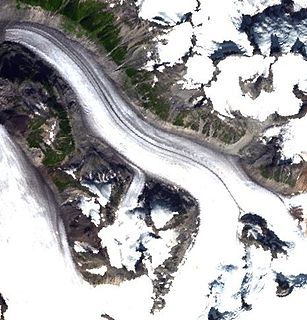
The Pashleth Glacier is a glacier south of the Machmell River and west of the Klinaklini Glacier in southwestern British Columbia, Canada.
Taylor Pass is a mountain pass in the Chilcotin Ranges of the Coast Mountains of British Columbia, Canada, located at the divide between the headwaters of the Taseko River and those of Gun Creek, a tributary of the Bridge River.
Klinaklini Canyon is a canyon on the Klinaklini River in the Pacific Ranges of the Coast Mountains in British Columbia, Canada, located to the north of the head of Knight Inlet in the river's lowermost reaches, upstream from the confluence of the West Klinaklini River.

Kleptuza Glacier is a 6 km long and 6 km wide glacier draining the east slopes of Mount Hector in the Trojan Range and the north slopes of Osterrieth Range on Anvers Island in the Palmer Archipelago, Antarctica. Situated southeast of Thamyris Glacier and west of Altimir Glacier. Flowing northwards to enter Fournier Bay east of Madzharovo Point and west of Studena Point.

Škorpil Glacier is the 12 km long and 10 km wide glacier on Pernik Peninsula, Loubet Coast on the west side of Antarctic Peninsula, situated northeast of Stefan Ice Piedmont and W of Solun Glacier. It drains the north slopes of Protector Heights, and flows northwards into Darbel Bay east of Madell Point.

Rumyana Glacier is the 6 nautical miles long and 2 nautical miles wide glacier on the east side of north-central Sentinel Range in Ellsworth Mountains, Antarctica, situated northwest of Patton Glacier and southeast of Delyo Glacier. It drains the east slopes of Mount Giovinetto and the north slopes of Evans Peak, and flows northeastwards to join Ellen Glacier northwest of Mount Jumper.
Drama Glacier is the 10 km long and 1.5 km wide glacier on the east side of southern Sentinel Range in Ellsworth Mountains, Antarctica, which is situated north of Carey Glacier and Gabare Glacier, east of the east-northeast ridge of Mount Landolt, and south of Razboyna Glacier. It is draining east-northeastwards to join Rutford Ice Stream northeast of Long Peak.
Kopsis Glacier is a 7 nautical miles long and 2 nautical miles wide glacier on the east side of north-central Sentinel Range in Ellsworth Mountains, Antarctica that is draining northeastwards from Panicheri Gap, Voysil Peak and Mount Gozur to join Embree Glacier northwest of Mirovyane Peak.
Mount Jacobsen, 3031 m, is a mountain in the northernmost Pacific Ranges of the Coast Mountains in the Central Coast region of British Columbia, Canada, located to the south of the Bella Coola Valley and immediately south of Ape Lake, to the west of the valley of the Talchako River.
Mosely Creek is a large creek in the Pacific Ranges of the Coast Mountains in British Columbia, Canada, flowing southwest to join the Homathko River in its canyon downstream from Tatlayoko Lake, and a short distance above Murderers Bar at 51°16′00″N124°54′00″W, which is the site of the opening events of the Chilcotin War of 1864.

