
West Petpeswick in Nova Scotia
West Petpeswick is a rural community of the Halifax Regional Municipality in the Canadian province of Nova Scotia. [1]
Coordinates: 44°44′32.4″N63°10′11″W / 44.742333°N 63.16972°W
West Petpeswick is a rural community of the Halifax Regional Municipality in the Canadian province of Nova Scotia. [1]
Coordinates: 44°44′32.4″N63°10′11″W / 44.742333°N 63.16972°W
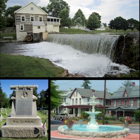
Newville is a borough in Cumberland County, Pennsylvania. The borough is located west of Carlisle. The population was 1,376 at the 2020 census. It is part of the Harrisburg–Carlisle metropolitan statistical area.
Barrackville is a town in Marion County, West Virginia, United States. The population was 1,211 at the 2020 census.

The St. Croix River is a river in northeastern North America, 71 miles (114 km) in length, that forms part of the Canada–United States border between Maine (U.S.) and New Brunswick (Canada). The river rises in the Chiputneticook Lakes and flows south and southeast, between Calais and St. Stephen. It discharges into Passamaquoddy Bay, in the Bay of Fundy.

Greenridge or Marshland is a name sometimes used to denote the western part of Eltingville, a neighborhood on Staten Island's South Shore.
Iroquois is a neighborhood on the south side of Louisville, Kentucky, United States. It is split into two parts by Beechmont. From a historical perspective, the northwestern section would be the Bryn Mawr neighborhood and the southeastern section would be the Kenwood neighborhood. The Iroquois neighborhood is roughly bounded by Hazelwood Avenue, Beechmont, Third Street, Kenwood Drive, and Iroquois Park. Located near the Louisville International Airport, residents have frequently complained of noise and challenged airport expansion. The largely residential neighborhood was developed as a suburb after World War II and into the 1950s.

Route 207 is a collector road in the Canadian province of Nova Scotia. It is located in the Halifax Regional Municipality and connects Dartmouth to Porters Lake on the Eastern Shore.

Musquodoboit Harbour is a rural community located in Nova Scotia, Canada within the Halifax Regional Municipality. The community is situated on the Eastern Shore at the mouth of the Musquodoboit River. The community lies 45 kilometres east of downtown Halifax. With a hospital, RCMP detachment, postal outlet, schools, recreational center, library, municipal office and other services, Musquodoboit Harbour is a serve centre for many of the surrounding communities.
Halifax was a provincial electoral district in Nova Scotia, Canada, that elected three, and then five members to the Nova Scotia House of Assembly. It existed from 1867 to 1933, at which point Halifax County was divided into five separate electoral districts: Halifax South, Halifax Centre, Halifax North, Halifax East and Halifax West.
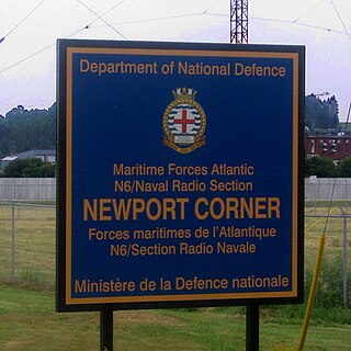
Naval Radio Section Newport Corner is a Canadian Forces naval radio station located in Brooklyn, Nova Scotia. Founded in 1942, it is still in operation today but remotely controlled from CFB Halifax.

Albion Riverside, in Battersea in London, is a high-end residential development located between Albert Bridge and Battersea Bridge on the River Thames.
Sutter Cemetery, also known South Butte Cemetery, is located in Sutter, California. One person of note buried here is Dolly Gray, who played major league baseball from 1909 to 1911.
CJTL-FM, is a Canadian radio station, that broadcasts a First Nations and Christian radio programming at 96.5 FM in Pickle Lake, Ontario, along with a radio translator CJTL-FM-1 at 98.1 FM in Thunder Bay.
Kamishak Bay is a bay on the coast of Alaska in the United States.

Grande Prairie Transit is the public transportation system in the city of Grande Prairie in northwestern Alberta, Canada. For most of its history, the bus service was operated by private contractors. During that time the Public Works Department was responsible for GP Transit and the vehicles were still owned by the city. In September 2013, the city brought the drivers in-house, allowing the city to have more flexibility in service quality and cost factors.
East Petpeswick is a rural community of the Halifax Regional Municipality in the Canadian province of Nova Scotia on the Eastern Shore.
Orle is a village in the administrative district of Gmina Wejherowo, within Wejherowo County, Pomeranian Voivodeship, in northern Poland. It lies approximately 7 kilometres (4 mi) north-west of Wejherowo and 43 km (27 mi) north-west of the regional capital Gdańsk.
Lower Montague was a municipality that held community status in Prince Edward Island, Canada. It was located to the east of Montague.
Behlmer Corner is an unincorporated community in Franklin Township, Ripley County, in the U.S. state of Indiana.
Romines Mills is an unincorporated community in Harrison County, in the U.S. state of West Virginia.
Johnson Creek is a stream in northeast Lawrence County of southwest Missouri. It is a tributary of Turnback Creek.
| | This Halifax County, Nova Scotia location article is a stub. You can help Wikipedia by expanding it. |