Related Research Articles
Little Andaman Island is the fourth largest of the Andaman Islands of India with an area of 707 km2, lying at the southern end of the archipelago. It belongs to the South Andaman administrative district, part of the Indian union territory of Andaman and Nicobar Islands. It lies 88 km (55 mi) south of Port Blair, the capital of Andaman and Nicobar Islands.

Middle Andaman Island is an island of the Andaman Islands. It belongs to the North and Middle Andaman administrative district, part of the Indian union territory of Andaman and Nicobar Islands.
Ritchie's Archipelago is a cluster of smaller islands which lie 20 km (12 mi) east of Great Andaman, the main island group of the Andaman Islands. The Islands belong to the South Andaman administrative district, part of the Indian union territory of Andaman and Nicobar Islands.
Rutland Island is an island of the Andaman Islands. It belongs to the South Andaman administrative district, part of the Indian union territory of Andaman and Nicobar Islands. The island is located 20 km (12 mi) south from Port Blair.
South Sentinel Island is one of the Andaman Islands in the Bay of Bengal. It is 1.6 km (1 mi) long northeast to southwest and up to 1 km wide. At only 1.61 km2, it is much smaller than its counterpart North Sentinel Island and is currently uninhabited. The island belongs to the Port Blair tehsil in the South Andaman administrative district, part of the Indian union territory of Andaman and Nicobar Islands, neighbouring North Sentinel Island.
Interview Island is an island of the Andaman Islands. It belongs to the North and Middle Andaman administrative district, part of the Indian union territory of Andaman and Nicobar Islands. It lies 125 km (78 mi) north of Port Blair.
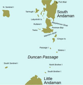
Duncan Passage is a strait in the Bay of Bengal. It is about 48 km (30 mi) wide; it separates Rutland Island to the north, and Little Andaman to the south. West of Duncan Passage is the Bay of Bengal; east is the Andaman Sea. It lies within the exclusive economic zone of India protected by the integrated tri-services Andaman and Nicobar Command of Indian Military.
Saddle Peak or Saddle Hill is located on North Andaman Island in India's Andaman and Nicobar Islands. At 732 m, it is the highest point of the archipelago in the Bay of Bengal.
North Cinque Island or Gue-a-lue is an uninhabited island of the Andaman Islands. It belongs to the South Andaman administrative district, part of the Indian union territory of Andaman and Nicobar Islands. The island is 37 km (23 mi) south of Port Blair.
South Cinque Island or Ga-o-ta-koi is an uninhabited island of the Andaman Islands. It belongs to the South Andaman administrative district, part of the Indian union territory of Andaman and Nicobar Islands. The island lies 41 km (25 mi) south from Port Blair.
Sister Islands are a group of uninhabited islands of the Andaman Islands. They belong to the South Andaman administrative district, part of the Indian union territory of Andaman and Nicobar Islands. These islands are 57 km (35 mi) south from Port Blair.
East Sister Island or Takoa-te is a small uninhabited island in the Andaman Archipelago, at the northern side of the Duncan Passage, about 6 km southeast of Passage Island and 18 km north of North Brother.
East Island is an island of the Andaman Islands. It belongs to the North and Middle Andaman administrative district, part of the Indian union territory of Andaman and Nicobar Islands. The island is located 220 km (137 mi) north from Port Blair.
West Island is an island of the Andaman Islands. It belongs to the North and Middle Andaman administrative district, part of the Indian union territory of Andaman and Nicobar Islands. The island lies 212 km (132 mi) north from Port Blair.
Cleugh Passage is a strait of the Bay of Bengal in the Andaman Islands, part of the Indian union territory of Andaman and Nicobar Islands. It lies at the north tip of North Andaman Island, and separates it from the smaller islands Landfall Island and East Island. It is about 5 km wide. West Island lies in the western approach to the passage.
Aves Island is an island of the Andaman Islands. It belongs to the North and Middle Andaman administrative district, part of the Indian union territory of Andaman and Nicobar Islands. The island lies 140 km (87 mi) north from Port Blair.
North Passage Island is an island of the Andaman Islands. It belongs to the North and Middle Andaman administrative district, part of the Indian union territory of Andaman and Nicobar Islands. The island lies 80 km (50 mi) north from Port Blair.
Passage Island or Duncan Island is an uninhabited island of the Andaman Islands. It belongs to the South Andaman administrative district, part of the Indian union territory of Andaman and Nicobar Islands. The island is 53 km (33 mi) south from Port Blair.
North and South Brother Islands are uninhabited islands in the Indian Ocean, part of the Andaman Archipelago. They belong to the South Andaman administrative district, part of the Indian union territory of Andaman and Nicobar Islands. These islands are 75 km (47 mi) south of Port Blair.
Little Andaman Group is a group of islands of the Andaman Islands, which include all islands south of Duncan Passage. It belongs to the South Andaman administrative district, part of the Indian union territory of Andaman and Nicobar Islands.
References
- ↑ US Hydrographic Office (1916) Bay of bengal Pilot, page 288. H.O. pub. 160, Government Printing Office.
- ↑ Sailing Directions (Enroute), Pub. 173: India and the Bay of Bengal (PDF). Sailing Directions . United States National Geospatial-Intelligence Agency. 2017. p. 288.
Coordinates: 11°08′33″N92°43′27″E / 11.142435°N 92.72404°E
| | This Andaman and Nicobar Islands location article is a stub. You can help Wikipedia by expanding it. |