Related Research Articles
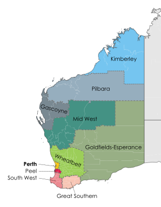
The Goldfields–Esperance region is one of the nine regions of Western Australia. It is located in the south eastern corner of Western Australia, and comprises the local government areas of Coolgardie, Dundas, Esperance, Kalgoorlie–Boulder, Laverton, Leonora, Menzies, Ngaanyatjarraku, Ravensthorpe and Wiluna.

Coolgardie–Esperance Highway is a 370-kilometre (230 mi) Western Australian highway between Coolgardie and Esperance. It runs in a north–south direction linking the state's Eastern Goldfields to the coast.

The electoral district of Pilbara is a Legislative Assembly electorate in the state of Western Australia. Pilbara is named for the region of Western Australia in which it is located. It is one of the oldest electorates in Western Australia, with its first member having been elected to the Second Parliament of the Legislative Assembly at the 1894 elections.

The Goldfields Water Supply Scheme is a pipeline and dam project that delivers potable water from Mundaring Weir in Perth to communities in Western Australia's Eastern Goldfields, particularly Coolgardie and Kalgoorlie. The project was commissioned in 1896 and completed in 1903.
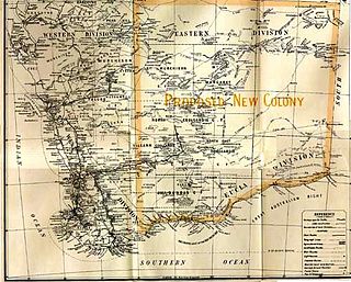
Auralia was a proposed colony that would have been formed out of the south-eastern portion of the colony of Western Australia in the early twentieth century, and would have joined the newly formed Commonwealth of Australia.

The City of Kalgoorlie–Boulder is a local government area in the Goldfields–Esperance region of Western Australia, about 550 kilometres (342 mi) east of the state capital, Perth. Covering an area of 95,575 square kilometres (36,902 sq mi), the city is the 12th largest in the world, larger than the country of Portugal with a land area of 92,212 square kilometres (35,603 sq mi). Its seat of government is the town of Kalgoorlie; all but 244 of the city's population live in either Kalgoorlie or Boulder.
Pilbara newspapers is a selection of newspapers published in the Pilbara region of Western Australia.
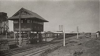
Kalgoorlie railway station is the easternmost attended station in Western Australia, located at the eastern terminus of the Eastern Goldfields Railway. It serves the city of Kalgoorlie. Beyond Kalgoorlie, the line continues east as the Trans-Australian Railway.
ABC Goldfields-Esperance is an ABC Local Radio station based in Kalgoorlie. The station broadcasts to the Goldfields-Esperance region of Western Australia, including the towns of Esperance, Coolgardie, Kambalda and Norseman.
Mining in Western Australia is administered in terms of the administrative divisions of the:-

The Division of Durack is an Australian Electoral Division in the state of Western Australia.

During the Australian gold rushes, starting in 1851, significant numbers of workers moved from elsewhere in Australia and overseas to where gold had been discovered. Gold had been found several times before, but the colonial government of New South Wales had suppressed the news out of the fear that it would reduce the workforce and destabilise the economy.
Comet Vale is an abandoned town in Western Australia located in the Goldfield region of Western Australia located between Kalgoorlie and Laverton on the Goldfields Highway. It is within the Shire of Menzies.
Mulgarrie is a ghost town, located between Kalgoorlie and Leonora in the Shire of Menzies in the Goldfields-Esperance region of Western Australia.
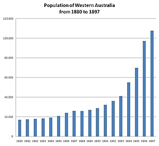
In the latter part of the nineteenth century, discoveries of gold at a number of locations in Western Australia caused large influxes of prospectors from overseas and interstate, and classic gold rushes. Significant finds included:
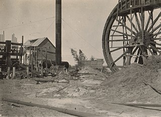
State Batteries in Western Australia were government owned and run ore-crushing facilities for the gold mining industry. Western Australia was the only Australian state to provide batteries to assist gold prospectors and small mines. They existed in almost all of the mineral fields of Western Australia.
The Coolgardie Miner was a weekly newspaper established in Coolgardie, Western Australia, at a time when Coolgardie was the prominent town in the goldfields region of Western Australia.
This is a list of newspapers published in, or for, the Goldfields-Esperance region of Western Australia.
The Chamber of Minerals and Energy of Western Australia (CME) is a peak business and employers' association in Western Australia (WA).
Main Roads Western Australia controls the major roads in the state's Goldfields-Esperance region. While the region is the state's largest, the major roads are restricted to the region's western and southern edges. From the major population centres of Kalgoorlie and Coolgardie, Great Eastern Highway heads west towards Perth via the Wheatbelt ; Coolgardie–Esperance Highway leads south to the port of Esperance via Norseman; and Goldfields Highway proceeds north to Wiluna and then on to the Mid West Region. From Norseman, Eyre Highway takes interstate traffic east across the Nullarbor Plain and into South Australia.
References
- ↑ "Ashburton Goldfield". The West Australian . Vol. 55, no. 16, 641. Western Australia. 2 November 1939. p. 8. Retrieved 10 August 2016– via National Library of Australia.
- ↑ "East Murchison Goldfield". The Daily News . Vol. XLII, no. 14, 982. Western Australia. 26 April 1923. p. 7 (Third Edition). Retrieved 10 August 2016– via National Library of Australia.
- ↑ "Gascoyne Goldfield". Western Argus . Vol. 25, no. 5054. Western Australia. 14 September 1920. p. 26. Retrieved 10 August 2016– via National Library of Australia.
- ↑ Woodward, Harry P. (1893), Report on the Murchison Goldfield, Richard Pether, Government Printer, retrieved 10 August 2016
- ↑ Compton, G. Spencer (1953), The eastern goldfields : Kalgoorlie and Boulder, G.S. Compton?, retrieved 10 August 2016
- ↑ Eastern Goldfields : a century of secondary education, 1914 - 2014, [Kalgoorlie, W.A.] [Eastern Goldfields High School?], 2014, retrieved 10 August 2016
- ↑ King, Norma (1980), Colourful tales of the Western Australian goldfields, Rigby, ISBN 978-0-7270-1127-5
- ↑ Robert Sands Frearson (1894), Western Australian goldfields, Adel, retrieved 10 August 2016
- ↑ "Western Australian Goldfields, Ltd". The Daily News . Vol. XIII, no. 6, 351. Western Australia. 19 September 1895. p. 7. Retrieved 10 August 2016– via National Library of Australia.
- ↑ Playford, Phillip E. (Phillip Elliott); Ruddock, Ian, Discovery of the Kimberley goldfield , retrieved 8 January 2024
- ↑ Riganti, A.; Johnston, J. F.; Hocking, R. M.; Martin, D. McB. (2016), Mapping Western Australia: state geological maps 1894-2015 (First ed.), Geological Survey of Western Australia, p. 6, ISBN 978-1-74168-666-1
- ↑ "Kimberley Goldfield". North Australian (Darwin) . Vol. IV, no. 11. Northern Territory, Australia. 13 August 1886. p. 3. Retrieved 8 January 2024– via National Library of Australia.
- ↑ "Kimberley Goldfield". The West Australian . Vol. XLVIII, no. 9, 306. Western Australia. 23 April 1932. p. 15. Retrieved 8 January 2024– via National Library of Australia.