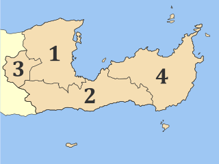
The Western Siteia Foothills are a range of foothills in Lasithi in eastern Crete, Greece. They are transitional in altitude between the Ornon Mountains, which trends from west to east starting at Kavousi in Ierapetra and ending at Praesos in the east, and the north coastal plain around and west of Sitia. Part of the Sitia Mountains, they complete the SW-NE trending massif of ridges from Ierapetra to the plain of Sitia itself.[1]
Geologically, there is little difference between the Ornon Mountains and their northern foothills, which are west of Sitia. The same ravines cut through them both, draining from the Ornon into the Sea of Crete. The Ornon, however, are nearly uninhabitable for villages, due to their altitudes and steep slopes.
On the northern side, there are no hills greater than 800m (2,600ft). This is not a good line of demarcation, however, as the hills are all much lower than 800 m. The occupation line for villages is about the 400m (1,300ft) contour line. These villages are in the Western Foothills, not the Ornon range. It so happens that a line drawn along the 400 m contour is parallel to the slightly lower Route E75.
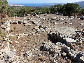
Archaeologists of the early 20th century discovered that the foothills up to the occupation line had been heavily settled by Minoan civilization, which makes sense, because Sitia is a good port, and the Minoans seldom settled the vulnerable coasts but moved up into the mountains valleys, with some notable exceptions, such as the town of Mochlos. Consequently, the Western Siteia Foothills have been excavated at many sites, including such villages as Lastros, Myrsini, Mouliana, Plakalona, and others. The name used by the archaeologists for the hills remains.
Geography
The foothills are entirely in the municipality of Siteia in Lasithi regional unit.
Crete is the largest and most populous of the Greek islands, the 88th largest island in the world and the fifth largest island in the Mediterranean Sea, after Sicily, Sardinia, Cyprus, and Corsica. Crete rests about 160 km (99 mi) south of the Greek mainland, and about 100 km (62 mi) southwest of Anatolia. Crete has an area of 8,450 km2 (3,260 sq mi) and a coastline of 1,046 km (650 mi). It bounds the southern border of the Aegean Sea, with the Sea of Crete to the north and the Libyan Sea to the south. Crete covers a vast distance from west to east but is narrow from north to south, spanning three longitudes but only half a latitude.
Lasithi is the easternmost regional unit on the island of Crete, to the east of Heraklion. Its capital is Agios Nikolaos, the other major towns being Ierapetra and Sitia. The mountains include the Dikti in the west and the Thrypti in the east. The Sea of Crete lies to the north and the Libyan Sea to the south.
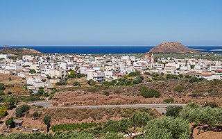
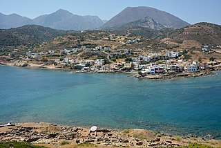
Sitia is a port town and a municipality in Lasithi, Crete, Greece. The town has 9,912 inhabitants (2011) and the municipality has 18,318 (2011). It lies east of Agios Nikolaos and northeast of Ierapetra. Sitia port is on the Sea of Crete, part of the Aegean Sea and is one of the economic centers of the Lasithi region. European route E75, which ends in Vardø, starts in Sitia. Sitia is served by the Sitia Public Airport. Sitia has not experienced the effects of mass tourism even though there is a long beach along the road leading to Vai and several places of historical interest.
Ierapetra is a Greek city and municipality located on the southeast coast of Crete.
Palaikastro or Palekastro, with the Godart and Olivier abbreviation PK, is a thriving town, geographic heir to a long line of settlements extending back into prehistoric times, at the east end of the Mediterranean island Crete. The Kallikratis Programme implemented starting 2011 made the town into a local community under jurisdiction of the next-highest levels, chained as follows: municipal unit Itanos, municipality (demos) Sitia, regional unit Lasithi, region (periphereia) Crete.
Vasiliki is the name of a village in the municipality of Ierapetra, in the prefecture of Lasithi, on Crete, and the name of the nearby Minoan archeological site. The site took its name from the village.
Achladia is the archaeological site of an ancient Minoan villa on eastern Crete.
Itanos is a municipal unit of the municipality (demos} Siteia in the Lasithi regional unit, eastern Crete, Greece. A former municipality itself, it was included in Siteia as part of the 2011 local government reform. The municipal unit has an area of 197.406 km2.
Thrypti is a mountain range in Lasithi in eastern Crete, Greece. It trends to the northeast from Ierapetra in the southwest in the direction of Sitia. However, it only goes half-way in that direction. The rest of the distance is completed by the distinct Ornon mountains, separated from the Thrypti by the Bebonas river valley, and the lower Western Siteia Foothills covering the space between the Ornon range and Sitia itself. The highest peak of Thrypti is Afentis, which is 1,476 m amsl. The three ranges constitute the West Sitia Mountains.
Makry Gialos is a former municipality in Lasithi, Crete, Greece, with a population 3,894 in 2011. It is located on the south-east coast of Crete. Since the 2011 local government reform it is part of the municipality Ierapetra, of which it is a municipal unit. The municipal unit has an area of 159.229 km2 (61.479 sq mi). The seat of the municipality was in Koutsouras, 22 kilometers east of Ierapetra. It was established in 1998 when the communities of Schinokapsala, Orino, Stavrochori, Chrisopigi, Aghios Stefanos, Pefki, Lithines and Pervolakia amalgamated into one municipality (Δήμος).
The Lasithi Plateau, sometimes spelt Lassithi Plateau, is a high endorheic plateau, located in the Lasithi regional unit in eastern Crete, Greece. Since the 1997 Kapodistrias reform, it is a municipality whose seat is Tzermiado and the second biggest village is Agios Georgios. The municipality has an area of 129,9 km2.
Karydi or Karidi, officially Καρύδιον (Σητείας), is a village in the highlands of east Crete, Greece, part of the municipal unit Itanos. Under the Kallikratis Programme of 2011 it was made a local community. Its chain of civic jurisdiction is as follows: municipal unit Itanos, municipality (demos) Sitia, regional unit Lasithi, region (periphereia) Crete. Until 2017 Karydi shared Itanos with Palaikastro, Zakros, and Mitato (Μητάτο). With the diminishment of Mitato village to no permanent residents the government abolished it in Presidential Decree No. 70/207 and turned over its settlements to Palaikastro.
Kavousi is a historic village in the municipality of Ierapetra in the prefecture of Lasithi in eastern Crete. "Kavousi" in the Cretan dialect means "water source". The village is situated 19 km (11.8 mi) northeast of Ierapetra, 26 km (16 mi) east of Agios Nikolaos and 42 km (26 mi) west of Sitia. The village is located in the northern foothills of the Thripti mountain range at an elevation of 140 meters above sea level. Many archaeological sites have been discovered in the area of Kavousi, among which are Vronda, Kastro, Azoria, Chrysokamino and the isle Pseira. Kavousi lies just 3.6 km (2.2 mi) south of Tholos Beach. The village has views over the Gulf of Mirabello and the Isthmus of Ierapetra.
The Sitia or Siteia Mountains, also known as the Sitiaka Range, are a group of four mountain ranges extending SW-NE in Lasithi in eastern Crete, Greece. Stretching from the southern coast to the plain of the city of Sitia on the northern coast, they tend to isolate east Crete from the rest of Crete, creating a refugium for the rare plant and animal species and a refuge for the ancient people practising the Minoan culture. In this ancient refuge are now to be found the ruins of Minoan sites at Mochlos, Kato Zakro, Palaikastro, and Kavousi. These are four of the major sites of East Crete, but the number of sites recorded or excavated is in the hundreds. Endemic species, many rare or endangered, are to be found in the gorges that cut from upland to ocean or valley on all sides.
Ha Gorge is a narrow gorge, at the Monasteraki Dakos, on the eastern part of the island of Crete in Greece. It is located in the west slope of Thrypti mountain range, and exits east of Vasiliki village in the plain of Ierapetra. From this location scenic views overlook Pahia Amos and the bay. Being practically inaccessible to people, the gorge maintains a rich and diverse flora and fauna. Its depth is about 1,000 metres (3,300 ft) and the fissure is said to be one of the largest in the world. Late Minoan IIIC sites are in the area.
Ornon is a mountain range in Lasithi in eastern Crete, Greece. It trends from west to east starting at Kavousi in Ierapetra and ending at Praesos in the east. Part of the Sitia Mountains, it is northeast of Thrypti and south of the Western Siteia Foothills, which border on the north coast to the west of Sitia.
The Zakros Mountains are a mountain range in Lasithi in eastern Crete, Greece. It trends to the northeast from Diaskari Beach in the southwest in the direction of Toplou Monastery near Cape Sidero.
The Coastal Hill Range, East Crete is a mountain range in Lasithi in eastern Crete, Greece. It trends to the northeast from Xerokampos in the southwest in the direction of Cape Sidero. The range, however is drowned on the eastern slopes by the Kasos Strait, a deepwater channel between the island of Kasos and the island of Crete. Its peaks thus become headlands, islands, or near-surface elevations, while the cols between them are typically beaches.
This page is based on this Wikipedia article Text is available under the CC BY-SA 4.0 license; additional terms may apply. Images, videos and audio are available under their respective licenses.