Related Research Articles

The Taupō Volcanic Zone (TVZ) is a volcanic area in the North Island of New Zealand that has been active for the past two million years and is still highly active. Mount Ruapehu marks its south-western end and the zone runs north-eastward through the Taupō and Rotorua areas and offshore into the Bay of Plenty. It is part of the larger Central Volcanic Region that extends further westward through the western Bay of Plenty to the eastern side of the Coromandel Peninsula and has been active for four million years. The Taupō Volcanic Zone is widening east–west at the rate of about 8 mm per year. It is named after Lake Taupō, the flooded caldera of the largest volcano in the zone, the Taupō Volcano.
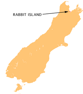
Moturoa / Rabbit Island is a small island that lies across the southernmost part of Tasman Bay / Te Tai-o-Aorere, on the northern coast of New Zealand's South Island. The long narrow island runs east–west for 8 kilometres (5 mi), and covers 15 km2 (5.8 sq mi).
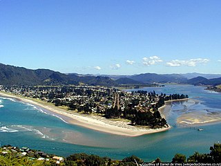
The town of Pauanui is on the east coast of the Coromandel Peninsula in the North Island of New Zealand. It lies at the mouth of the Tairua River on its south bank, directly opposite the larger town of Tairua.

The Firth of Thames is a large bay located in the north of the North Island of New Zealand. It is the firth of the rivers Waihou and Piako, the former of which was formerly named the Thames River, and the town of Thames lies on its southeastern coast.
The Thames Valley is a non-administrative region in the North Island of New Zealand. Broadly, it is the valley component of the Waihou River catchment. The lower part of the valley is more commonly known as the Hauraki Plains. Geographically the valley extends as far as the Hinuera Gap, although this is not often referred to as such. In geographical history of New Zealand, the Thames Valley was the path of the ancestral Waikato River when it discharged into the Firth of Thames over 20,000 years ago.

Turua is a small village community on the banks of the Waihou River in the Hauraki Plains in the North Island of New Zealand. It is located close to the mouth of the river, 9 kilometres south of the Firth of Thames and 12 km south of Thames. It is connected by road to SH 25 in the north and SH 2 to the south.

Mangatainoka is a small settlement in the Tararua District of New Zealand's North Island. It is located on the banks of the Mangatainoka River, 5 km (3.1 mi) north of Pahiatua.

The Warragamba River, a river that is part of the Hawkesbury-Nepean catchment, is located in the Macarthur region of New South Wales, Australia.
The Kauaeranga River is a river of New Zealand's North Island. One of the main rivers on the Coromandel Peninsula, it rises in the Coromandel Range which forms the backbone of the peninsula, flowing southwest through the Kauaeranga Valley to reach the Firth of Thames at Thames

The Mangatāwhiri River is a river of the Auckland and Waikato regions of New Zealand's North Island. It flows generally southwest from its sources in the Hunua Ranges southeast of Clevedon before flowing through a system of irrigation canals at the northern edge of the Waikato Plains close to the town of Pokeno. It reaches the Waikato River close to the township of Mercer.

The Purangi River is a river of the Coromandel Peninsula in New Zealand's North Island. It flows north to reach Mercury Bay to the east of Whitianga.

The Tuke River is a river of the West Coast Region of New Zealand's South Island. It flows northwest from the Southern Alps, combining with the Dickson River to form the Mikonui River 15 kilometres southeast of Ross.
The Waiotauru River is a river of the Wellington Region of New Zealand's North Island. It flows generally north from two branches, the Southern Waiotauru River and the Eastern Waiotauru River. Both of these branches have their origins in the southwestern Tararua Range, with the Eastern branch having its origin on the slopes of Mount Hector. The Waiotauru meets the Ōtaki River at Ōtaki Forks, 15 kilometres (9 mi) southeast of Ōtaki.
The Whangamarino River is a lowland river of the Waikato Region of New Zealand's North Island, draining the Whangamarino Wetland and associated farmland catchment. The river converges with the Waikato River just north of Meremere. The main tributary is the Maramarua River, which starts in the Hunua Ranges and forms the northern catchment of the Whangamarino River.
The Seabird Coast, also known as the Wharekawa Coast, is a beach area situated on the Firth of Thames in the North Island of New Zealand, lies about three kilometres from the small town of Miranda. It is the location of the Miranda Shorebird Centre and is well known for its godwits. On 18 November 1769, James Cook landed on the Seabird Coast as a part of the first voyage, as the HMS Endeavour circumnavigated New Zealand.

Victoria Bridge is a steel arch bridge in Hamilton, New Zealand. The bridge has a Category I heritage protection.
Cattle Creek, a partly perennial stream of the Hunter River catchment, is located in the Hunter region of New South Wales, Australia.
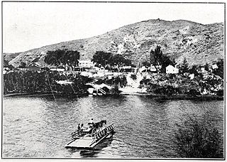
Upokongaro or Ūpokongaro is a settlement 12 kilometres (7.5 mi) upriver from Whanganui, New Zealand, in the Makirikiri Valley. Settled by Europeans in the 1860s, it was an important ferry crossing and riverboat stop. A spectacular discovery of moa bones was made in the area in the 1930s.

Mabel Wharekawa-Burt is a New Zealand Māori film and television actress and community leader.

Whakatīwai is a locality on the Seabird Coast on the western shore of the Firth of Thames, in the Hauraki District, New Zealand. Whakatīwai is the location of Wharekawa Marae, which holds importance for Ngāti Paoa and Ngāti Whanaunga. Whakatīwai Regional Park is just north of Whakatīwai. Until 2010, Whakatīwai was a part of the Franklin District. Because it was previously considered a part of the Auckland region, the Whakatīwai Regional Park continues to be owned and operated by the Auckland Council.
References
"Place name detail: Wharekawa River". New Zealand Gazetteer. New Zealand Geographic Board . Retrieved 12 July 2009.
Coordinates: 37°09′S175°52′E / 37.150°S 175.867°E