
The Taupo Volcanic Zone (TVZ) is a volcanic area in the North Island of New Zealand that has been active for the past two million years and is still highly active. Mount Ruapehu marks its south-western end and the zone runs north-eastward through the Taupo and Rotorua areas and offshore into the Bay of Plenty. It is part of the larger Central Volcanic Region that extends further westward through the western Bay of Plenty to the eastern side of the Coromandel Peninsula and has been active for four million years. The Taupo Volcanic Zone is widening east–west at the rate of about 8 mm per year. It is named after Lake Taupo, the flooded caldera of the largest volcano in the zone.

Hikuai is a small community on the Tairua River towards the base of the Coromandel Peninsula in the North Island of New Zealand. It lies 40 kilometres north of Waihi and 10 kilometres southwest of Tairua, close to the junction of State Highways 25 and 25A, the latter of which is a winding road cutting across the steep Coromandel Range of hills. It is a tourist hot spot in days such as New Zealand Labour Weekend, The Christmas Holidays and especially when Tairua and Pauanui are busy.
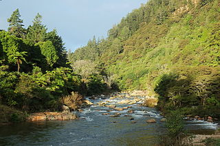
The Ohinemuri River is located in the northern half of New Zealand's North Island, at the base of the Coromandel Peninsula.

Palliser Bay is at the southern end of the North Island of New Zealand, to the southeast of Wellington. It runs for 40 kilometres along the Cook Strait coast from Turakirae Head at the southern end of the Rimutaka Ranges to Cape Palliser, the North Island's southernmost point.
The Mangahao River is located in the North Island of New Zealand. The headwaters are in the Tararua Ranges. The river flows northeast feeds into the Manawatu River south of Woodville.

Reikorangi is a rural locality on the Kapiti Coast in New Zealand's North Island. It is inland, behind Waikanae in the Akatarawa Valley of the Tararua Ranges. The Ngatiawa River and Reikorangi Stream both meet the Waikanae River in Reikorangi. Reikorangi contains a church, a monastery, and formerly contained a school, which closed in 1970 due to the declining population of the small locality.
Gladstone is a lightly populated locality in the Carterton District of New Zealand's North Island, located on the Mangahuia Stream near where the Tauweru River joins the Ruamahanga River. The nearest town is Carterton 15 kilometres to the northwest, and nearby settlements include Ponatahi to the west and Longbush to the south. It was named after British prime minister William Ewart Gladstone.
Villanueva de Jiloca is a municipality on the river Jiloca, located in the province of Zaragoza, Aragon, Spain. According to the 2012 census (INE), the municipality has a population of 60 inhabitants.
The Cape River is a river of New Zealand. A tributary of the Opouawe River, it is located in the Wairarapa in the southern North Island.
The Cobb River is a river in the Tasman Region of New Zealand. It flows southeast from Lake Cobb on the northern slopes of Mount Cobb, in Kahurangi National Park, in the northwestern South Island. The river's waters are captured behind a dam to become the Cobb Reservoir; the outflow continues to join with the Takaka River. The river is named for J.W. Cobb, a local mill owner, who discovered it.
The Little Akatarawa River is a river of the Wellington Region of New Zealand's North Island. It is a tributary of the Akatarawa River, which it meets 5 kilometres (3 mi) northwest of Te Marua.
The Mangawharariki River is a river of the Manawatu-Wanganui Region of New Zealand's North Island. It flows northwest from the Ruahine Range to meet the Rangitikei River at Mangaweka.
The Miner River is a river of the Nelson Region of New Zealand's South Island. It rises in hills 10 kilometres (6 mi) south of Nelson city centre close to the southern end of the Bryant Range, flowing west to joining with the Roding River 4 kilometres (2.5 mi) south of Richmond.
The Rangiora River is a river of the Wellington Region of the North Island of New Zealand. It is a tributary of the Waikanae River, which it joins 5 kilometres (3 mi) southeast of Waikanae.
The Sherry River is a river in New Zealand's Tasman Region. It flows north from its origins in the Hope Range to meet the Wangapeka River eight kilometres from the latter's outflow into the Motueka River.

The Waiohine River is a river of the Wellington Region of New Zealand's North Island. It flows generally south from its origins in the Tararua Range south-east of Levin, turning south-east once it reaches the plains to the north of Lake Wairarapa. From here, the river flows through many channels and irrigation features, with some of its waters reaching the lake but most flowing into the Ruamahanga River south-east of Greytown.
The Waitekauri River is a river of the Waikato Region of New Zealand's North Island. It flows south from the Coromandel Range at the foot of the Coromandel Peninsula to reach the Ohinemuri River six kilometres west of Waihi.
The Whangamarino River is a lowland river of the Waikato Region of New Zealand's North Island, draining the Whangamarino Wetland and associated farmland catchment. The river converges with the Waikato River just north of Meremere. The main tributary is the Maramarua River, which starts in the Hunua Ranges and forms the northern catchment of the Whangamarino River.
Bridgman Glacier is a steep glacier falling away from the west side of Hallett Peninsula and forming a floating ice tongue on the east shore of Edisto Inlet between Salmon Cliff and Roberts Cliff. It was named by the New Zealand Geological Survey Antarctic Expedition, 1957–58, for Lieutenant Albert H. Bridgman, MC, U.S. Navy, surgeon and U.S. Navy Operation Deepfreeze leader at Hallett Station in 1959.

Kaiwhaiki is a settlement 18 kilometres (11 mi) upriver from Whanganui, New Zealand.


