
Upper Hutt is a city in the Wellington Region of the North Island of New Zealand, and one of the four cities that constitute the Wellington metropolitan area.
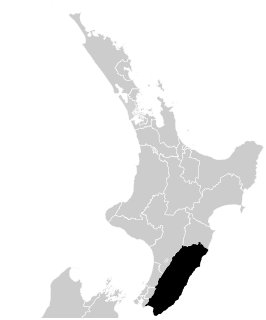
Wairarapa, is a geographical region of New Zealand. It occupies the south-eastern corner of the North Island, east of metropolitan Wellington and south-west of the Hawke's Bay region. It is lightly populated, having several rural service towns, with Masterton being the largest. It is named after its largest lake, Lake Wairarapa.

Kaitoke, part of Upper Hutt City, is a locality in the southern North Island of New Zealand. It is located at the northern end of the Hutt Valley, 45 kilometres northeast of Wellington City and six kilometres from the northern end of the Upper Hutt urban area. It also lies at the southern end of the Tararua Ranges.

The Rimutaka Incline was a 3-mile-long (4.8 km), 3 ft 6 in gauge railway line on an average grade of 1-in-15 using the Fell system between Summit and Cross Creek stations on the original Wairarapa Line in the Wairarapa district of New Zealand. The term "Rimutaka Incline" is sometimes used incorrectly to refer to other parts or all of the closed and deviated section of the Wairarapa Line between Upper Hutt and Speedy's Crossing, near Featherston. The incline formation is now part of the Remutaka Rail Trail.

Masterton is a large town in the Wellington Region of New Zealand and the seat of the Masterton District. It is the largest town in the Wairarapa, a region separated from Wellington by the Rimutaka ranges. It is 100 kilometres north-east of Wellington, 39.4 kilometres south of Eketahuna, on the Ruamahanga River.

Featherston is a town in the South Wairarapa District, in the Wellington Region of New Zealand's North Island. It is at the eastern foothills of Remutaka Range close to the northern shore of Lake Wairarapa, 63 km (39 mi) north-east of central Wellington and 37 km (23 mi) south-west of Masterton.

The Remutaka Range, is one of several mountain ranges in the North Island of New Zealand that together form a ridge running parallel with the east coast between East Cape and Wellington. The ridge is at its most pronounced in the southern part, where it consists of the Ruahine, Tararua, and Remutaka Ranges.
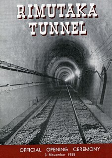
The Rimutaka Tunnel is a railway tunnel through New Zealand's Remutaka Range, between Maymorn, near Upper Hutt, and Featherston, on the Wairarapa Line.
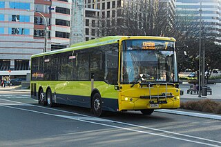
Public transport in the Wellington Region is well developed compared to other parts of New Zealand. It consists of electric and diesel buses, commuter trains, ferries and a funicular. It also included trams until 1964 and trolleybuses until 2017.
Te Marua is the northernmost urban suburb of Upper Hutt. The usual resident population in the 2006 census was 1,068. For reasons of location and distance from the city, the area is often classified as rural. Te Marua is well known for its Plateau Reserve where remnants of the old Rimutaka Railway path can be found, which now form part of a historic walk. Mt Climie, the highest peak of the Remutaka Range, can also be reached from the Reserve. The suburb is also the location of the Wellington Speedway, a nationally important venue for stock car racing.

The Orongorongo River runs for 32 kilometres (20 mi) southwest through the Orongorongo Valley in the southern Rimutaka Ranges of the North Island of New Zealand. The river and its associated catchments lie within the bounds of the Rimutaka Forest Park, which is administered by the Department of Conservation.

The Wairarapa Line is a secondary railway line in the south-east of the North Island of New Zealand. The line runs for 172 kilometres (107 mi), connects the capital city Wellington with the Palmerston North - Gisborne Line at Woodville, via Lower Hutt, Upper Hutt and Masterton.
Maymorn is a rural area of Upper Hutt city in the Wellington region of New Zealand consisting of Rural Hill and Rural Valley Floor zones. For statistical purposes, Maymorn is counted as part of Te Marua in the New Zealand census. The usual resident 2013 population of the Te Marua area was 1,152. The area is a tranquil setting consists of lifestyle blocks and farms surrounded by hills that are usually covered with a dusting of snow in the winter.

The Hutt Valley Line is the electrified train service operated by Transdev Wellington on behalf of Metlink on the section of the Wairarapa Line railway between Wellington and Upper Hutt, New Zealand.

Maymorn railway station is a twin platform, rural railway station serving the small settlement of Maymorn on the Maymorn Plateau, east of Upper Hutt, in New Zealand’s North Island. It is served by the Wairarapa Connection, and sees five services each way Monday to Thursday, six on Friday and two on Saturday and Sunday.
Cross Creek railway station was the base of operations for the Rimutaka Incline, a Fell railway over the Remutaka Ranges, and part of the original Wairarapa Line between Upper Hutt and Featherston in the Wellington region of New Zealand’s North Island. The station was between Pigeon Bush and Summit stations on the Wairarapa Line. The station was bypassed when the Rimutaka Tunnel was opened.
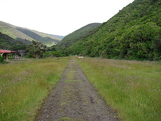
The Remutaka Rail Trail is a walking and cycling track in the North Island of New Zealand. It runs between Maymorn and Cross Creek, and follows 22 kilometres (14 mi) of the original route of the Wairarapa Line over the Remutaka Range between the Mangaroa Valley and the Wairarapa, including the world-famous Rimutaka Incline. Parts of the trail are also used by vehicles both from the regional council and from forestry companies with tree plantations in the area; members of the public have limited vehicular access from the Kaitoke end to a car park, go-kart track and gun range. Access is also granted by permission to horse riders. Touring coaches have been used upon occasion to convey tourists and other visitors to various parts of the route.
Multiple proposals have been made for a branch line railway to Wainuiomata as part of the Wellington commuter railway network. Despite strong local pressure at times during the 20th century, none of the proposals have come to fruition.

Boletopsis nothofagi is a fungus in the family Bankeraceae. The fungus forms grey fruit bodies that grow in clusters. Like all species of Boletopsis, it has a porous spore-bearing surface on the underside of the cap, but differs from other species of Boletopsis by having characteristics such as elongated spores and a green discoloration when stained with potassium hydroxide. Boletopsis nothofagi is endemic to New Zealand and has a mycorrhizal association with red beech. It is unknown when exactly the fungus forms its fruit body, but it has so far been found solely in May, during autumn in the Southern Hemisphere.

Price's Bush Tramway was around 1903 bush railway near Akatarawa in the Tararua Range of New Zealand's North Island with a raised third rail for braking the loaden trucks like on the Rimutaka Incline.


