
Wheatley Windmill is an 18th-century tower mill at grid reference SP 589 053 between the hamlet of Littleworth and Wheatley in Oxfordshire, England. [1] The windmill has an octagonal plan which narrows to form the circular rotating cap. [2]

Wheatley Windmill is an 18th-century tower mill at grid reference SP 589 053 between the hamlet of Littleworth and Wheatley in Oxfordshire, England. [1] The windmill has an octagonal plan which narrows to form the circular rotating cap. [2]
The first written evidence concerning the mill is dated 1671, describing it as being "in a ruinous condition" even then. [3] In 1760, there was significant fire and wind damage. [4] New machinery was installed in 1784, supplied by the Eagle Ironworks in Oxford. After 1914, the mill fell into disuse and disrepair. [5] However, the Wheatley Windmill Restoration Society has been restoring the windmill since 1977 [6] and it is currently open to the public.
The octagonal shape of this 18th-century tower mill is distinctly unusual; there are only two or three such towers in the UK. The tower has three storeys. There are two fireplaces on the ground floor (some mills only had one, and others none at all) and a properly framed staircase leads to the 'stone floor', i.e. the first floor, where the mill stones are set. The original curved dome cap was copper clad and has been described as being 'picturesque without being elegant'. There were originally four sails (which turned clockwise rather than the more usual anti-clock) but for a time the windmill operated on two sails only. These were of the 'common' type with a wooden frame rigged with canvas which could be set according to the state of the wind and the amount of work the miller had to do. The canvas used was similar to that used on Thames barges.

Mount Pleasant Mill is a windmill north of Kirton in Lindsey on the North Cliff Road in North Lincolnshire in the east of England.
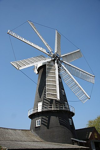
Heckington Windmill is the only eight-sailed tower windmill still standing in the United Kingdom with its sails intact.

Alford Windmill is a five-sailed windmill in Alford, Lincolnshire and the only surviving windmill out of four. Though the windmill has been restored to working order, it no longer supplies flour for sale.
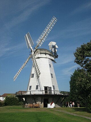
Upminster Windmill is a Grade II* listed smock mill located in Upminster in the London Borough of Havering, England. It was formerly known as Abraham's Mill and was in Essex when built. Between 2016 and 2023 the mill was restored to working order and a visitor centre was constructed. The mill and visitor centre are open to the public at selected times.
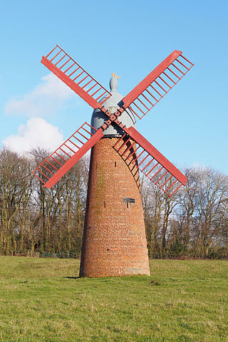
A tower mill is a type of vertical windmill consisting of a brick or stone tower, on which sits a wooden 'cap' or roof, which can rotate to bring the sails into the wind.
Wheatley is a village and civil parish in South Oxfordshire, England, about 5 miles (8 km) east of Oxford. The parish includes the hamlet of Littleworth, which is west of Wheatley.

John Webb’s or Lowe’s Mill is a Grade II* listed tower mill at Thaxted, Essex, England, which had been restored to working order, but is currently out of action following the loss of a sail in April 2010.

Bursledon Windmill is a Grade II* listed windmill in Bursledon, Hampshire, England which has been restored to working order.
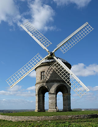
Chesterton Windmill is a 17th-century cylindric stone tower windmill with an arched base, located outside the village of Chesterton, Warwickshire. It is a Grade I listed building and a striking landmark in south-east Warwickshire.

Stembridge Tower Mill in High Ham, Somerset, England, is the last remaining thatched windmill in England. The mill is a grade II* listed building.

Great Bircham Windmill is a Grade II listed tower mill in Great Bircham, Norfolk, England.

White Mill is a smock mill west of Sandwich, Kent, England that was built in 1760. The mill has been restored and is open to the public as part of the White Mill Rural Heritage Centre. The museum also includes the miller's cottage, which has been furnished to appear as it did between 1900 and 1939. Other displays in the outbuildings include farming and craft tools, wheelwright and blacksmith workshops.

Stone Cross Windmill is a grade II* listed tower mill at Stone Cross, East Sussex, England which has been restored and is open to the public. The mill was also known as Blackness Mill and the White Mill.

Shiremark Mill, also known as Kingsfold Mill or Capel Mill was a listed Smock mill at Capel, Surrey, England, which was burnt down in 1972.

South Ockendon Windmill was a Smock mill at South Ockendon, Essex, England which collapsed on 2 November 1977.

Thelnetham Windmill, also known as Button's Mill is a Grade II* listed tower mill constructed of brick. The windmill is located at Thelnetham, Suffolk, England. It was built in the early nineteenth century to grind wheat into flour. Thelnetham windmill worked by wind power until 1924, latterly on two sails, after which it became derelict.

Holgate Windmill is a tower mill at Holgate in York, North Yorkshire, England which has been restored to working order.

Great Haseley is a village and civil parish in South Oxfordshire, England. The village is about 4.5 miles (7 km) southwest of Thame. The parish includes the hamlets of Latchford, Little Haseley and North Weston and the house, chapel and park of Rycote. The parish stretches 6 miles (10 km) along a northeast — southwest axis, bounded by the River Thame in the north, Haseley Brook in the south and partly by a boundary hedge with Little Milton parish in the west. The 2011 Census recorded a parish population of 511.
Littleworth is a hamlet in South Oxfordshire, about 4+1⁄2 miles (7 km) east of Oxford, England. It is in Wheatley civil parish, immediately west of Wheatley village.
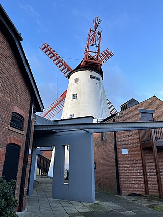
Marsh Mill is an 18th-century tower windmill in Thornton, Lancashire, England. It was built in 1794 by Ralph Slater for local landowner Bold Hesketh. It functioned as a corn mill until the 1920s and has been fully restored. It is a good example of a complete English windmill and has been designated a Grade II* listed building.
51°44′34″N1°08′56″W / 51.74274°N 1.14875°W