Related Research Articles
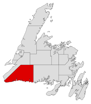
Burgeo-La Poile is a provincial electoral district for the House of Assembly of Newfoundland and Labrador, Canada. As of 2011, there are 7,527 eligible voters living within the district. The district was first created when Newfoundland joined confederation in 1949 as Burgeo and La Poile, and existed until 1975. It was recreated in 1995 following a reduction in the number of seats in the House of Assembly from 52 to 48, forming from the amalgamation of the former districts of La Poile and Burgeo-Bay D'Espoir.
Ramea is a small village in Newfoundland and Labrador located on Northwest Island, one of a group of five major islands located off the south coast of Newfoundland, Canada. The island is approximately 3.14 km long by 0.93 km wide. The other major islands in the archipelago are Great Island, Middle Island, Harbour Island, and South West Island.

Harbour Breton is a small fishing community on the Connaigre Peninsula in Fortune Bay, on the south coast of the island of Newfoundland in Canada. It is the largest center on the Connaigre Peninsula and was long considered the unofficial capital of Fortune Bay. During the 1960s many communities were resettled into Harbour Breton. Harbour Breton is the only administrative centre in Fortune Bay and is located approximately 200 kilometres (120 mi) south of Grand Falls-Windsor.

Gaultois is a small settlement in the Coast of Bays area in Newfoundland and Labrador, Canada. Gaultois had a population of 100 people as of 2021. The town has a K-12 school called Victoria Academy, as well as a fire department, public library, Lion's Club, and town hall. The town is only accessible by ferry or helicopter. The ferry runs from the nearby town of Hermitage several times daily and the crossing takes approximately 20 minutes. This ferry also services the more remote community of McCallum once to twice daily with a crossing time of around one hour and fifteen minutes. In 2015, Gaultois voted against resettlement.
Red Harbour is a Canadian municipality of Newfoundland and Labrador. It is located 20 kilometres northeast of Marystown.

Rose Blanche – Harbour le Cou is a small town on Newfoundland's southwest shore, about 45 km at the end of Route 470 from Port aux Basques. This community is located in a barren area on the east side of a small bay. In this bay there are 2 harbours that were mainly used to provide shelter for fishing vessels. Scenery includes the rugged granite coastline, and the white and rocky cliffs of "Diamond Cove". Its granite lighthouse was in operation from 1873 to the 1940s. After it was abandoned in the 1940s the building fell into ruins. The spiral stone staircase extends into the tower wall and kept the tower from collapsing while the remainder of the lighthouse fell to ruin. In 1999 the lighthouse was fully reconstructed and serves as a tourist attraction.
Hermitage-Sandyville is a small town on the south coast of Newfoundland, Canada, with a population of 404 people in the 2021 Census. The main source of income for the community is provided by the aquaculture industry, the local salmon plant and fishing.
Merasheen Island is an island in Newfoundland and Labrador, Canada. With a length of approximately 35 km and a width at its widest point of 9 km, it is situated about 6 km from Presque. It is the largest island in the Placentia Bay.
La Manche was a community on the east coast of the Avalon Peninsula of the island of Newfoundland between Cape Broyle and Tors Cove in a small inlet surrounded by steep hills. In French, la manche means "the sleeve". The area is named for the shape of the harbour, which is long and narrow with high sides. This harbour was probably first used by the French because of its seclusion which offered cover between raids on Ferryland and St. John's.
Admirals Beach is a rural community located in Newfoundland and Labrador, Canada.
Grand Bruit is a designated place and former settlement in the Canadian province of Newfoundland and Labrador. It is on the southwestern coast of the island of Newfoundland. Grand Bruit was resettled in 2010. The community was divided down the middle by a waterfall, hence the name "Grand Bruit" which is French for "great noise".
The Connaigre Peninsula is a Canadian peninsula located on the south coast of the island of Newfoundland in the province of Newfoundland and Labrador. Harbour Breton is the largest population centre on the peninsula.

Resettlement in Newfoundland and Labrador terms refers to an organized approach to centralize the population into growth areas. It is used in the current context when referring to a voluntary relocation initiated from isolated communities themselves.
The Shag Islands are a small group of islands in the southern part of Coppett Harbour, off the south coast of Newfoundland, Canada. They lie to the east of Bonalds Island. The southernmost island, Shag Island, is described as "a conspicuous white rock, 12.8m high".
Sandwich Bay, is a natural bay on the coast of Labrador in the province of Newfoundland and Labrador, Canada. The principal permanent settlement is Cartwright, located at the south entrance to the inner part of the bay. Other settlements along the bay include Paradise River and North River. Both of these communities are located at the outlets of the rivers of the same name into the bay. There is a road following the entire eastern coastline of Sandwich Bay, Newfoundland and Labrador Route 516.
Spirity Cove was a small town located at the mouth of Ingornachoix Bay on the west coast of Newfoundland and Labrador. The primary industry was fishing in the summer and logging in Hawkes Bay in the winter. The population of Spirity Cove and Kings Cove combined peaked at 96 in 1935. The community was resettled in 1966 but was still inhabited by two families until 1968. The area is still used for fishing and seasonal cabins.
Coppett was a small town located on the south coast of Newfoundland and Labrador, and north-east of Ramea. The first record of the community was in the 1857 census. Coppett grew steadily until the 1930s and at its peak had a school and two lobster factories. Several factors including the collapse of the inshore cod fishery, lack of government services and isolation caused the community to be abandoned between 1945 and 1951 without government assistance. The majority of the inhabitants resettled to Ramea or Burgeo. Several properties on the island were maintained until the 1980s for use as summer homes.
Haystack was a former fishing settlement located on the northern portion of Long Island, Placentia Bay of the island of Newfoundland in the province of Newfoundland and Labrador, Canada. People from the community freely chose to move to other places in the province during the resettlement program of the 1950s and 60s. Unlike most communities, residents were not paid to leave the community.
Long Island is a large, triangular-shaped island on the north side of Hermitage Bay, Newfoundland and Labrador, Canada.

Division No. 1, Subdivision G is an unorganized subdivision on the Avalon Peninsula in Newfoundland and Labrador, Canada. It is in Division 1 and contains the unincorporated communities of Baccalieu Island, Besom Cove, Bradley's Cove, Burnt Point, Caplin Cove, Daniel's Cove, Grates Cove, Gull Island, Job's Cove, Kingston, Long Beach, Lower Island Cove, Low Point, Northern Bay, Ochre Pit Cove, Red Head Cove, Riverhead, Smooth Cove and Western Bay.
References
- ↑ "White Bear Bay".
- ↑ United States Hydrographic Office; Davenport, Richard G. (1884). Newfoundland and Labrador: The coast and banks of Newfoundland and the coast of Labrador, from Grand Point to the Koksoak River, with the adjacent islands and banks (Public domain ed.). Govt. print. off. pp. 157–158. Retrieved 20 November 2011.
- ↑ "Resettlement - A Listing of Resettled and Abandoned Communities of the Burgeo-LaPolie District" . Retrieved 15 April 2021.
- ↑ "White Bear Bay, Newfoundland". FamilySearch .
Coordinates: 47°41′19″N57°18′50″W / 47.6886111°N 57.3138889°W
| | This Newfoundland and Labrador location article is a stub. You can help Wikipedia by expanding it. |