White City, Gloucester

Last updated

White City is an estate in the City of Gloucester. It takes its name from the original white concrete houses. [1]

Gloucester City and Non-metropolitan district in England

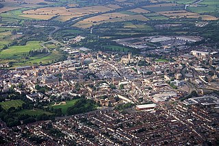
Gloucester is a city and district in Gloucestershire, in the South West of England, of which it is the county town. Gloucester lies on the River Severn, between the Cotswolds to the east and the Forest of Dean to the west, 19 miles (31 km) east of Monmouth, 17.5 miles (28.2 km) east of Wales. It has the first traditional crossing point across the longest river in the country, modernised into multiple lanes, connecting Over, a place over the water hence the name of that village — southern counties of England for many decades have been linked by three very long, lower Severn crossings in the very south-west corner of Gloucestershire, quite close to Bristol and Avonmouth on the far side of which is the River Wye being the border of South Wales for several miles.

Following World War I, there was a national movement to improve working-class housing, and rehouse families living in city centre slums. Land nearby had already been used for model housing in 1914, forming Northfield Road and Northfield Square. In 1927, Gloucester Corporation compulsorily purchased Starveall Farm to build the new homes that became White City. [2]

World War I 1914–1918 global war starting in Europe

World War I, also known as the First World War, the Great War, the Seminal Catastrophe, and initially in North America as the European War, was a global war originating in Europe that lasted from 28 July 1914 to 11 November 1918. Contemporaneously described as "the war to end all wars", it led to the mobilisation of more than 70 million military personnel, including 60 million Europeans, making it one of the largest wars in history. It is also one of the deadliest conflicts in history, with an estimated nine million combatants and seven million civilian deaths as a direct result of the war, while resulting genocides and the resulting 1918 influenza pandemic caused another 50 to 100 million deaths worldwide.

The estate was formally opened by the Duke of Gloucester, in a tree-planting ceremony held on 14 July 1928. In the 1990s, the estate was substantially rebuilt. Many of the old homes were demolished by Gloucester City Council, and new homes built by Oxbode Housing Association and Beazer Homes. [3]

Prince Henry, Duke of Gloucester Duke of Gloucester

Prince Henry, Duke of Gloucester, was the third son and fourth child of King George V and Queen Mary. He served as Governor-General of Australia from 1945 to 1947, the only member of the British royal family to hold the post.

Gloucester City Council

Gloucester City Council is the local authority for Gloucester, which is split into 18 wards, with a total of 39 councillors elected to serve on the City Council. Following the last election in 2016 there were 22 Conservative Councillors, 10 Labour Councilors, and 7 Liberal Democrat councillors. The current composition is 20 Conservative, 9 Labour, 9 Liberal Democrat, and 1 independent; the Liberal Democrats gained 1 seat from each of the Conservatives and Labour, and Conservative councillor Lee Hawthorne is currently suspended from the party.

Roads in the estate include Avening Road, Barkis Bungalows, Barnfields, Beaufort Road, Bibury Road, Broadway, Darwin Road, Dickens Close, Finlay Place, Finlay Road, Hazelton Close, Nickelby Bungalows, Northfield Road, Northfield Square, Reservoir Road, Sapperton Road, Selwyn Road and Stow Close. [4] The street names reference Gloucestershire villages as well as characters from the novels of Charles Dickens who had visited Gloucester docks in the 1850s. [5]

Charles Dickens English writer and social critic

Charles John Huffam Dickens was an English writer and social critic. He created some of the world's best-known fictional characters and is regarded by many as the greatest novelist of the Victorian era. His works enjoyed unprecedented popularity during his lifetime, and by the 20th century, critics and scholars had recognised him as a literary genius. His novels and short stories are still widely read today.

Despite its long standing, White City did not appear on any official maps of Gloucester. Residents of White City successfully campaigned for their neighbourhood to be recognised officially as a district of the City, and to appear on maps and road signs. [6] In October 2012, the present Duke of Gloucester was invited back to mark White City’s new standing. [7]

Prince Richard, Duke of Gloucester Duke of Gloucester (more)

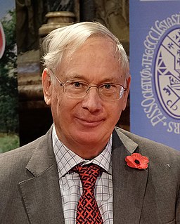
Prince Richard, Duke of Gloucester, is the youngest grandchild of King George V and Queen Mary. He practised as an architect until the death of his elder brother placed him in direct line to inherit his father's dukedom of Gloucester, which he inherited, as the second duke, in 1974. He is a paternal cousin of Queen Elizabeth II, and currently 27th in the line of succession to the British throne as well as the first in line not descended from King George VI. After the Queen he is the senior male line descendant of three British monarchs: Victoria, Edward VII and George V.

Related Research Articles

Somers Town, London area in the London Borough of Camden

Somers Town is an inner-city district in North West London. It has been strongly influenced by the three mainline north London railway termini: Euston (1838), St Pancras (1868) and King's Cross (1852), together with the Midland Railway Somers Town Goods Depot (1887) next to St Pancras, where the British Library now stands.

Northfield, Vermont Town in Vermont, United States

Northfield is a town in Washington County, Vermont, United States. The town lies in a valley within the Green Mountains and has been home to Norwich University since 1866. It contains the village of Northfield, where over half of the population lives. The town's total population was 6,207 at the 2010 census.

RAF Daws Hill

RAF Daws Hill was a Ministry of Defence site, located near High Wycombe and Flackwell Heath, in Buckinghamshire, England, close to the M40 motorway.

Hucclecote village in United Kingdom

Hucclecote is a village in Gloucestershire, United Kingdom, comprising a ward in the City of Gloucester, and an adjacent civil parish in the Borough of Tewkesbury. It is located on the periphery of the city, between Barnwood and Brockworth, along Ermin Way, an old Roman road connecting Gloucester with Cirencester and the Cotswolds.

Abbeydale and Abbeymead

Abbeydale and Abbeymead are modern suburbs of the city of Gloucester in the county of Gloucestershire, England. They lie approximately 3 miles south-east of the city centre, and are bounded by the suburbs of Coney Hill to the north west, Barnwood and Hucclecote to the north and north east, Matson to the south west and the M5 motorway to the south and east. Mostly connected with Segregated Bicycle Paths into Gloucester city along Metz Way. The village of Upton St Leonards is immediately across the M5 motorway.

Mackworth, Derby

Mackworth is a suburb and electoral ward of the city of Derby, England. Is it located on the north-west of the city near to Markeaton Park and the suburb of Mickleover. It is also known as Mackworth Estate, to distinguish it from the nearby Mackworth village. The Mackworth ward also covers the New Zealand area as well as Mackworth itself.

Whitfield is a hamlet in South Gloucestershire, England.

Innsworth human settlement in the United Kingdom

Innsworth is a suburb of Gloucester, it is a civil parish and forms part of the borough of Tewkesbury. The parish population taken at the 2011 census was 2,468.

Beaumont Road is a housing estate located in Leyton in East London. It is the largest housing estate in the borough of Waltham Forest, and is now the last high rise estate in Leyton. All neighbouring high rise estates have been demolished. It is situated just south of the Bakers Arms, on Leyton High Road.

Brompton, London suburb of London, England

Brompton is a historic area of London, formerly in the county of Middlesex. It now lies within the boundaries of the Royal Borough of Kensington and Chelsea, and notionally fans out west and southward from the City of Westminster boundary in Knightsbridge. It encompasses Brompton Square, along Kensington Gore, down Queen's Gate, and along Brompton Road, into South Kensington, then from Walton Street, into the Fulham Road up to its boundary with the London Borough of Hammersmith and Fulham, then back along the Cromwell Road/Queen's Gate through Gloucester Road along the area adjacent to Old Brompton Road. To its north lies the district of Kensington, to its south the district of Chelsea and to the west are the districts of Earl's Court and West Brompton. Its fragmented existence is commemorated chiefly through the names of streets, buildings and a cemetery.

Stoke Lodge is a suburb of Bristol, England, developed in the 1950s and early 1960s on farmland to the south of Patchway Common, South Gloucestershire and east of the A38 trunk road. Although the busy London to South Wales railway forms the south-western boundary of the estate, the sound of the trains is moderated by the railway tracks being within a cutting. The new town of Bradley Stoke lies immediately to the east, whilst the suburb of Little Stoke is on its southern edge.

Henry Bruton English businessman

Henry William Bruton was a Gloucester businessman who was a key figure in the development of the city during the later part of the nineteenth century and the early twentieth century. He was born in Newent, Gloucestershire, on 14 May 1843, the son of Henry Bruton Snr.

Westgate, Gloucester

The Westgate area of Gloucester is centred on Westgate Street, one of the four main streets of Gloucester and one of the oldest parts of the city. The population of the Westgate ward in Gloucester was 6,687 at the time of the 2011 Census.

Excalibur Estate

The Excalibur Estate is a post-war 1940s housing estate of 189 prefabricated houses in Catford, South London. The estate contains the last sizeable collection of post-war prefabricated houses in the United Kingdom. In 2011, Lewisham Council approved a plan to replace the prefabs with 371 houses, and demolition was scheduled to begin in 2013. English Heritage has granted listed building status to six of the "prefab" houses. The proposed demolition has led to campaigns from residents, English Heritage and the Twentieth Century Society to save the properties, and a legal challenge to prevent redevelopment if they are demolished and return it to parkland.

Hunts Grove is a new build suburb, situated near the villages of Hardwicke and Haresfield, on the southern edge of the city of Gloucester. Building began in 2010 and the estate is as yet unfinished. The development was named Hunts Grove after the small woodland, Hunts Grove, on the site.

Kensington New Town

Kensington New Town is an area of housing in Kensington, London, which was developed in the early 19th century. It lies to the south of Kensington High Street and to the southwest of Kensington Gardens.

Brunswick Square, Gloucester

Brunswick Square is a 1.5-acre (0.61 ha) privately owned public garden with residential streets along three of its sides, in the English city of Gloucester. It is overlooked by the Christ Church to the east on Brunswick Road. The square is surrounded by terraced houses and flats with the Gloucester National Spiritualist Church on the north side and Gloucester House on the south side. There are nine grade listed buildings around the square. The square has been part of the Eastgate and St Michaels conservation area since 1968.

The Horton Road Stadium was a football and greyhound racing stadium situated in Gloucester, England.

High Orchard

High Orchard was an industrial area of the city of Gloucester in England that was developed in the 19th century on the former orchard of the Priory of Llanthony Secunda (1136). The area was closely associated with Gloucester Docks immediately to the north, and served by the Gloucester and Sharpness Canal and railway transport. It was the site of Fielding & Platt's Atlas Works and a number of other significant local employers.

References

  1. "Old Gloucester in photographs".
  2. Jenkinson, Jerry. "White City deserves recognition". This is Gloucestershire.
  3. "Looking back at White City". This is Gloucestershire.
  4. "White City Residents Association".
  5. Bartlett, Anne. "Gloucestershire's connections with Charles Dickens".
  6. "White City to be formally recognised?". This is Gloucestershire.
  7. "Duke of Gloucester set for White City". This is Gloucestershire.

Coordinates: 51°50′42″N2°14′10″W / 51.845°N 2.236°W / 51.845; -2.236

Geographic coordinate system Coordinate system

A geographic coordinate system is a coordinate system that enables every location on Earth to be specified by a set of numbers, letters or symbols. The coordinates are often chosen such that one of the numbers represents a vertical position and two or three of the numbers represent a horizontal position; alternatively, a geographic position may be expressed in a combined three-dimensional Cartesian vector. A common choice of coordinates is latitude, longitude and elevation. To specify a location on a plane requires a map projection.