Garrett County (gərɛt) is the westernmost county of the U.S. state of Maryland. As of the 2010 census, the population was 30,097, making it the third-least populous county in Maryland. Its county seat is Oakland. The county was named for John Work Garrett (1820–1884), president of the Baltimore and Ohio Railroad. Created from Allegany County, Maryland in 1872, it was the last Maryland county to be formed.
Lake Heritage is a census-designated place (CDP) in Adams County, Pennsylvania, United States. Its population was 1,333 at the 2010 census.

Conococheague Creek, a tributary of the Potomac River, is a free-flowing stream that originates in Pennsylvania and empties into the Potomac River near Williamsport, Maryland. It is 80 miles (129 km) in length, with 57 miles (92 km) in Pennsylvania and 23 miles (37 km) in Maryland. The watershed of Conococheague Creek has an area of approximately 566 square miles (1,470 km2), out of which only 65 square miles (170 km2) are in Maryland.

Devils Den is a boulder-strewn hill on the south end of Houck's Ridge at Gettysburg Battlefield, once used by artillery and infantry on the second day of the 1863 Battle of Gettysburg during the American Civil War. A tourist attraction since the memorial association era, several boulders are worn from foot traffic and the site includes numerous cannon, memorials, and walkways, including a bridge spanning two boulders.

Seminary Ridge is a dendritic ridge which was an area of Battle of Gettysburg engagements in July 1863 during the American Civil War (1861–1865), and of military installations during World War II (1941–1945).
Back Creek is a 59.5-mile-long (95.8 km) tributary of the Potomac River that flows north from Frederick County, Virginia, to Berkeley County in West Virginia's Eastern Panhandle. Back Creek originates along Frederick County's border with Hampshire County, West Virginia, at Farmer's Gap in the Great North Mountain. Its name reflects its location to the west of North Mountain. The perspective of colonists from the east in the 18th century led them to call it "Back Creek", because it lay to the back of North Mountain.

Mill Creek is a 14.0-mile-long (22.5 km) tributary stream of the South Branch Potomac River, belonging to the Potomac River and Chesapeake Bay watersheds. The stream is located in Hampshire County in West Virginia's Eastern Panhandle. Mill Creek flows into the South Branch west of Romney Bridge near Vanderlip along the Northwestern Turnpike.
Back Creek is a 16.8-mile-long (27.0 km) tributary of Conococheague Creek in south central Pennsylvania in the United States.
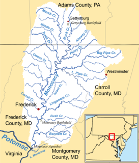
Marsh Creek is a 26.6-mile-long (42.8 km) tributary of the Monocacy River in south-central Pennsylvania and north-central Maryland in the United States.
Rock Creek is an 18.9-mile-long (30.4 km) tributary of the Monocacy River in south-central Pennsylvania and serves as the border between Cumberland and Mount Joy townships. Rock Creek was used by the Underground Railroad and flows near several Gettysburg Battlefield sites, including Culp's Hill, the Benner Hill artillery location, and Barlow Knoll.

Pennsylvania Route 134 (PA 134), also called Taneytown Road, is a north–south, two-lane state highway in Adams County, Pennsylvania. It runs from the Maryland border at the Mason–Dixon line in Mount Joy Township north to U.S. Route 15 Business in Gettysburg. PA 134 runs through farmland between the Maryland border and an interchange with the US 15 freeway. North of here, the route passes through Round Top and serves Gettysburg National Military Park before reaching its northern terminus. Taneytown Road was created in 1800 to connect Gettysburg with Taneytown, Maryland. The road was used during the 1863 Battle of Gettysburg for the procession to the cemetery consecration at which the Gettysburg Address was delivered. PA 134 was designated to its current alignment in 1928, with the section north of Round Top paved. The southern portion of the route was paved in the 1930s.

Harney is an unincorporated community in Carroll County, Maryland, USA.
Double Pipe Creek, sometimes called Pipe Creek, is a major tributary of the Monocacy River in Carroll County and Frederick County in Maryland, located several miles north and west of Westminster. The creek is only 1.6 miles (2.6 km) long, but is formed by the confluence of two much longer streams, Big Pipe Creek and Little Pipe Creek.

Barlow, Pennsylvania is a populated place between the Gettysburg Battlefield and the Mason–Dixon line at the intersection of Rock Creek and Pennsylvania Route 134. North of the creek on the road summit is the principal facility of the rural community: the 1939 community hall at the Barlow Volunteer Fire Company fire station. The hall is a Cumberland Township polling place and was used by Mamie & Dwight D. Eisenhower after purchasing their nearby farm. Horner's Mill was the site of an 1861 Union Civil War encampment, and the covered bridge was used by the II Corps and General George G. Meade en route to the 1863 Battle of Gettysburg.

Willoughby Run is a tributary of Marsh Creek in Adams County, Pennsylvania in the United States.
Winebrenner Run is a Pennsylvania stream in Gettysburg, Pennsylvania, flowing eastward to Rock Creek originally from a Gettys-Black Divide triple point near Zeigler's Grove. The Confederate military line along the stream was the starting point for the battle of East Cemetery Hill on the Battle of Gettysburg, Second Day, and most of the upstream portion of the run was engineered c. 1961 into underground drainage to open flow at the school complex near the Culp Farm at East Confederate Avenue.
Plum Run is a Pennsylvania stream and tributary of White Run which flows through East Cavalry Field of the Gettysburg National Military Park. The run forms a man-made lake above the Lake Heritage dam near the run's mouth along the Baltimore Pike.
The Nichol's Gap Road was a central Pennsylvania highway established in the 18th century near Maryland extending westward from the Black's Gap Road "just west of Little Conewago Creek" at the Crofs Keys stand of James Black. The road was past both the Rock Creek Church and 1761 Samuel Gettys tavern where Gettysburg would be surveyed in 1786. The highway was built over the South Mountain via Nichol's Gap and down the Devils Racecourse into the Cumberland Valley, allowing access to the 1762 Hagerstown, Maryland. Called the "Hagerstown Road" during the Battle of Gettysburg, parts of the road are now designated (east-to-west): U. S. Route 30 in Pennsylvania, Pennsylvania Route 116, Iron Springs Road, Gum Springs Road, and Old Route 16