Whitecross Street

Last updated

Whitecross Street Whitecross Street, London a.jpg
Whitecross Street

Whitecross Street is a short street in Islington, in Inner London. It features an eponymous street market and a large housing estate.

Contents

Since 2010, there has been an annual Whitecross Street Party one weekend in the summer, together with an exhibition of street art. [1]

Location

The immediate vicinity of Whitecross Street Whitecross Street, London.jpg
The immediate vicinity of Whitecross Street

The street is located in St Luke's, Islington. It runs north–south, between Old Street in the north, where it abuts St Luke Old Street, and the junction with Beech Street (west), Chiswell Street (east) and Silk Street (south, continuing the street) in the south. The southern junction marks the boundary with the City of London: Whitecross and Chiswell (north and east) are in Islington, while Beech and Silk (west and south) are in the city.

History

Whitecross-Street-Market plaque Whitecross-Street-Market (14698695679).jpg
Whitecross-Street-Market plaque

Whitecross Street formerly continued further south from its current southern end, to just outside Cripplegate, a gate of the London Wall surrounding the City of London.

In his 1720 work, A Survey of the Cities of London and Westminster, John Strype wrote:

In Whitecross street, King Henry V. builded one fair House; and founded there a Brotherhood of St. Giles, to be kept. Which House, had sometime been an Hospital of the French Order, by the Name of St. Giles without Cripplegate, in the Reign of Edward I. The King having the Jurisdiction, and appointing a Custos thereof, for the Precinct of St. Giles, &c. Which Hospital being suppressed, the Lands were given to the Brotherhood, for the relief of the Poor. In this Street was a White cross; and near it was built an Arch of Stone, under which ran a Course of Water down to the Moor, called now Moorfields." [2]

The Fortune Playhouse, an early Elizabethan theatre, was built on the street c.1600. John Lambe was killed in 1628 at this theatre. It was closed in 1642 as part of Parliament's closure of all theatres. A debtors' prison, Whitecross Street Prison, was built on the street in 1813–15, near Fore Street (which still exists). After the prison's closure in 1870, the Midland Railway Company built a goods terminus and a booking office for goods and passengers on the site in 1876–77.

In between 1876 and 1906 the Cripplegate Bank [3] was located at 31 and then 1 Whitecross Street, before been incorporated into the Union Bank of London. [4]

The Cripplegate area was heavily damaged during World War II. When the Barbican Estate and Barbican Centre were reconstructed after the war, the section of Whitecross Street south of Silk Street was swallowed up by the new construction. The short section between Silk Street and Chiswell Street/Beech Street became part of Silk Street. St Giles Cripplegate, mentioned by Strype, is now within the Barbican Estate.

Whitecross Street Market

Whitecross Street Market, looking northwest Whitecross Street Market.jpg
Whitecross Street Market, looking northwest

Whitecross Street Market, having been in existence for over 150 years, is one of London's oldest markets. The market was formerly one of London's great Sunday markets, and dates to the 17th century; although today, trading is largely limited to lunch times. [5] During the mid-19th century, the street vendors and costermongers operating out of an informal street market in Whitecross Street came to public attention following the publication of a series of articles written by journalist, James Greenwood, and published in the Pall Mall Gazette. Greenwood's articles presented a brutal picture of the lives of London's poorest classes and caused a public sensation. [6] By the end of the 19th century, the area had become a by-word for poverty and alcohol, and it became known as Squalors' Market. [7]

Today the market consists of stalls arranged along the northern half of the street, between Old Street and Fortune Street, with the road closed to traffic. There is a small general market and a food market of up to 50 food and drink vendors Monday–Friday lunchtime, [8] which can be bustling with activity (and queues) on a sunny lunch time. It has occasional food festivals. [9] In recent times, there has been significant investment from Islington Council, the City of London and English Heritage. It is open Monday–Friday, 10am–2pm.

Whitecross Street Prison

Whitecross Street Prison was a debtors' prison built 1813–15 to ease overcrowding at Newgate Prison. It had a capacity of 400 prisoners. It closed in 1870, when all of the prisoners were transferred to the newly built Holloway Prison. [10]

Other buildings

Whitecross Street Estate Whitecross Street Estate - geograph.org.uk - 469374.jpg
Whitecross Street Estate

The Peabody Trust, one of London's oldest and largest housing associations, has a significant estate of social housing there, the Whitecross Street Estate.

Related Research Articles

<span class="mw-page-title-main">Clerkenwell</span> Area of central London

Clerkenwell is an area of central London, England.

<span class="mw-page-title-main">Finsbury</span> District of Central London

Finsbury is a district of Central London, forming the south-eastern part of the London Borough of Islington. It borders the City of London.

<span class="mw-page-title-main">Barbican Estate</span> Residential complex in London, England

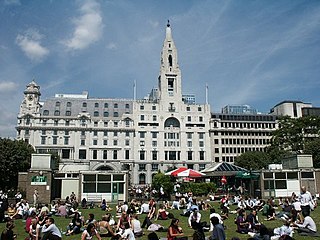
The Barbican Estate, or Barbican, is a residential complex of around 2,000 flats, maisonettes, and houses in central London, England, within the City of London. It is in an area once devastated by World War II bombings and densely populated by financial institutions, 1.4 miles north east of Charing Cross. Originally built as rental housing for middle and upper-middle-class professionals, it remains an upmarket residential estate. It contains, or is adjacent to, the Barbican Arts Centre, the Museum of London, the Guildhall School of Music and Drama, the Barbican public library, the City of London School for Girls and a YMCA, forming the Barbican Complex.

Aldersgate is a Ward of the City of London, named after one of the northern gates in the London Wall which once enclosed the City.

Cripplegate was a gate in the London Wall which once enclosed the City of London.

<span class="mw-page-title-main">Moorfields</span> Former London open space

Moorfields was an open space, partly in the City of London, lying adjacent to – and outside – its northern wall, near the eponymous Moorgate. It was known for its marshy conditions, the result of the defensive wall acting like a dam, impeding the flow of the River Walbrook and its tributaries.
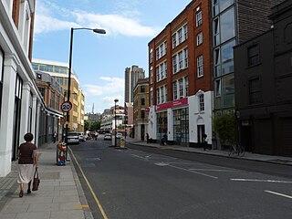
<span class="mw-page-title-main">St Giles-without-Cripplegate</span> Church in London, England

St Giles-without-Cripplegate is an Anglican church in the City of London, located on Fore Street within the modern Barbican complex. When built it stood without the city wall, near the Cripplegate. The church is dedicated to St Giles, patron saint of handicapped and infirm people of many different kinds. It is one of the few medieval churches left in the City of London, having survived the Great Fire of 1666.

<span class="mw-page-title-main">Grub Street</span> Former street in London

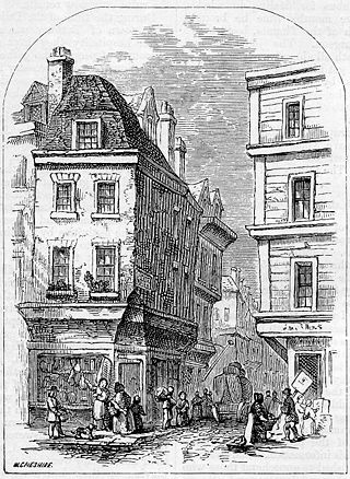
Until the early 19th century, Grub Street was a street close to London's impoverished Moorfields district that ran from Fore Street east of St Giles-without-Cripplegate north to Chiswell Street. It was pierced along its length with narrow entrances to alleys and courts, many of which retained the names of early signboards. Its bohemian society was set amidst the impoverished neighbourhood's low-rent dosshouses, brothels and coffeehouses.

<span class="mw-page-title-main">St Luke's, London</span> Human settlement in England

St Luke's is an area in central London in the Borough of Islington. It lies just north of the border with the City of London near the Barbican Estate, and the Clerkenwell and Shoreditch areas. The area takes its name from the now redundant parish church of St Luke's, on Old Street west of Old Street station. Following the closure of the church, the parish was reabsorbed into that of St Giles-without-Cripplegate, from which it had separated in 1733.

<span class="mw-page-title-main">St Luke Old Street</span> Church in London, England

St Luke's is a historic Anglican church building in central London, and in the London Borough of Islington. It served as a parish church from 1733 to 1959. It was designed by John James and Nicholas Hawksmoor, and is a Grade I listed building.

<span class="mw-page-title-main">Coleman Street Ward</span> Ward of the City of London

Coleman Street is one of the 25 ancient wards of the City of London and lies on the City's northern boundary with the London Borough of Islington.

<span class="mw-page-title-main">Caledonian Road, London</span> Road in London Borough of Islington

Caledonian Road passes for about a mile and a half north–south through the London Borough of Islington. It connects North London, from Camden Road near its junction with Holloway Road, and central London's Pentonville Road in the south. It is known colloquially as the "Cally" and forms the entirety of the A5203.

<span class="mw-page-title-main">Wood Street, London</span>

Wood Street is a street in the City of London, the historic centre and primary financial district of London. It originates in the south at a junction with Cheapside; heading north it crosses Gresham Street and London Wall. The northernmost end runs alongside The Postern, part of the Barbican estate, stopping at Andrewes House. Today Wood Street lies within the wards of Bassishaw and Cheap.

<span class="mw-page-title-main">St James' Church, Islington</span> Church in London, England

St James' Church, Islington, is a parish church in the inner London borough of Islington. It is located on Prebend Street between Essex Road and the New North Road. The parish is bounded by Essex Road between the New North Road and Upper Street, Upper Street to The Angel, Islington, City Road to Wharf Road, Wharf Road to the Regent's Canal, and the Regent's Canal to the New North Road.

<span class="mw-page-title-main">Chiswell Street</span> Street in London, England

Chiswell Street is in Islington, London, England. Historic England have seven entries for listed buildings in Chiswell Street.

<span class="mw-page-title-main">Silk Street, London</span> Street in the City of London, England

Silk Street is a street in the City of London. It runs north–south, and then west–east, from the junction with Beech Street (west), Chiswell Street (east) and Whitecross Street, to Moor Lane.

<span class="mw-page-title-main">Golden Lane, London</span>

Golden Lane, originally known as Goldeslane or Goldyng Lane, then Golding Lane, is a street in the City of London that runs north–south, between Old Street in the north, and Beech Street in the south. It dates back to at least 1274 and was the site of Edward Alleyn's Fortune Theatre that was built in 1600. The street was almost completely destroyed by bombing during the Second World War before being rebuilt in the post-war era.

<span class="mw-page-title-main">Beech Street (London)</span> Street in the City of London, England

Beech Street is a street in the City of London. It was formerly known as Beech Lane and was named after Nicholas de la Beche, a lieutenant of the Tower of London in the reign of Edward III in the 14th century.

<span class="mw-page-title-main">Fore Street, London</span> Street in the City of London, England

Fore Street is a street in the City of London near the Barbican Centre. It runs from Wood Street to Fore Street Avenue and is joined by Moor Lane on its north side. The street was extensively damaged by Nazi bombing during World War II and, following later development, nothing now remains of its original buildings other than St Giles-without-Cripplegate, which is a short distance away from the modern street.

<span class="mw-page-title-main">Whitecross Street Prison</span>

Whitecross Street Prison was a debtors' prison in London, England. It was built between 1813–15 to ease overcrowding at Newgate Prison and closed in 1870, when all of the prisoners were transferred to the newly built Holloway Prison.

References

  1. "Welcome To The Whitecross Street Party & The Rise Of The Non Conformists Website". Wxstreetparty. Retrieved 8 July 2014.
  2. "Cripplegate Ward. [The Bounds]". Hrionline. Retrieved 9 July 2014.
  3. Archives, The National. "The Discovery Service". discovery.nationalarchives.gov.uk. Retrieved 12 February 2019.
  4. "London, Commercial & Cripplegate Bank Ltd - RBS Heritage Hub". www.rbs.com. Retrieved 12 February 2019.
  5. London Sunday Trading in Social Investigation/Journalism - Curiosities of London Life, or Phases, Physiological and Social of the Great Metropolis, Charles Manby Smith (1853); accessed 13 April 2009
  6. Koven, S., Slumming: Sexual and Social Politics in Victorian London, Princeton University Press, 2004, pp 31-36; Jones, P.T.A., "Redressing Reform Narratives: Victorian London's Street Markets and the Informal Supply Lines of Urban Modernity," The London Journal, Vol 41, No. 1, 2006, pp 64–65
  7. [Squalors' Market] in Social Investigation/Journalism - Unsentimental Journeys; or Byways of the Modern Babylon, James Greenwood (1867); accessed 13 April 2009
  8. "Islington Street Markets". Islington Council. Retrieved 8 July 2014.
  9. Whitecross Street Food Festival Matthew Fort, 23 June 2007, The Guardian, accessed 10 Nov 2007
  10. "London Metropolitan Archives". Aim25. Retrieved 8 July 2014.

Coordinates: 51°31′22″N0°05′34″W / 51.5229°N 0.09281°W / 51.5229; -0.09281