
Chiswell Street is in the London Borough of Islington. It includes several buildings listed by Historic England. [1]
Chiswell Street is in the London Borough of Islington. It includes several buildings listed by Historic England. [1]

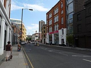
The street, in St Luke's, Islington, runs east-west and forms part of the B100 road. At the west end it becomes Beech Street, with Silk Street running from the south of that junction, and Whitecross Street heading north. At its east end it meets Finsbury Square.
The western junction marks the boundary of the City of London with the London Borough of Islington: Whitecross Street and Chiswell Street (north and east) are in Islington, while Beech Street and Silk Street (west and south) are in the City.
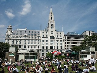
The southern block between Silk Street and Milton Street (once Grub Street) is occupied by the Grade II-listed Whitbread Brewery building. In 1750, Samuel Whitbread consolidated production from two smaller breweries, the Goat Brewhouse, where porter was produced, and a brewery in Brick Lane used to produce pale ale and amber ale, on a much larger site. Considerable expansion followed, and beer was brewed here for 225 years, until Whitbread Brewery closed in 1976. [2]
Part of the complex is now The Brewery, a conference and events venue, and part of it the Montcalm London City Hotel.
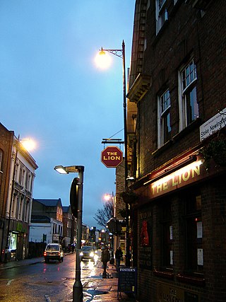
The Jugged Hare pub on the corner with Silk Street is also Grade II listed. [3]
William Caslon's Caslon Type Foundry was based on Chiswell Street for almost exactly two hundred years. [4]
Finsbury is a district of Central London, forming the southeastern part of the London Borough of Islington. It borders the City of London.

The New North Road is a road in northern central London, forming part of a link road from the A1 at Highbury into the City of London at Moorgate. It is 0.8 miles (1.3 km) in length and is part of the A1200. This link road consists of Canonbury Road and New North Road, before several smaller sections to the south leading into the city.

The Angel, Islington, is a historic landmark and a series of buildings that have stood on the corner of Islington High Street and Pentonville Road in Islington, London, England. The land originally belonged to the Clerkenwell Priory and has had various properties built on it since the 16th century. An inn on the site was called the "Angel Inn" by 1614, and the crossing became generally known as "the Angel". The site was bisected by the New Road, which opened in 1756, and properties on the site have been rebuilt several times up to the 20th century. The corner site gave its name to Angel tube station, opened in 1901, and the surrounding Angel area of London.

Arnold is a market town in the Borough of Gedling in the county of Nottinghamshire in the East Midlands of England. It is situated to the north-east of Nottingham's city boundary. Arnold has the largest town centre in the Borough of Gedling and the most important town centre in the northeastern part of the conurbation of Greater Nottingham. Gedling Borough Council is headquartered in Arnold. Since 1968 Arnold has had a market, and the town used to have numerous factories associated with the hosiery industry. Nottinghamshire Police have been headquartered in Arnold since 1979. At the time of the 2011 United Kingdom census, Arnold had a population of 37,768.
The EC postcode area, also known as the London EC postal area, is a group of postcode districts in central London, England. It includes almost all of the City of London and parts of the London boroughs of Islington, Camden, Hackney, Tower Hamlets and Westminster. The area covered is of very high density development. Deliveries for the EC postcode area are made from Mount Pleasant Mail Centre.
Whitbread is a British multinational hotel and restaurant company headquartered in Houghton Regis, England.

The Metropolitan Cattle Market, just off the Caledonian Road in the parish of Islington was built by the City of London Corporation and was opened in June 1855 by Prince Albert. The market was supplementary to the meat market at Smithfield and was established to remove the difficulty of managing live cattle at that latter site.

St Luke's is an area in London, England and is located in the London Borough of Islington. It lies just north of the border with the City of London near the Barbican Estate, and the Clerkenwell and Shoreditch areas.
Stoke Newington Church Street is a road in north London of the borough of Hackney. The road links Green Lanes (A105) in the west to Stoke Newington High Street, in the east. Stoke Newington is one of the villages swallowed by the growth of London in the 19th century, and Church Street retains some of this neighbourhood feel, with many restaurants, pubs, and independent (non-chain) shops.

Bunhill Row is a street located in St Luke's, London Borough of Islington, London. The street runs north–south from Old Street to Chiswell Street. On the east side are the cemetery of Bunhill Fields and the open space of the Honourable Artillery Company's Artillery Ground.

The A405 is a 4.8 miles dual carriageway road in Hertfordshire, England, from the A41 at Leavesden Green, near Watford, to the A414 at Park Street Roundabout near St Albans.
The A400 road is an A road in London that runs from Charing Cross to Archway in North London. It passes some of London's most famous landmarks.

Silk Street is a street in the City of London, England. It runs north–south, and then west–east, from the junction with Beech Street (west), Chiswell Street (east) and Whitecross Street, to Moor Lane.
Whitecross Street is a short street in Islington, in Inner London. It features an eponymous street market and a large housing estate.
Golden Lane, originally known as Goldeslane or Goldyng Lane, then Golding Lane, is a street in the City of London, England, that runs north–south, between Old Street in the north, and Beech Street in the south. It dates back to at least 1274 and was the site of Edward Alleyn's Fortune Theatre that was built in 1600. The street was almost completely destroyed by bombing during the Second World War before being rebuilt in the post-war era.

Beech Street is a street in the City of London, England. It was formerly known as Beech Lane and was named after Nicholas de la Beche, a lieutenant of the Tower of London in the reign of Edward III in the 14th century.

The Montcalm Hotels are a group of luxury hotels in Central London, United Kingdom.

The Jugged Hare is a public house and restaurant at 49 Chiswell Street, between Barbican and Moorgate underground stations in the City of London.