Related Research Articles

Okanagan Lake is a lake in the Okanagan Valley of British Columbia, Canada. The lake is 135 km (84 mi) long, between 4 and 5 km wide, and has a surface area of 348 km2.

The Regional District of Central Okanagan (RDCO) is a regional district in the Canadian province of British Columbia, representing two unincorporated Electoral Areas of Central Okanagan East and Central Okanagan West, along with the member municipalities of the City of Kelowna, City of West Kelowna, the District of Lake Country, the District of Peachland, and Westbank First Nation. The RDCO office is located in Kelowna.

Westbank is one of the communities within the City of West Kelowna in the province of British Columbia. It is 12 km to the west of Kelowna. Other communities in West Kelowna include Casa Loma, West Kelowna Estates, Shannon Lake, Smith Creek, Glenrosa, Rose Valley and Lakeview Heights. Westbank sits to the south of West Kelowna.
The basin of the Shuswap River lies northeast of the Okanagan Valley in British Columbia, originating in the central Monashee Mountains. It is the upper part of the drainage better known to British Columbians as belonging to Shuswap Lake and the South Thompson River. The river's drainage basin is over 1,969 square kilometres (760 sq mi) in area.
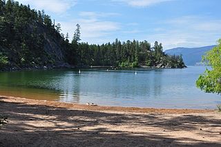
Ellison Provincial Park is a provincial park in British Columbia, Canada, located on the east side of Okanagan Lake to the south of the city of Vernon. The park contains approximately 219 hectares (2.19 km2) of land, 200 ha. of it upland, 19 ha. of it foreshore.

Kalamalka Lake Provincial Park and Protected Area is a provincial park in Coldstream, British Columbia, Canada. Located within the Okanagan region, the park encompasses a land area of about 978 hectares of pristine natural areas in the North Okanagan Regional District. Kalamalka Lake Provincial Park and Protected Area adopted its current name from Kalamalka Lake, for which it is located on its shore. During the process of entering summer, calcium carbonate forms crystals that reflect sunlight and create the vivid blue and green colours. Temperature changes in the fall and the spring sometimes create ribbons of deep blue colour in the lake, seen from the park.
Shuswap Lake Marine Provincial Park is a provincial park in British Columbia, Canada, comprising 894 ha. The Park has a variety of amenities including boat launch ramps, picnic areas, and 27 campsites around the perimeter of Shuswap Lake. The lake's name and that of the surrounding Shuswap Country is from the Shuswap people (Secwepemc), the most northern of the Salishan speaking people.

Mount Boucherie is a mountain located in West Kelowna on the west shore of Okanagan Lake, British Columbia, Canada, opposite the city of Kelowna. It is the remnants of a former stratovolcano created nearly 60 million years ago. Between four and six different glacial periods over the past 50 million years have eroded the volcano to produce Mount Boucherie. Though it now only rises 417 metres above the nearby lake level, it is estimated to once have had an elevation of 2,000 m (6,562 ft) or more.
The Lower Similkameen Indian Band or Lower Smelqmix, is a First Nations band government in the Canadian province of British Columbia. Their office was in the village of Keremeos in the Similkameen region, until 2015 when they moved into their own $7million multi-purpose facility south of Cawston. They are a member of the Okanagan Nation Alliance.
The Okanagan Indian Band is a First Nations government in the Canadian province of British Columbia, located in the city of Vernon in the northern Okanagan Valley. The band is a member government of the Okanagan Nation Alliance.

West Kelowna, formerly known as Westside and colloquially known as Westbank, is a city in British Columbia's Okanagan Valley on the west shore of Okanagan Lake. The city encompasses several neighbourhoods, including Casa Loma, Gellatly, Glenrosa, Lakeview Heights, Shannon Lake, Smith Creek, Rose Valley, Westbank, and West Kelowna Estates. As of 2021, West Kelowna had an estimated population of 36,078.

The Shuswap Country, or simply the Shuswap and called Secwepemcúl̓ecw in Secwepemctsín, is a term used in the Canadian province of British Columbia to refer to the environs of Shuswap Lake. The upper reaches of the Shuswap basin, southeast of Shuswap Lake and northeast of the Okanagan, are generally considered to be part of Okanagan or of the Monashee Country rather than "the Shuswap". Roughly defined, the Shuswap Country begins on its west at the town of Chase, located on Little Shuswap Lake, west of which is the South Thompson area of the Thompson Country, and includes Adams Lake to the northwest of Shuswap Lake as well as communities in the Eagle River area as far as Craigellachie and/or Three Valley Gap, which is at the summit of Eagle Pass, beyond which eastwards is the Columbia Country.
Shingle Creek is an unincorporated community in the southeastern Thompson Plateau of the Southern Interior of British Columbia, named after the stream of the same name, a tributary of the Okanagan River which joins that stream in the city of Penticton.

BX Falls is a small waterfall just northeast of Vernon, British Columbia, Canada, in electoral area C in the Regional District of North Okanagan. It is located just downstream from Tillicum Road's crossing of BX Creek. The falls are located in between Tillicum Road and Star Road, both of which branch off Silverstar Road. A trail runs between the two roads and a short side trail descends into the canyon off the main trail and allows visitors to see the falls up close.
Harris Creek is a creek in the Okanagan region of British Columbia. The creek is located to the south of the village of Lumby in the North Okanagan. Harris Creek has been mined for gold. The total output mined for Harris Creek amounts to $125,000.
Lambly Creek, also known as Bear Creek, is located in the Okanagan region of British Columbia. The creek flows into Okanagan Lake from the west, across from Kelowna. The canyon and mouth of the creek are protected by Bear Creek Provincial Park.
Naswhito Creek is located in the Okanagan region of British Columbia. The creek flows into Okanagan Lake from the west. Naswhito Creek is located a few miles south of Vernon, British Columbia. The creek is also called Siwash Creek which should not be confused with Siwash Creek near Princeton, British Columbia. Naswhito Creek has been mined for gold.
Testalinden Creek is a watercourse that flows east into the Okanagan River, south of the Okanagan town of Oliver, British Columbia. The Testalinden Dam was at the headwaters of this creek prior to the dam's failure in June 2010.
Inkaneep is an unincorporated community located on the east side of the Okanagan River within Osoyoos Indian Reserve No. 1, between the towns of Oliver and Osoyoos, British Columbia, Canada, in that province's South Okanagan region.
The Kootenay Land District is a cadastral survey subdivision of the province of British Columbia, Canada, created with rest of those on Mainland British Columbia via the Lands Act of the Colony of British Columbia in 1860. The British Columbia government's BC Names system, a subdivision of GeoBC, defines a land district as "a territorial division with legally defined boundaries for administrative purposes" All land titles and surveys use the Land District system as the primary point of reference, and entries in BC Names for placenames and geographical objects are so listed.
References
- ↑ "Parker Cove" . Retrieved 1 May 2022.
- ↑ N.L. Barlee (1973), Gold Creeks and Ghost Towns, Canada West Publications