Whorehouse Meadow

Last updated

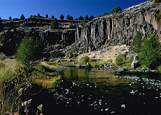
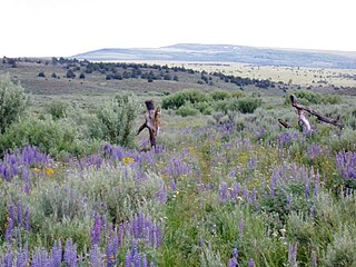
Whorehouse Meadow [1] is a meadow located on the western slope of Steens Mountain southeast of Frenchglen, Oregon, United States. It lies within the Steens Mountain Wilderness. Lewis McArthur, writing about the landmark in Oregon Geographic Names , describes it as an "accessible but secluded meadow a mile east of Fish Lake." [2]

Meadow field vegetated primarily by grass and other non-woody plants (grassland)

A meadow is an open habitat, or field, vegetated by grass and other non-woody plants. They attract a multitude of wildlife and support flora and fauna that could not thrive in other conditions. They provide areas for courtship displays, nesting, food gathering, pollinating insects, and sometimes sheltering, if the vegetation is high enough, making them ecologically important. There are multiple types of meadows, such as agricultural, transitional, and perpetual, each important to the ecosystem. Meadows may be naturally occurring or artificially created from cleared shrub or woodland.

Steens Mountain mountain in United States of America

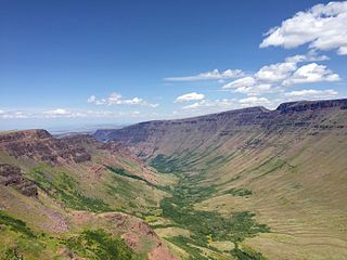
Steens Mountain is in the southeastern part of the U.S. state of Oregon, and is a large fault-block mountain, Located in Harney County, it stretches some 50 miles (80 km) north to south, and rises from alongside the Alvord Desert at elevation of about 4,200 feet (1,300 m) to a summit elevation of 9,733 feet (2,967 m). It is sometimes confused with a mountain range but is properly a single mountain.

Frenchglen, Oregon Unincorporated community in Oregon, United States

Frenchglen is an unincorporated community in Harney County, Oregon, United States. It is 60 miles (97 km) south of Burns on Oregon Route 205 and its population is approximately 12.

The meadow acquired its name in the days of the Old West. Entrepreneuring women from Vale, Oregon, would set up wood and canvas tents in the meadow to provide services to the sheepherders and cattlemen of the area. Many of the sheepherders were Basque American immigrants, and their sometimes explicit carvings can still be found in the bark of aspen trees surrounding the meadow. The name was changed in the 1960s to "Naughty Girl Meadow" on Bureau of Land Management maps, but in 1981 the old name was restored after public outcry. [3] Whorehouse Meadow has frequently been noted on lists of unusual place names. [4] [5]

Vale, Oregon City in Oregon, United States

Vale is a city in and the county seat of Malheur County, Oregon, United States, about 12 miles (19 km) west of the Idaho border. It is at the intersection of U.S. Routes 20 and 26, on the Malheur River at its confluence with Bully Creek.
Bureau of Land Management agency within the United States Department of the Interior

The Bureau of Land Management (BLM) is an agency within the United States Department of the Interior that administers more than 247.3 million acres (1,001,000 km2) of public lands in the United States which constitutes one eighth of the landmass of the country. President Harry S. Truman created the BLM in 1946 by combining two existing agencies: the General Land Office and the Grazing Service. The agency manages the federal government's nearly 700 million acres (2,800,000 km2) of subsurface mineral estate located beneath federal, state and private lands severed from their surface rights by the Homestead Act of 1862. Most BLM public lands are located in these 12 western states: Alaska, Arizona, California, Colorado, Idaho, Montana, Nevada, New Mexico, Oregon, Utah, Washington and Wyoming.

Place names considered unusual Wikimedia list article

Unusual place names are names for cities, towns, and other regions which are considered non-ordinary in some manner. This can include place names which are also swear words, inadvertently humorous or highly charged words, as well as place names of unorthodox spelling and pronunciation, including especially short or long names.
Further reading

Related Research Articles

Marys River (Oregon) river in Oregon

Marys River is a 40-mile (64 km) tributary of the Willamette River in the U.S. state of Oregon. From its source at the confluence of its east and west forks near Summit, it flows generally southeast from the Central Oregon Coast Range to Corvallis.

Alvord Desert desert in southeastern Oregon

The Alvord Desert is a desert located in Harney County, in southeastern Oregon in the western United States. It is roughly southeast of Steens Mountain. The Alvord Desert is a 12-by-7-mile dry lake bed and averages 7 inches (180 mm) of rain a year. Two mountain ranges separate it from the Pacific Ocean—the Coast Range, and the Cascade Mountains. Along with Steens Mountain, these topographical features create a rain shadow. The Alvord Desert lies at an elevation of approximately 4,000 feet (1,200 m).

Mark Stephen Monmonier is a Distinguished Professor of Geography at the Maxwell School of Syracuse University. He specializes in toponymy, geography, and geographic information systems. His popular written works show a combination of serious study and a sense of humor. Most of his work is published by University of Chicago Press. He has appeared on National Public Radio interview programs.

Donner und Blitzen River river in the United States of America

The Donner und Blitzen River is a river on the eastern Oregon high desert which drains a relatively arid basin, the southern portion of Harney Basin, from roughly 20 to 80 miles south-southeast of Burns including Malheur National Wildlife Refuge. Though much of its course is marsh, it offers scenic glaciated canyons, unique ecosystems, and exceptional wild trout fisheries. Named by soldiers of German origin, the Donner und Blitzen River translates as "thunder and lightning". The name usually brings to mind two of Santa Claus' reindeer, but the river is named for a thunderstorm the soldiers experienced as they crossed the river; dry lightning is an almost daily occurrence in the region during certain times of the year.

Hart Mountain mountain

Hart Mountain is a fault-block mountain, in Lake County, Oregon, U.S. It lies about 30 miles (48 km) to the east of Lakeview.

Crane, Oregon Census-designated place in Oregon, United States

Crane is a census-designated place and unincorporated community in Harney County, Oregon, United States, northeast of Malheur Lake on Oregon Route 78. Its population was 129 at the 2010 census.

Steens Mountain Wilderness

The Steens Mountain Wilderness is a wilderness area surrounding a portion of Steens Mountain of southeastern Oregon in the United States. The reserve falls within the Steens Mountain Cooperative Management and Protection Area (CMPA). Both the reserve and the CMPA are administered by the Bureau of Land Management. The wilderness area encompasses 170,166 acres (68,864 ha) of the CMPA's total 428,156 acres (173,269 ha). 98,859 acres (40,007 ha) of the Wilderness are protected from grazing and free of cattle.

Gearhart Mountain Wilderness

Gearhart Mountain Wilderness is a wilderness area located within the Fremont–Winema National Forest in Lake County and Klamath County in south-central Oregon. This area was established in 1943 as a Wild Area and designated as wilderness with the Wilderness Act of 1964. In 1984, an additional 4,144 acres (1,677 ha) were added for a total of 22,823 acres (9,236 ha). The wilderness is entirely within the Bly Ranger District.

Little Blitzen River watercourse in the United States of America

Little Blitzen River is a 12.5-mile (20.1 km) tributary of the Donner und Blitzen River in the U.S. state of Oregon. Little Blitzen River rises on the west flank of Steens Mountain about 20 miles (32 km) southeast of Frenchglen and about 70 miles (110 km) south of Burns in Harney County. Flowing west in a steep-walled canyon, it joins the South Fork Donner und Blitzen River at 42.6737752°N 118.7935277°W to form the Donner und Blitzen main stem, which continues north about another 40 miles (64 km) to its mouth at 43.291542°N 118.8199273°W in Malheur Lake. The Donner und Blitzen River was named by soldiers of German origin and translates as "thunder and lightning". Little Blitzen River brings to mind one of Santa Claus's reindeer.

Pueblo Mountains mountain range in the United States

The Pueblo Mountains are a remote mountain range in the United States located mostly in southeastern Oregon and partially in northwestern Nevada. The highest point in the range is Pueblo Mountain. The dominant vegetation throughout is grasses and big sagebrush; however, there are meadows with cottonwood, aspen, and willow groves along some stream drainages. Most of the range is public land administered by the Bureau of Land Management. There is very little human development in the Pueblo Mountains, and most visitors come for backpacking cross-country, camping, and hunting.

Orodell, also known as Oro Dell, is an unincorporated historic community in Union County, Oregon, United States, on the Grande Ronde River at the northwest edge of La Grande. It is considered a ghost town. Either Charles Fox or Stephen Coffin started the first sawmill in the Grande Ronde Valley there in the summer of 1862, after a joint-stock company between Coffin and other local settlers failed to materialize in 1861.

Susanville is an unincorporated community in Grant County, Oregon, United States, in the Blue Mountains about two miles up Elk Creek from Galena. The place was started as a gold mining camp in 1862 or 1864 and is now considered a ghost town.

Donnybrook, Oregon Unincorporated community in Oregon, United States

Donnybrook is a historic unincorporated community in Jefferson County, Oregon, United States. Donnybrook is located about 20 miles south of Antelope, and 10 miles east of Ashwood. The area was first known as "Axehandle", and later as "Kilts".

Kiger Creek (Harney County, Oregon) river in the United States of America

Kiger Creek is a tributary of Swamp Creek in Harney County in the U.S. state of Oregon. It originates on Steens Mountain and flows generally north through Kiger Gorge to meet Swamp Creek near the unincorporated community of Diamond. The combined streams flow into Diamond Swamp and the Malheur National Wildlife Refuge.

Catlow Valley valley in Harney County, United States of America

The Catlow Valley is a basin in Harney County, Oregon, United States. It is a remote valley at the northwestern corner of North America's Basin and Range Province. The valley is named after a pioneer rancher, John Catlow. The area was used by Native Americans for thousands of years before European explorers arrived in the 19th century. Today, cattle ranching is the main commercial activity in the valley. The public land in the Catlow Valley is administered by the Bureau of Land Management. This public land offers a number of recreational opportunities including hiking, hunting, fishing, bird watching, and wildlife viewing.

Jew Peak is a summit in Sanders County, Montana, in the United States. It has an elevation of 5,853 feet (1,784 m). Jew Peak is the 2,010th highest mountain in the state of Montana.

Coon Butt is a summit in Blount County, Tennessee, in the United States. It is located within Great Smoky Mountains National Park. With an elevation of 2,326 feet (709 m), Coon Butt is the 422nd highest mountain of Tennessee.

Brilliant is an unincorporated community in Colfax County, in the U.S. state of New Mexico.

Jewfish Point is a cape in Los Angeles County, in the U.S. state of California. It is located on the Southeast coast of Santa Catalina Island.

References

  1. U.S. Geological Survey Geographic Names Information System: Whorehouse Meadow
  2. "Whorehouse Meadow", in McArthur, Oregon Geographic Names, 5th edition (Portland: Western Imprints (Oregon Historical Society), 1982), p. 793
  3. "The word: Whorehouse meadow (excerpt)". New Scientist. 5 August 2006. Retrieved 8 June 2014.
  4. Parker, Quentin (2010). Welcome to Horneytown, North Carolina, Population: 15: An insider's guide to 201 of the world's weirdest and wildest places. Adams Media. pp. xii. ISBN   9781440507397.
  5. From Intercourse, Pa., to Monkey’s Eyebrow, Ky., how U.S. places got their names

Coordinates: 42°43′50″N118°37′49″W / 42.7306°N 118.6304°W / 42.7306; -118.6304

Geographic coordinate system Coordinate system

A geographic coordinate system is a coordinate system that enables every location on Earth to be specified by a set of numbers, letters or symbols. The coordinates are often chosen such that one of the numbers represents a vertical position and two or three of the numbers represent a horizontal position; alternatively, a geographic position may be expressed in a combined three-dimensional Cartesian vector. A common choice of coordinates is latitude, longitude and elevation. To specify a location on a plane requires a map projection.