Wide Bay Military Reserve

Last updated

Wide Bay Military Reserve
Australia Queensland relief location map.jpg
Red pog.svg
Location of Wide Bay Military Reserve in Queensland
LocationTin Can Bay Road, Tin Can Bay, Queensland, Australia
Coordinates 25°52′24″S152°56′05″E / 25.8733°S 152.9348°E / -25.8733; 152.9348
Official nameWide Bay Military Reserve
TypeListed place (Natural)
Designated22 June 2004
Reference no.105285

Wide Bay Military Reserve is a heritage-listed military installation at Tin Can Bay Road, Tin Can Bay, Queensland, Australia. The reserve supports a diverse range of plant communities from estuarine, strand (including coastal marshes and pockets of rainforest), wetlands, heath, tall shrublands and woodlands, to the open forests of the sub-coastal hills and ranges. The total number of bird species recorded for the place totals 250, which is high by Australian standards. It was added to the Australian Commonwealth Heritage List on 22 June 2004. [1]

Contents

History

The Wide Bay area is a military training area and has been used intensively by artillery regiments and infantry battalions employing armoured vehicles. [1]

Description

Wide Bay Military Reserve is approximately 22,300 hectares (55,000 acres), 1 kilometre (0.62 mi) north-west of Tin Can Bay. It forms a continuum of natural environment with Fraser Island and the Cooloola National Park. [1]

The Wide Bay area is the northernmost extension of the Cooloola sand dune mass, deposited intermittently with changing sea levels, over the last 150,000 years. The oldest dunes, in the central portion of the Wide Bay area, have been weathered and partially inundated to form a low lying undulating landscape. The soils here are shallow, sandy and low in nutrients and overlie heavy clay. Drainage is therefore slow, the water table is consistently close to the surface, and marshes and bogs are common. These wetter areas are known as wallum, and are dominated by open sedgeland and Banksia heathland, which grade into patchy forests and woodland on the upper dune slopes and crests. Common forest and woodland trees are White Mahogany ( Eucalyptus umbra ), Pinkwood (Eucalyptus internmedia) and Broad leaved Paper-bark ( Melaleuca quinquenervia ). Major heath species include Acacia ulicifolia , Banksia aemula , Banksia robur , Melaleuca juniperinum and Leucopogon pedicellatus . Sedges form the dominant understorey plant of the forests and woodlands. [1]

The old dunes are underlain by coarse grained Triassic (200 million year old) sandstones which outcrop in the western section of the Wide Bay area in the form of dissected ridges of moderate relief. The steep slopes and crests support tall open forests, in which Smooth-barked Apple ( Angophora costata ), Turpentine ( Syncarpia glomulifera ), Ironbark ( Eucalyptus crebra ), Forest Oak ( Casuarina torulosa ) and Black Oak ( Casuarina littoralis ) are dominant. The Yellow Tailed Black Cockatoo (Calyptorhynchus funereusis) is common in the forest and black oak stands. [1]

The eastern section of the Wide Bay area consists of recent dunes less than 10,000 years old and tidal channels and flats. Salt pans, support water couch (Sporobolus viginicus), occur where tidal cover is very shallow and surface evaporation high. On higher ground surrounding the saltflats, are open forest of swamp She-oak ( Casuarina glauca ), Moreton Bay Ash ( Eucalyptus tessellaris ), Blue Gum (Eucalyptus tereticornis) and Cabbage Tree Palm (Livistonia australis). Mangroves occur on the estuarine and sea-birds and waders such as the Caspian Tern ( Hydroprogne caspia ), Eastern Reef Egret (Egretta sacrea), Ibis (Threskiornis aethiopica, Threskiornis spinicollis ) and Spoonbill ( Platalea regia ). During the summer this area is an important overwintering site of migrant waders from the Northern Hemisphere. The relatively young dunes of this area support species include Piccabeen Palms ( Archontophoenix cunninghamiana ), Coast Cypress (Callitris columellaria) and Brushbox ( Lophostemon confertus ).

The seaward side of the Wide Bay Area is continuous with the Great Sandy Strait region, which is heritage-listed in its own right. [1]

Condition

As at 1988, the area was in good to excellent condition; however some areas have been disturbed by military exercises within the training areas, and at the settlement at Camp Kerr. Most disturbance appears to be along and bordering ridgetop roads, which are used for tank exercises. CSIRO monitors disturbance and revegetation following such exercises to minimise impacts, and to develop "no go" rules following periods of rainfall. The reserve is noted for being relatively weed free with only minor infestations of Lantana and Groundsel ( Baccharis hamilifolia ), both of which are rampant in many other areas throughout the region. Some exotic cover crops are used by the army to minimise soil erosion following exercises but these have not as yet become invasive. There has been some logging of Callitris Columellaris from accessible areas but good stands of Callitris Columellaris and Lophostemon suaveolons are found within the area. [1]

Heritage listing

The Wide Bay Military Reserve supports a diverse range of plant communities from estuarine, strand (including coastal marshes and pockets of rainforest), wetlands, heath, tall shrublands and woodlands, to the open forests of the sub-coastal hills and ranges. The place contains a representative example of the coastal lowland complex known as "wallum". The patches of coastal rainforest are a valuable remnant of a formerly more widespread vegetation complex. Wide Bay represents the northern and southern range limits for a number of flora and fauna species. The place provides an important refuge for palaearctic migrant birds, including several identified in the Japan Australia migratory bird agreement. The intertidal areas are an integral part of the Great Sandy Strait, which is one of the most important wader habitats in Queensland. The total number of bird species recorded for the place totals 250, which is high by Australian standards. The reserve provides important habitat for the Ground Parrot, (Pezoporus wallicus), which is endangered in Queensland.

Wide Bay Military Reserve was listed on the Australian Commonwealth Heritage List on 22 June 2004 having satisfied the following criteria. [1]

Criterion A: Processes

Tin Can Inlet includes mangrove species near their southern range limit including Aegialitis annulata and Osbornia octodonta. [2] Wide Bay represents the most northerly occurrence of the yellow form of Christmas Bells (Blandfordia grandiflora) on the mainland. The area supports one of the few remaining strongholds for the species in Queensland. [3] A significant southern extension of the known range of the Fairy Gerygone, Gerygone palpebrosa , is found in the transitional open forests. [4] [1]

Criterion B: Rarity

The heathlands of Wide Bay are the major Queensland habitat of the Ground Parrot, Pezoporus wallicus, which is endangered in Queensland. [5] The area supports a significantly high population density of this species. [6] Patches of coastal rainforest in the far north-east of the area are a valuable remnant of a once widespread coastal vegetation complex. [7] [1]

Criterion D: Characteristic values

The Wide Bay area contains a representative example in good condition of the coastal lowland complex described by Coaldrake (1961) and known as "Wallum". Coaldrake identified 20 landscapes within this complex remaining on the coastal lowland between Gladstone and Brisbane. Wide Bay contains a major proportion of the "Tin Can" landscape, and as such represents the most significant example of this particular landscape. [1]

Vegetation communities within the area are of high integrity and diversity, and include closed to open forests, woodlands, heath species with shrubs and low trees with Wallum indicator species such as Banksia aemula, and B.robur, and littoral vegetation. Communities are relatively undisturbed, with only two significant weed species occurring away from areas of human settlement. [7] [1]

Communities of particular interest include: the estuarine/littoral vegetation sequence, representative of much of the coastal region of south-east Queensland, with mangrove forests, exposed salt pans, coastal marshes, and tea-tree swamps; and the coastal dune rainforest complex which has remained in unusually good condition due to its relative inaccessibility; the rainforest represents a complex that was once widespread along the Queensland coast. [7] [1]

Related Research Articles

<span class="mw-page-title-main">Royal National Park</span> Protected area in New South Wales, Australia

The Royal National Park is a protected national park that is located in Sutherland Shire in the Australian state of New South Wales, just south of Sydney.

<span class="mw-page-title-main">Blue Lake National Park</span> Protected area in Queensland, Australia

Blue Lake National Park was a former protected area in Queensland, Australia, located on North Stradbroke Island about 44 kilometres (27 mi) east of Brisbane. Blue Lake National Park is now a part of the Naree Budjong Djara National Park. Access was provided by road 9 kilometres (5.6 mi) west of Dunwich.

<span class="mw-page-title-main">Glass House Mountains National Park</span> Protected area in Queensland, Australia

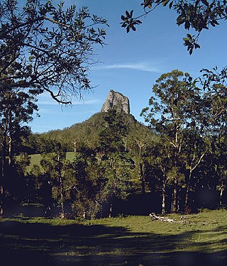
Glass House Mountains National Park is a heritage-listed national park at Glass House Mountains, Sunshine Coast Region, Queensland, Australia. It is also known as Beerburrum Forest Reserve 1. It is 70 km (43 mi) north of Brisbane and consists of a flat plain punctuated by rhyolite and trachyte volcanic plugs, the cores of extinct volcanoes that formed 26 million to 27 million years ago. The mountains would once have had pyroclastic exteriors, but these have eroded away.

<span class="mw-page-title-main">Mooloolah River National Park</span> Protected area in Queensland, Australia

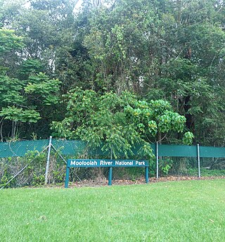
The Mooloolah River National Park is a nationally protected area located on the Sunshine Coast, Queensland. It covers an area of 830.9 hectares and is bordered by the Mooloolah River to the east, Claymore and Dixon Roads to the west, and the Lower Mooloolah River Environmental Reserve to the south. It is bisected by the Sunshine Motorway with the northern, 161.93 hectare component of the Park being a later addition. The Park was initially vacant crown land prior to national park designation in 1960. Surrounding land uses include livestock grazing, urban development and the campus of the University of the Sunshine Coast. It is the second largest mainland park on the coastal lowlands in South East Queensland after Noosa National Park and represents an example of low-lying coastal floodplain distinctive of the region.

<span class="mw-page-title-main">Beecroft Peninsula</span>

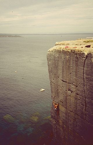
Beecroft Peninsula is the northern headland of Jervis Bay, on Australia's east coast. On the western and southern sides of the peninsula steep sandstone cliffs rise out of the ocean, up to 91 metres at its southernmost point, Point Perpendicular. White sandy beaches are found along the northern, eastern and southern sides interspersed with numerous intertidal reefs.

<i>Banksia aemula</i> Shrub of the family Proteaceae found on the Australian east coast

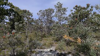
Banksia aemula, commonly known as the wallum banksia, is a shrub of the family Proteaceae. Found from Bundaberg south to Sydney on the Australian east coast, it is encountered as a shrub or a tree to 8 m (26 ft) in coastal heath on deep sandy soil, known as Wallum. It has wrinkled orange bark and shiny green serrated leaves, with green-yellow flower spikes, known as inflorescences, appearing in autumn. The flower spikes turn grey as they age and large grey follicles appear. Banksia aemula resprouts from its woody base, known as a lignotuber, after bushfires.

Shoalwater Bay Military Training Area is a heritage-listed military installation at Byfield Road, Byfield, Shire of Livingstone, Queensland, Australia. It is a large, relatively undisturbed and intact natural system with a wide variety of coastal landforms and a high level of biodiversity. It contains a diverse range of marine and coastal wetland landscapes, vegetation types and ecosystems. It was added to the Australian Commonwealth Heritage List on 22 June 2004.

<span class="mw-page-title-main">Cumberland Plain</span> Plain in Australia

The Cumberland Plain, an IBRA biogeographic region, is a relatively flat region lying to the west of Sydney CBD in New South Wales, Australia. Cumberland Basin is the preferred physiographic and geological term for the low-lying plain of the Permian-Triassic Sydney Basin found between Sydney and the Blue Mountains, and it is a structural sub-basin of the Sydney Basin.

<span class="mw-page-title-main">Warren bioregion</span> Biogeographic region in southern Western Australia

Warren, also known as Karri Forest Region and the Jarrah-Karri forest and shrublands ecoregion, is a biogeographic region in southern Western Australia. Located in the southwest corner of Western Australia between Cape Naturaliste and Albany, it is bordered to the north and east by the Jarrah Forest region. Its defining characteristic is an extensive tall forest of Eucalyptus diversicolor (karri). This occurs on dissected, hilly ground, with a moderately wet climate. Karri is a valuable timber and much of the karri forest has been logged over, but less than a third has been cleared for agriculture. Recognised as a region under the Interim Biogeographic Regionalisation for Australia (IBRA), and as a terrestrial ecoregion by the World Wide Fund for Nature, it was first defined by Ludwig Diels in 1906.

<span class="mw-page-title-main">Flora of Australia</span> Plant species of Australia

The flora of Australia comprises a vast assemblage of plant species estimated to over 21,000 vascular and 14,000 non-vascular plants, 250,000 species of fungi and over 3,000 lichens. The flora has strong affinities with the flora of Gondwana, and below the family level has a highly endemic angiosperm flora whose diversity was shaped by the effects of continental drift and climate change since the Cretaceous. Prominent features of the Australian flora are adaptations to aridity and fire which include scleromorphy and serotiny. These adaptations are common in species from the large and well-known families Proteaceae (Banksia), Myrtaceae, and Fabaceae.

<span class="mw-page-title-main">Eastern Australian temperate forests</span> Ecoregion in Australia

The Eastern Australian temperate forests is a broad ecoregion of open forest on uplands starting from the east coast of New South Wales in the South Coast to southern Queensland, Australia. Although dry sclerophyll and wet sclerophyll eucalyptus forests predominate within this ecoregion, a number of distinguishable rainforest communities are present as well.

<span class="mw-page-title-main">Wide Bay–Burnett</span> Region in Queensland, Australia

Noosa Biosphere Reserve is an internationally protected area covering the region of Noosa in Queensland, Australia. It is formally recognised as a Biosphere Reserve by the United Nations Education, Scientific and Cultural Organization (UNESCO) and Man and the Biosphere (MAB) program for its highly diverse ecosystem over a relatively small space. It was the first Biosphere Reserve for the state of Queensland, established in September 2007. The reserve is bound by the Noosa Shire Council boundaries, extending offshore by 3 kilometres (1.9 mi), covering 150,000 hectares in total. It is governed by Noosa Biosphere Limited (NBL), a not-for-profit company, which mainly consists of members from the local community who fulfil roles in the governance board, sector boards, and partnerships. Community plays a significant role in the implementation of the Biosphere Reserve guidelines.

Tasmania can be broadly divided into two distinct regions, eastern and western, that exhibit major differences in climate, geology and vegetation. This divide, termed Tyler’s Corridor, runs from just south of the northwestern corner, and continues south, cutting roughly down the center of the island. The vegetation changes occur principally due to variations in soil types, which are a result of the geological composition, and the vast difference in climate across the state. Generally, the west has a higher mean rainfall but poor acidic soil while the east has a lower mean rainfall but slightly more fertile soil. This results in a larger proportion of rainforest, moorland and wet sclerophyll vegetation dominating in the west and predominantly dry sclerophyll in the east.

<span class="mw-page-title-main">Ecology of Sydney</span> Geographic aspect of Sydney, Australia

The ecology of Sydney, located in the state of New South Wales, Australia, is diverse for its size, where it would mainly feature biomes such as grassy woodlands or savannas and some sclerophyll forests, with some pockets of mallee shrublands, riparian forests, heathlands, and wetlands, in addition to small temperate rainforest fragments.

Tully Training Area is a heritage-listed rainforest in a military training area at Tully-Cardstone Road, Tully, Queensland, Australia. It was added to the Australian Commonwealth Heritage List on 22 June 2004.

<span class="mw-page-title-main">Eastern Suburbs Banksia Scrub</span> Indigenous woodland community in Sydney, Australia

The Eastern Suburbs Banksia Scrub, which also incorporates Sydney Coastal Heaths, is a remnant sclerophyll scrubland and heathland that is found in the eastern and southern regions of Sydney, New South Wales, Australia. Listed under the Environment Protection and Biodiversity Conservation Act 1999 as and endangered vegetation community and as 'critically endangered' under the NSW Biodiversity Conservation Act 2016, the Eastern Suburbs Banksia Scrub is found on ancient, nutrient poor sands either on dunes or on promontories. Sydney coastal heaths are a scrubby heathland found on exposed coastal sandstone plateau in the south.

<span class="mw-page-title-main">Banksia Woodlands of the Swan Coastal Plain</span> Indigenous woodland community in Western Australia

The Banksia Woodlands of the Swan Coastal Plain is a protected sclerophyll community situated in the Swan Coastal Plain, Western Australia that predominantly consists of banksias. Listed as endangered under the Environment Protection and Biodiversity Conservation Act 1999, it was once a near-incessant band of large shrub patches around Perth and other nearby coastal areas.

References

  1. 1 2 3 4 5 6 7 8 9 10 11 12 13 "Wide Bay Military Reserve (Place ID 105285)". Australian Heritage Database . Australian Government . Retrieved 15 May 2019.
  2. McDonald and Elson 1984
  3. Carolyn Sandercoe QNPWS, pers. comm.
  4. Nix (1988)
  5. Dept. of Environment &Heritage 1991
  6. Nix, in Bell 1985
  7. 1 2 3 Gillison 1988

Bibliography

Attribution

CC BY icon-80x15.png This Wikipedia article was originally based on Wide Bay Military Reserve , entry number 105285 in the Australian Heritage Database published by the Commonwealth of Australia 2019 under CC-BY 4.0 licence , accessed on 15 May 2019.