This article needs additional citations for verification .(August 2013) |
Wien | |
---|---|
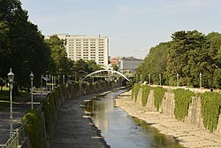
![]() The Wien in the Stadtpark | |
![]() | |
Location | |
Country | Austria |
Physical characteristics | |
Source | |
• location | Kaiserbrunnberg near Rekawinkel in Lower Austria |
• elevation | 520 m (1,710 ft) |
Mouth | |
• location | Donaukanal (Danube) in Vienna |
• coordinates | 48°12′43″N16°23′04″E / 48.21194°N 16.38444°E |
Length | 34 km (21 mi) |
Basin size | 221 km2 (85 sq mi) |
Basin features | |
Progression | Danube→ Black Sea |
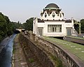
The Wien is a river that flows through the capital of Austria, Vienna.
The river Wien is 34 kilometres (21 mi) long, of which 15 km (9.3 mi) are within the city. Its drainage basin covers an area of 221 km2 (85 sq mi), [1] both in the city and in the neighbouring Vienna Woods. Its source lies in the western Vienna Woods near Rekawinkel and its mouth at the eastern end of the city centre of Vienna, next to the Urania, where it flows into the Donaukanal ("Danube Canal"), a branch of the Danube.
The Wien is subject to huge variations in flow. In its headwaters in the Vienna Woods, the soil is underlain by sandstone. Because of this, during heavy rain the soil quickly saturates, resulting in substantial runoff. Thus, the flow of the Wien can quickly increase from a creek-like 200 litres per second (7.1 cu ft/s) to 450,000 litres per second (16,000 cu ft/s) in the heaviest rains or during the spring snowmelt in the Vienna Woods, a ratio of over 1:2000.
Within the city limits, the river bed consists almost entirely of concrete, which was installed between 1895 and 1899 in order to stop the devastating floods, sometimes accompanied by cholera, which the river had regularly caused before that time. At the same time, the Stadtbahn ("city railway") was built, which makes use of the concrete river bed and is only separated from the river by a wall. It is now part of the Vienna U-Bahn system.
Along the course of the river, the Naschmarkt and the Theater an der Wien can be found. Much of the river is covered over in the city, particularly in front of Schönbrunn Palace, in the Meidling and Naschmarkt neighbourhoods and around Karlsplatz near the city centre. [2]
The River Gate was built in the years 1903 to 1906 and was opened to the general public on 15 November 1906. The gate forms one of the most beautiful Jugendstil scenes to be found in the city of Vienna.
In 2013, the City of Vienna approved plans to build three terraces along the river valley. Each terrace (or "zone") will cover a total area of 2,500 square metres (27,000 sq ft). [3] The first terrace was expected to be completed by 2015.
![]() | This article needs to be updated. The reason given is: 2015 has now since long passed.(January 2025) |
For safety reasons, cycling or walking in the concrete bed of the Wien is officially prohibited. A continually controversial topic is whether to build cycle paths and footpaths next to the water. Proponents believe the water flow can be safely regulated, while opponents do not believe this is possible. In 2005, a short segment was opened to the public, near Hütteldorf railway station. It features an audible and visual alarm system to warn users to leave the path if flooding is imminent. Extensions to this path have been proposed, but continue to receive much opposition. The path is open from March to October.
In German, the river is colloquially called the "Wienfluss". Since English uses the name "Vienna" for what in German is called "Wien", in English the river is sometimes called the "Vienna River".
Vienna is the capital, most populous city, and one of nine federal states of Austria. It is Austria's primate city, with just over two million inhabitants. Its larger metropolitan area has a population of nearly 2.9 million, representing nearly one-third of the country's population. Vienna is the cultural, economic, and political center of the country, the fifth-largest city by population in the European Union, and the most-populous of the cities on the Danube river.
The Aller is a 215-kilometre-long (134 mi) river in the states of Saxony-Anhalt and Lower Saxony in Germany. It is a right-hand, and hence eastern, tributary of the Weser and is also its largest tributary. Its last 117 kilometres (73 mi) form the Lower Aller federal waterway. The Aller was extensively straightened, widened and, in places, dyked during the 1960s to provide flood control of the river. In a 20-kilometre-long (12 mi) section near Gifhorn, the river meanders in its natural river bed.
The Lech is a river in Austria and Germany. It is a right tributary of the Danube 255 kilometres (158 mi) in length with a drainage basin of 3,919 square kilometres (1,513 sq mi). Its average discharge at the mouth is 115 m3/s (4,100 cu ft/s). Its source is located in the Austrian state of Vorarlberg, where the river rises from lake Formarinsee in the Alps at an altitude of 1,870 metres (6,120 ft). It flows in a north-north-easterly direction and crosses the German border, forming the Lechfall, a 12-metre-high (39 ft) waterfall; afterwards the river enters a narrow gorge. Leaving the Alps, it enters the plains of the Allgäu at Füssen at an elevation of 790 metres (2,580 ft) in the German state of Bavaria, where it used to be the location of the boundary with Swabia. The river runs through the city of Füssen and through the Forggensee, a man-made lake which is drained in winter. Here, it forms rapids and a waterfall.
The Timiș or Tamiš is a 359-kilometre-long (223 mi) river that flows through the Banat region of Romania and Serbia and joins the Danube near Pančevo, in northern Serbia. Due to its position in the region, it has been labeled as the "spine of the Banat".
The Vienna U-Bahn, where U-Bahn is an abbreviation of the German word Untergrundbahn, is a rapid transit system serving Vienna, Austria. The five-line network consists of 83.1 kilometers (51.6 mi) of route, serving 109 stations. 459.8 million passengers rode the U-Bahn in 2019.
The Durance is a major river in Southeastern France. A left tributary of the Rhône, it is 323.2 km (200.8 mi) long. Its drainage basin is 14,472 km2 (5,588 sq mi).
Rudolfsheim-Fünfhaus is the 15th municipal District of Vienna, Austria. It is in central Vienna, west of Innere Stadt.
The Sulm is a river in the Heilbronn district of Baden-Württemberg, Germany. It is an unnavigable right tributary of the Neckar. It rises in the Löwenstein Mountains and after 26.3 kilometres (16.3 mi) distance and 315 metres (1,033 ft) elevation drop flows into the Neckar at Bad Friedrichshall, near Untereisesheim and Neckarsulm. Its valley together with its tributary valleys is also known as the Weinsberg Valley, after Weinsberg, which is located there. The medieval region of Sulmgau, as well as the city of Neckarsulm, were named for it. The upper valley of the Sulm is a protected area.
The Donaukanal is a former arm of the river Danube, now regulated as a water channel, within the city of Vienna, Austria. It is 17.3 kilometres (10.7 mi) long and, unlike the Danube itself, it borders Vienna's city centre, Innere Stadt, where the Wien River (Wienfluss) flows into it.
The Vienna Stadtbahn was a rail-based public transportation system operated under this name from 1898 until 1989. Today, the Vienna U-Bahn lines U4 and U6 and the Vienna S-Bahn run on its former lines.
The Wienzeile is a street in Vienna, which originated in the course of the regulation of the Vienna River between 1899 and 1905 along the river's banks. It is divided into the Rechte Wienzeile and the Linke Wienzeile.
The Vienna Danube regulation refers to extensive flood-control engineering along the Danube river in Vienna, Austria during the last 150 years. The first major dams or levees were built during 1870-75. Another major project was constructed during 1972-88, which created the New Danube and Danube Island (Donauinsel). Prior to regulation, the Danube in Vienna had been an 8-kilometre (5 mi) wide wetlands, as a patchwork of numerous streams meandering through the area.
For a long time, it was not necessary to build a Harbour in Vienna, because the existing natural landing points were sufficient for the level of trade on the Danube. It was only when steamships began to arrive in great numbers that a harbour offering safe berths became essential. Even then however, goods were for the most part loaded and unloaded at an unenclosed river harbour that was established at the end of the 19th century.
The hydrology of Hungary, is mostly determined by Hungary's lying in the middle of the Carpathian Basin, half surrounded by the Carpathian Mountains. All parts of the country have some outflow. All surface water gravitates towards its southern center, and from there, is united in the Danube, which flows into the Black Sea. The whole of Hungary lies within the Danube drainage basin.
The Schwarza is a river in Lower Austria. It is the left headstream of the Leitha.
Pilgramgasse is a station on the Vienna U-Bahn line U4. It is located in Margareten between Ramperstorffergasse and the eponymous street, which is named after Franz Anton Pilgram (1699–1761), an Austrian Baroque architect. The station is in an open cut parallel to the River Wien and curves to match the curve of the river.
Kosasthalaiyar River is one of the three rivers that flow in the Chennai metropolitan area, the other two being the Cooum and the Adyar.
Karlsplatz is a station on U1, U2 and U4 of the Vienna U-Bahn. It is located in the Innere Stadt District. It first opened on June 30, 1899, as the Academiestrasse station of the Wiener Stadtbahn, and received its current name in the same year that the associated square was named after Karl VI. At the same time, the company abbreviation changed from AK to KP. After the cessation of steam operation in 1918, the Wiener Elektrische Stadtbahn operated as a replacement from 1925. Upon the commissioning of the first subway section of the U1 from Reumannplatz on February 25, 1978, Karlsplatz also became an underground station and, after the platforms on Line U4 opened in 1980, is now the largest transport hub for Wiener Linien.
The Gießenbach is a river of Austria. Its drainage basin is 64 km2 (25 sq mi).