
Bielsko-Biala Voivodeship was a unit of administrative division and local government in Poland from 1975 to 1998, superseded by Silesian Voivodeship and Lesser Poland Voivodeship. Its capital city was Bielsko-Biała.

Maków Podhalański is a town in southern Poland, on the Skawa river. Population: 5,738 (2006).
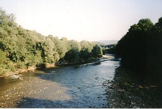
Skawa is a river in southern Poland, a right tributary of the Vistula. It originates in the Western Carpathians (Beskids), is 96 km long and drains 1,160 km². It passes several towns: Jordanów, Maków Podhalański, Sucha Beskidzka, Wadowice and Zator, and whole river is located within the territory of Lesser Poland Voivodeship.
Zawoja is a village in Southern Poland located close to Maków Podhalański. It is situated in Sucha County. With neighbouring village of Skawica it constitutes a rural Zawoja Commune. It has 6,200 inhabitants (2001) and is often mentioned as one of the biggest Polish villages. It is also very often referred as the longest one as it stretches for about 20 kilometres in a picturesque mountain valley. It lies approximately 9 kilometres (6 mi) south of Sucha Beskidzka and 52 km (32 mi) south-west of the regional capital Kraków.
Gmina Budzów is a rural gmina in Sucha County, Lesser Poland Voivodeship, in southern Poland. Its seat is the village of Budzów, which lies approximately 8 kilometres (5 mi) north-east of Sucha Beskidzka and 37 km (23 mi) south-west of the regional capital Kraków.
Gmina Bystra-Sidzina is a rural gmina in Sucha County, Lesser Poland Voivodeship, in southern Poland. Its seat is the village of Bystra; it also contains the village of Sidzina.
Gmina Jordanów is a rural gmina in Sucha County, Lesser Poland Voivodeship, in southern Poland. Its seat is the town of Jordanów, although the town is not part of the territory of the gmina.
Gmina Stryszawa is a rural gmina in Sucha County, Lesser Poland Voivodeship, in southern Poland. Its seat is the village of Stryszawa, which lies approximately 7 kilometres (4 mi) west of Sucha Beskidzka and 50 km (31 mi) south-west of the regional capital Kraków.
Gmina Zawoja is a rural gmina in Sucha County, Lesser Poland Voivodeship, in southern Poland, on the Slovak border. Its seat is the village of Zawoja, which lies approximately 9 kilometres (6 mi) south of Sucha Beskidzka and 52 km (32 mi) south-west of the regional capital Kraków. The gmina also contains the village of Skawica.
Gmina Zembrzyce is a rural gmina in Sucha County, Lesser Poland Voivodeship, in southern Poland. Its seat is the village of Zembrzyce, which lies approximately 5 kilometres (3 mi) north of Sucha Beskidzka and 40 km (25 mi) south-west of the regional capital Kraków.

Zielona Ulica is a village in the administrative district of Gmina Biecz, within Gorlice County, Lesser Poland Voivodeship, in southern Poland. It lies approximately 6 kilometres (4 mi) north-west of Biecz, 14 km (9 mi) north of Gorlice, and 97 km (60 mi) east of the regional capital Kraków.

Białka is a village in the administrative district of Gmina Maków Podhalański, within Sucha County, Lesser Poland Voivodeship, in southern Poland. It lies approximately 5 kilometres (3 mi) south of Maków Podhalański, 8 km (5 mi) south-east of Sucha Beskidzka, and 46 km (29 mi) south-west of the regional capital Kraków.
Grzechynia is a village in the administrative district of Gmina Maków Podhalański, within Sucha County, Lesser Poland Voivodeship, in southern Poland. It lies approximately 3 kilometres (2 mi) south-west of Maków Podhalański, 6 km (4 mi) south-east of Sucha Beskidzka, and 44 km (27 mi) south-west of the regional capital Kraków.
Juszczyn is a village in the administrative district of Gmina Maków Podhalański, within Sucha County, Lesser Poland Voivodeship, in southern Poland. It lies approximately 5 kilometres (3 mi) south of Maków Podhalański, 10 km (6 mi) south-east of Sucha Beskidzka, and 45 km (28 mi) south-west of the regional capital Kraków.
Kojszówka is a village in the administrative district of Gmina Maków Podhalański, within Sucha County, Lesser Poland Voivodeship, in southern Poland. It lies approximately 5 kilometres (3 mi) east of Maków Podhalański, 11 km (7 mi) east of Sucha Beskidzka, and 41 km (25 mi) south of the regional capital Kraków.
Żarnówka is a village in the administrative district of Gmina Maków Podhalański, within Sucha County, Lesser Poland Voivodeship, in southern Poland. It lies approximately 4 kilometres (2 mi) east of Maków Podhalański, 11 km (7 mi) east of Sucha Beskidzka, and 40 km (25 mi) south of the regional capital Kraków.

Stryszawa is a village, the seat of the administrative district of Gmina Stryszawa, within Sucha County, Lesser Poland Voivodeship, in southern Poland. It lies approximately 2 kilometres (1 mi) east of Lachowice, 6 km (4 mi) south-west of Sucha Beskidzka, and 49 km (30 mi) south-west of the regional capital Kraków.
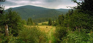
The Maków Beskids is a mountain range in south-central Poland, part of the Western Beskids within the Outer Western Carpathians.


