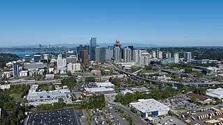
Bellevue is a city in the Eastside region of King County, Washington, United States, located across Lake Washington from Seattle. It is the third-largest city in the Seattle metropolitan area, and the fifth-largest city in Washington. It has variously been characterized as a satellite city, a suburb, a boomburb, or an edge city. The population was 151,854 at the 2020 census. The city's name is derived from the French term belle vue.

Newcastle is an Eastside city in King County, Washington, United States. The population was 13,017 at the 2020 census.

A log flume is a watertight flume constructed to transport lumber and logs down mountainous terrain using flowing water. Flumes replaced horse- or oxen-drawn carriages on dangerous mountain trails in the late 19th century. Logging operations preferred flumes whenever a reliable source of water was available. Flumes were cheaper to build and operate than logging railroads. They could span long distances across chasms with more lightweight trestles.
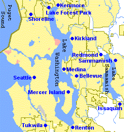
The Eastside of the King County, Washington area in the United States is a collective term for the suburbs of Seattle located on the east side of Lake Washington.

Bellevue School District No. 405 (BSD) is a public school district in King County, headquartered in Bellevue. As of October 1, 2016, the district has an enrollment of 19,974 students.
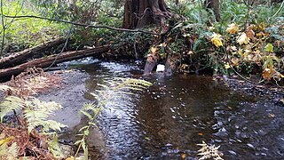
Kelsey Creek is a creek in Bellevue, Washington on Seattle's Eastside. Originating in the wetlands in the Lake Hills greenbelt between Phantom Lake and Larsen Lake, it flows north and west through the Crossroads neighborhood and then south to Kelsey Creek Park where it turns west and becomes the Mercer Slough just west of Interstate 405. The centerpiece of the largest wetland adjacent to Lake Washington at 367 acres (149 ha), the slough empties into the East Channel of Lake Washington at Interstate 90.

Algoma is an unincorporated community on the east shore of Upper Klamath Lake, in Klamath County, Oregon, United States. It is about 8 miles (13 km) north of the city of Klamath Falls on U.S. Route 97. Algoma was named for the Algoma Lumber Company.
Kennydale is a neighborhood in Renton, Washington, in the United States. As of 2008, it had an estimated population of 4,840. It lies along the southeastern shore of Lake Washington and straddles Interstate 405 which runs north-south between Renton and Bellevue, and borders the Newport Shores neighborhood of Bellevue. The part of the neighborhood on the lake (west) side of I-405 is referred to as "Lower Kennydale", and on the east side "Upper Kennydale".

Wendling is an unincorporated community in Lane County, Oregon, United States, located northeast of Marcola. Wendling's post office operated from 1899 to 1952. The town was named for George X. Wendling, a San Francisco investor, who was the largest investor in Booth-Kelly's expansion into the Mohawk. Wendling was created as a company town for the Booth-Kelly Lumber Company.
Bucksport was a town in Humboldt County, California. The original location was 2.5 miles (4 km) southwest of downtown Eureka, on Humboldt Bay about 5 miles (8 km) northeast of entrance. at an elevation of 16 feet (4.9 m). Prior to American settlement a Wiyot village named Kucuwalik stood here.
Korbel is an unincorporated community in Humboldt County, California. It is located 1.5 miles (2.4 km) east-southeast of Blue Lake, at an elevation of 154 feet. The ZIP Code is 95550.

Andersonia is an unincorporated community in Mendocino County, California. It is located near U.S. Route 101 on the South Fork of the Eel River 1 mile (1.6 km) north-northwest of Piercy, at an elevation of 541 feet.

Sherwood Creek is a creek in Mason County, Washington fed by Mason Lake. It runs through the small town of Allyn, Washington, before releasing into the Case Inlet at the base of the Kitsap Peninsula. It is a popular local picnic and camping spot.

The Hume-Bennett Lumber Company was a logging operation in the Sequoia National Forest in the late 19th and early 20th centuries. The company and its predecessors were known for building the world's longest log flume and the first multiple-arch hydroelectric dam. However, the company also engaged in destructive clearcutting logging practices, cutting down 8,000 giant sequoias in Converse Basin in a decade-long event that has been described as "the greatest orgy of destructive lumbering in the history of the world."
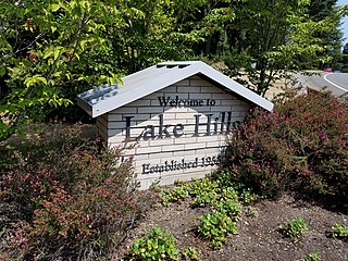
Lake Hills is a neighborhood in Bellevue, Washington. It lies to the south of the Crossroads and north of the Eastgate neighborhoods.

Lake Bellevue, also called Lake Sturtevant, is a small lake inside the city limits of Bellevue, Washington. Along with Phantom Lake and Larsen Lake, it is one of three small lakes inside the city, which also borders Lake Washington and Lake Sammamish. Sturtevant Creek, a tributary of Kelsey Creek, has its origin at Lake Bellevue and contains Chinook, Sockeye and Coho salmon. In the 773-acre (313 ha) creek basin, 71% of the land has an impervious surface.
The Gilmour Lumber Company was one of the giants of the Canadian timber industry. Their involvement in lumbering began modestly in the 1790s in the area of Glasgow, Scotland where Allan Gilmour Sr. started a small timber merchandising business. In 1804 he entered into a partnership with his cousins John and Arthur and formed Pollock, Gilmour and Company. Pollock, Gilmour and Company became ship owners and imported products in Europe and the Baltic region.
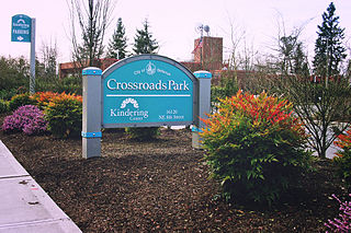
Crossroads is a neighborhood in Bellevue, Washington. It is situated in the north and eastern portion of the city, lying south of Bellevue-Redmond Road, east of Bellevue's Wilburton neighborhood, and north of Lake Hills.

The Sugar Pine Lumber Company was an early 20th century logging operation and railroad in the Sierra Nevada. Unable to secure water rights to build a log flume, the company operated the “crookedest railroad ever built." They later developed the Minarets-type locomotive, the largest and most powerful saddle tank locomotive ever made. The company was also a pioneer in the electrification of logging where newly plentiful hydroelectric power replaced the widespread use of steam engines.

Millwood was a lumber boomtown located in present-day Sequoia National Forest near Converse Basin Grove in California. It was established in 1891 by the Kings River Lumber Company and was connected to the Sequoia Railroad, which brought logs to the town to be turned into rough lumber. The lumber was then transported by log flume to Sanger, a journey of 54 miles. At its peak, Millwood had a population of over 2,000 people and featured two hotels, a summer school, and a post office. However, today there are no remaining structures or buildings at the Millwood site.

