Altenkirchen is a district in Rhineland-Palatinate, Germany. It is bounded by the North Rhine-Westphalian districts Rhein-Sieg, Oberbergischer Kreis, Olpe and Siegen-Wittgenstein, and the districts of Westerwaldkreis and Neuwied.
The Hunsrück is a low mountain range in Rhineland-Palatinate, Germany. It is bounded by the river valleys of the Moselle (north), the Nahe (south), and the Rhine (east). The Hunsrück is continued by the Taunus mountains on the eastern side of the Rhine. In the north behind the Moselle it is continued by the Eifel. To the south of the Nahe is the Palatinate region.

The Kellerwald is a low mountain range reaching heights of up to 675 m in the western part of northern Hesse, Germany. Its assets include Germany's largest contiguous beech woodland and it contains Hesse's only national park, the Kellerwald-Edersee National Park. It is a UNESCO World Heritage Site.
Bollenbach is an Ortsgemeinde – a municipality belonging to a Verbandsgemeinde, a kind of collective municipality – in the Birkenfeld district in Rhineland-Palatinate, Germany. It belongs to the Verbandsgemeinde of Rhaunen, whose seat is in the like-named municipality.

'Friesenhagen' is a municipality in the north of the district of Altenkirchen, in Rhineland-Palatinate, in Western Germany.

Bruchweiler is an Ortsgemeinde – a municipality belonging to a Verbandsgemeinde, a kind of collective municipality – in the Birkenfeld district in Rhineland-Palatinate, Germany. It belongs to the Verbandsgemeinde of Herrstein, whose seat is in the like-named municipality.
Breitenthal (Hunsrück) is an Ortsgemeinde – a municipality belonging to a Verbandsgemeinde, a kind of collective municipality – in the Birkenfeld district in Rhineland-Palatinate, Germany. It belongs to the Verbandsgemeinde of Herrstein, whose seat is in the like-named municipality.

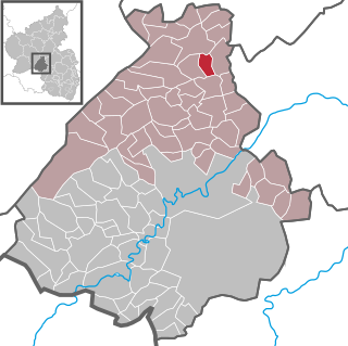
Kempfeld is an Ortsgemeinde – a municipality belonging to a Verbandsgemeinde, a kind of collective municipality – in the Birkenfeld district in Rhineland-Palatinate, Germany. It belongs to the Verbandsgemeinde of Herrstein, whose seat is in the like-named municipality.

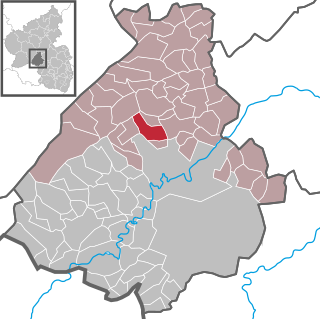
Kirschweiler is an Ortsgemeinde – a municipality belonging to a Verbandsgemeinde, a kind of collective municipality – in the Birkenfeld district in Rhineland-Palatinate, Germany. It belongs to the Verbandsgemeinde of Herrstein, whose seat is in the like-named municipality.

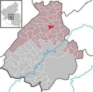
Herborn is an Ortsgemeinde – a municipality belonging to a Verbandsgemeinde, a kind of collective municipality – in the Birkenfeld district in Rhineland-Palatinate, Germany. It belongs to the Verbandsgemeinde of Herrstein, whose seat is in the like-named municipality.
Veitsrodt is an Ortsgemeinde – a municipality belonging to a Verbandsgemeinde, a kind of collective municipality – in the Birkenfeld district in Rhineland-Palatinate, Germany. It belongs to the Verbandsgemeinde of Herrstein, whose seat is in the like-named municipality.

Langweiler is an Ortsgemeinde – a municipality belonging to a Verbandsgemeinde, a kind of collective municipality – in the Birkenfeld district in Rhineland-Palatinate, Germany. It belongs to the Verbandsgemeinde of Herrstein, whose seat is in the like-named municipality.

The Soonwald is a forested, low mountain region, up to 657.5 m above sea level (NN), which forms part of the Hunsrück mountains in the German Central Uplands. It lies within the counties of Rhein-Hunsrück-Kreis and Bad Kreuznach in the state of Rhineland-Palatinate.
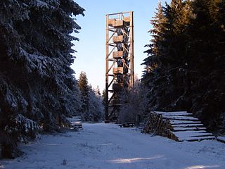
Idarkopf Tower, also known as Idarkopf Observation Tower for long, is a wooden German lattice observation tower on the summit of Mt. Idarkopf in the state of Rhineland-Palatinate. The observation tower on the 746 m-high (2,448 ft) mountain of Idarkopf has a total height of 28.50 m (94 ft). Built in 1980, the tower was constructed according to a certain kind of specialized wooden frame and was designed through triangular sketch. Staircases are uncountable because of the vast number of steps. The roof, which contains the observation deck, is considered the highest accessible point in the whole area, providing a unique view of the town nearby.

The Saar-Hunsrück Nature Park was established in 1980 and covers an area of just under 2,000 km² in the German states of Rhineland-Palatinate and the Saarland.

Wildenburg Castle is a ruined castle near Kempfeld in the county of Birkenfeld in the German state of Rhineland-Palatinate.
Wildburg may refer to the follow castles in Germany:


