
Thomas Lynch (1727–1776) was an American planter and statesman from South Carolina. He was a delegate to the Stamp Act Congress of 1765 and the Continental Congress from 1774 to 1776.

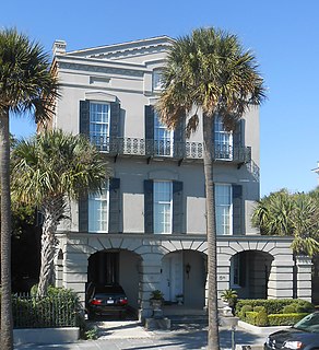
The Robert William Roper House is a historic house at 9 East Battery in Charleston, South Carolina. It was built on land purchased in May 1838 by Robert W. Roper, a prominent cotton planter. The house is an outstanding example of early 19th Century Greek Revival architecture, built on a monumental scale. Although there are now two houses between the Roper House and White Point Garden to the south, at the time of its construction nothing stood between the house and the harbor beyond. It is said that Mr. Roper "had wanted his house to be the first and most prominent to be seen as visitors approached Charleston by sea."

The Col. William Rhett House is a historic, stuccoed brick two-story home at 54 Hasell St., Charleston, South Carolina. It was built in 1712 as the main house for Point Plantation later known as Rhettsbury, lying outside the walled city's limits by Col. William Rhett. The plantation was later folded into the historic Ansonborough neighborhood.

The James Simmons House is a late 18th-century house at 37 Meeting Street, Charleston, South Carolina which was, at one time, the most expensive house sold in Charleston. It was likely built for James Simmons, a lawyer. By 1782, it was home to Robert Gibbes, a planter. Louisa Cheves, a prominent antebellum writer, was born at the house on December 3, 1810. In 1840, Otis Mills, the owner of the Mills House Hotel, bought the house for $9,000. In October 1862, during the Civil War, the house was loaned to Gen. Pierre Beauregard, who used the house as his headquarters until August 1863. In 1876, Michael P. O'Connor, later a member of Congress, bought the house.

The Louis DeSaussure House is an antebellum house at 1 East Battery, Charleston, South Carolina. The house was designed and built for Louis DeSaussure by William Jones and completed in late 1859. The three-story, masonry house follows a traditional side hall plan; two adjacent parlors are fronted with piazzas along the south side while a stair hall runs along the north side with a front door facing east onto East Battery. In 1865 during the Civil War, the house was damaged when evacuating Confederate forces blew up a large cannon at the corner of East Battery and South Battery; a piece of the cannon was lodged in the attic of the house. The balconies on the East Battery façade and window ornaments were installed when the house was restored after the earthquake of 1886 by Bernard O'Neill, who bought it in 1888. The house was used by the military to house Navy officers during World War II and was later converted into apartments. The carriage house for 1 East Battery was later subdivided into a separate house known as 2 South Battery.

The Ralph Izard is a pre-Revolutionary house at 110 Broad St., Charleston, South Carolina. Although the house is known as the Ralph Izard House, it was likely built by a former owner, William Harvey. The house was listed in the will of Izard of September 1757, but Izard had only acquired the parcel three months before his death.
The William Ravenel House was built in 1845 by shipping merchant William Ravenel. The drawing room runs the entire width of the house and is perhaps the largest drawing room in Charleston. The house suffered severe damage in the 1886 Charleston earthquake; its giant order Tower of the Winds portico was destroyed, leaving only the base. One of the capitals from the columns was unearthed 73 years later when Hurricane Gracie felled a tree which had grown atop the capital where it had fallen and been imbedded in the soft soil. The drawing room of the house spans the width of the house and has been described as the largest room in Charleston.

The Elias Vanderhorst House at 28 Chapel Street, Charleston, South Carolina, is a four-story mansion house which was built around 1835 as a home for members of the prominent Vanderhorst family of plantation owners.

The Col. John A.S. Ashe House is a historic home in Charleston, South Carolina along Charleston's Battery. Col. John A.S. Ashe, Jr. received the property upon which 26 South Battery is built upon his father's death in 1828 along with $10,000 for the construction of a house. Col. John A.S. Ashe, Jr.'s father had built the nearby Col. John Ashe House at 32 South Battery in the 1780s.
The John Lining House is one of the oldest houses in Charleston. Although the lot upon which the house stands was first conveyed to French Huguenot immigrant Jaques DeBordeaux in 1694, it is uncertain when the house was built; the first mention of a house appears in a 1715 deed by which the property, including a dwelling, was conveyed to William Harvey, Jr. In 1757, the house was received by Mrs. Sarah Lining, the wife of Dr. John Lining. Although the couple owned the house for less than one year before transferring it to John Rattray, Dr. Lining's name stuck as the name of the dwelling. In 1780, the building was acquired by Dr. Andrew Turnbull, the founder of New Smyrna, Florida, who opened in the house the first of a long series of apothecary shops which remained until 1960.

The Capers-Motte House is a pre-Revolutionary house at 69 Church Street in Charleston, South Carolina. The house was likely built before 1745 by Richard Capers. Later, the house purchased and became the home of Colonel Jacob Motte, who served as the treasurer of the colony for 27 years until his death in 1770. His son, also named Jacob Motte, married Rebecca Brewton, daughter of goldsmith Robert Brewton and sister of Miles Brewton, a wealthy slave trader.
The George Eveleigh House is a pre-Revolutionary house in Charleston, South Carolina. The house was built about 1743 for trader George Eveleigh. Eventually, Eveleigh returned to England and sold his house to John Bull in 1759. John Bull or one of his heirs subsequently built the house at 34 Meeting Street on the rear of the property; the parcel had originally run from Church Street through the block to Meeting Street on the west. The house retains much of its original cypress woodwork although many of the fireplace mantels were replaced in the Adam period.
The Robert Pringle House is a historic house in Charleston, South Carolina.
The William Vanderhorst House was used as the first post office in Charleston, South Carolina before 1753. Eleazer Philips was the first postmaster of Charleston to have a dedicated office for the handling of the mail, and he used 54 Tradd Street for that purpose. Earlier postmasters handled the mail in their own houses. The house was used as a post office until after 1791 when Peter Bacot relocated the operation to 84 Broad Street.

The Isaac Holmes Tenement is a pre-Revolutionary house in Charleston, South Carolina. In 1721, Isaac Holmes acquired the parcel upon which 107 Church Street was built. It appears that he built a house on the land, but whatever structure he had built was lost in a fire in 1740 that wiped out many buildings in the area.

The Daniel Elliott Huger House was the last home of a Royal governor in South Carolina.

The James Vanderhorst House at 46 Tradd Street is a pre-Revolutionary house which is most famous for its connection to American artist Alfred Hutty.
The Dr. Peter Fayssoux House is a pre-Revolutionary house built about 1732 for Alexander Smith. After the Revolutionary War, the Georgian house was home to Dr. Peter Fayssoux, the surgeon general of the Continental Army.

The Humphrey Sommers House is a pre-Revolutionary house in Charleston, South Carolina. Humphrey Sommers, who worked as the main contractor for St. Michael's Episcopal Church, is said to have built the house while working on the church; if so, the house can be dated to 1753 to 1762. The house began as a traditional Charleston single house, and it was entered through the ground floor. The L-shape of the house, formed by an addition at the northwest corner of the house, was in place by 1788 when the house can be seen on a map of the city. Still later, broad piazzas were added to the west side of the house, and the main entrance was relocated to the second floor of the house atop a curving staircase to the second level of the piazzas. The piazzas were not present when the house was sold in 1830 to the widow of United States Representative William Lowndes.


