
Franklin County is a county in the Commonwealth of Pennsylvania. As of the 2020 census, the population was 155,932. Its county seat is Chambersburg.

Franklin Township is a township in Adams County, Pennsylvania, United States. The population was 4,676 at the 2020 census.

The Wedge is a 1.068-square-mile tract of land along the borders of Delaware, Maryland and Pennsylvania. Ownership of the land was disputed until 1921; it is now recognized as part of Delaware. The tract was created primarily by the shortcomings of contemporary surveying techniques when the boundaries were defined in the 18th century. It is bounded on the north by an eastern extension of the east–west portion of the Mason–Dixon line, on the west by the north–south portion of the Mason–Dixon line, and on the southeast by the Twelve-Mile Circle around New Castle, Delaware. The crossroads community of Mechanicsville, Delaware, lies within the area today.

Seminary Ridge is a dendritic ridge that served as an area of military engagements during the Battle of Gettysburg, the bloodiest battle of the American Civil War, which was fought between July 1 and July 3, 1863 in and around Gettysburg, Pennsylvania. Seminary Ridge also served as a military installation during World War II.
Back Creek is a 16.8-mile-long (27.0 km) tributary of Conococheague Creek in south central Pennsylvania in the United States.
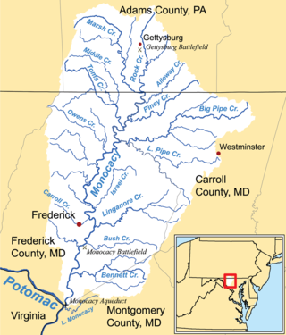
Marsh Creek is a 26.6-mile-long (42.8 km) tributary of the Monocacy River in south-central Pennsylvania and north-central Maryland in the United States.

Rock Creek is an 18.9-mile-long (30.4 km) tributary of the Monocacy River in south-central Pennsylvania and serves as the border between Cumberland and Mount Joy townships. Rock Creek was used by the Underground Railroad and flows near several Gettysburg Battlefield sites, including Culp's Hill, the Benner Hill artillery location, and Barlow Knoll.
Little Conococheague Creek is a 12.4-mile-long (20.0 km) tributary stream of the Potomac River in the U.S. states of Maryland and Pennsylvania. The stream rises on Two Top Mountain, west of the Whitetail Ski Resort in Franklin County, Pennsylvania, and proceeds south into Washington County, Maryland. It empties into the Potomac about 2 miles (3 km) southeast of Big Spring, Maryland. The watershed of the creek is 18 square miles (47 km2) and includes Indian Springs Wildlife Management Area. Tributaries include Toms Run.
Lick Run is a 17.2-mile-long (27.7 km) tributary of the West Branch Susquehanna River in Clinton County, Pennsylvania in the United States.

Nittany Valley is an eroded anticlinal valley located in Centre County, Pennsylvania. It is separated from the Bald Eagle Valley by Bald Eagle Mountain and from Penns Valley by Mount Nittany. The valley is closed to the north by a high plateau that joins these two mountain ridges, but is open to the south at the southern terminus of Mount Nittany. The valley drains to Bald Eagle Creek through water gaps in Bald Eagle Mountain formed by Spring Creek and Fishing Creek, along with smaller streams running through Curtain Gap and Howard Gap. The northwest side of the valley between the Bald Eagle Mountain ridge and the lower Sand Ridge is also known as the Little Nittany Valley.

Parnell Knob is a mountain in the Ridge and Valley Appalachians region of south central Pennsylvania. This knob rises above the village of St. Thomas, where Front Mountain and Broad mountain come together. It is a feature sculptured by the hard dense Tuscarora quartzite of the Silurian age. Parnell Knob is conspicuous in that it rises abruptly above the relatively level Great Appalachian Valley.
Woodbine is an unincorporated community in York County, Pennsylvania, United States. Until 1978, this community was served by the Maryland and Pennsylvania Railroad at milepost 50.6.
Squatter's Row was a historic neighborhood in the downtown area of Omaha, Nebraska. It was an area between North 11th and North 13th Streets, from Nicholas to Locust Streets, behind the Storz Brewery. For more than 75 years this area was inhabited solely by squatters. A village of shacks built of materials salvaged from the Omaha city dump, the neighborhood included different enclaves such as Vinegar Flats, Blind Pig Alley, among others.
White Run is a Pennsylvania stream which flows along the Gettysburg National Military Park and is an eponym of the Rock Creek-White Run hospital complex for field hospitals of the Battle of Gettysburg. The run's mouth is at Rock Creek near the Trostle Farm along the Sachs Road, site of a hospital east of Round Top, Pennsylvania.

Pitzer Run is a Pennsylvania stream flowing southward between McPherson Ridge and Seminary and Warfield Ridges through the Gettysburg Battlefield to Willoughby Run at the site of Pitzer's School, which was Confederate General Longstreet's headquarters during the Battle of Gettysburg.
Blocher's Run is a Pennsylvania stream which flows from Oak Ridge on the Gettysburg Battlefield eastward to the Rock Creek through and near areas of the Battle of Gettysburg, First Day.
Herriottsville is an unincorporated community in South Fayette Township, Allegheny County, Pennsylvania, United States. The community is located in the southeast corner of the township near Chartiers Run. Herriottsville had one of the first post offices in South Fayette Township and was a stagecoach stop on the Black Horse Trail.
Westland is a census-designated place that is located in Mount Pleasant and Chartiers Townships in Washington County in the Commonwealth of Pennsylvania in the United States.
Southport is an unincorporated community in Washington Township, Owen County, in the U.S. state of Indiana.
South Mountains are a range of mountains primarily in White Pine County, Nevada and partially to the east in Juab County, Utah. The range is sometimes referred to as the Deep Creek Mountains, or the Ibenpah Mountains. The South Mountains are divided from the Kern Mountains to the south by Tippett Canyon on the west and Pleasant Valley to the east. They are divided from the Deep Creek Range to the east in Utah by Johnson Canyon, on the north, and by Water Canyon on the south. The range is bounded on the north by Spring Creek Flat and on the west by Antelope Valley.
