
Horsetooth Reservoir is a large reservoir in southern Larimer County, Colorado, in the foothills just west of the city of Fort Collins, Colorado. The reservoir runs north-south for approximately 6.5 miles (10 km) and is approximately one-half mile (1 km) wide. Its shape and orientation are the result of the fact that the main body of the reservoir is contained between several homoclinal ridges. A ridge composed of Dakota sandstone runs along the east side where gaps in the ridge are plugged by dams. On the west (uphill) side there are two prominent ridges topped by erosion-resistant sandstones of the Lyons and Ingleside formations. Gaps in these ridges have created a handful of bays and coves the largest of which is Inlet Bay, home to a marina and campgrounds.

The Colorado–Big Thompson Project is a federal water diversion project in Colorado designed to collect West Slope mountain water from the headwaters of the Colorado River and divert it to Colorado's Front Range and plains. In Colorado, approximately 80% of the state's precipitation falls on the West Slope, in the Rocky Mountains, while around 80% of the state's growing population lives along the eastern slope, between the cities of Fort Collins and Pueblo.

Flaming Gorge Dam is a concrete thin-arch dam on the Green River, a major tributary of the Colorado River, in northern Utah in the United States. Flaming Gorge Dam forms the Flaming Gorge Reservoir, which extends 91 miles (146 km) into southern Wyoming, submerging four distinct gorges of the Green River. The dam is a major component of the Colorado River Storage Project, which stores and distributes upper Colorado River Basin water.

Blue Mesa Reservoir is an artificial reservoir located on the upper reaches of the Gunnison River in Gunnison County, Colorado. The largest lake located entirely within the state, Blue Mesa Reservoir was created by the construction of Blue Mesa Dam, a 390-foot tall earthen fill dam constructed on the Gunnison by the U.S. Bureau of Reclamation in 1966 for the generation of hydroelectric power. Managed as part of the Curecanti National Recreation Area, a unit of the National Park Service, Blue Mesa Reservoir is the largest lake trout and Kokanee salmon fishery in Colorado.

Yellowtail Dam is a dam across the Bighorn River in south central Montana in the United States. The mid-1960s era concrete arch dam serves to regulate the flow of the Bighorn for irrigation purposes and to generate hydroelectric power. The dam and its reservoir, Bighorn Lake, are owned by the U.S. Bureau of Reclamation.
The Central Utah Project is a US federal water project that was authorized for construction under the Colorado River Storage Project Act of April 11, 1956, as a participating project. In general, the Central Utah Project develops a portion of Utah's share of the yield of the Colorado River, as set out in the Colorado River Compact of 1922.

Scofield Reservoir is a 2,815-acre (11.39 km2) reservoir impounded by Scofield Dam, in Carbon County, Utah. Located on the Price River, a tributary of the Green River, Scofield Reservoir is adjacent to the northernmost boundary of the Manti–La Sal National Forest. The reservoir sits at an elevation of 7,618 feet (2,322 m), on the northern edge of the Wasatch Plateau. Utah State Route 96 runs along the western shoreline.
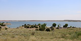
Lake Pueblo State Park is a state park located in Pueblo County, Colorado. It includes 60 miles (97 km) of shoreline and 10,000 acres (40 km2) of land. Activities it offers include two full-service marinas, recreational fishing, hiking, camping and swimming at a special swim beach.

The Alva B. Adams Tunnel is the principal component of the largest transmountain water project in Colorado, the Colorado-Big Thompson Project (C-BT). The tunnel transfers water from the western slope of the Colorado River drainage to the eastern Front Range of Colorado. It is 13.1 miles (21.1 km) long, with a concrete lined diameter of 9.75 feet (2.97 m). The tunnel drops 109 feet (33 m) in elevation along its length and runs in a straight line under the Continental Divide from west to east, passing under Otis Peak in Rocky Mountain National Park. At its deepest point, the tunnel is about 3,800 feet (1,200 m) below the surface of the mountain peaks. Construction began on 15 June 1940, but was suspended as a result of World War II priorities, from the end of 1942 to August 1943. The tunnel was holed through on 31 March 1944, an event that was broadcast throughout the United States by NBC Radio. The tunnel was posthumously named for its chief advocate, US Senator Alva B. Adams.
Currant Creek Dam is a dam in Wasatch County, Utah.

Crawford Dam impounds water for Crawford Reservoir in Delta County, Colorado about a mile south of the town of Crawford.
Red Willow Dam is a dam in Frontier County, Nebraska, about ten miles northwest of McCook.
Lost Creek Dam is a dam in Morgan County, Utah, United States.

Rifle Gap Dam is a dam in Garfield County, Colorado, about five and a half miles north of Rifle.

Prosser Creek Dam is a dam in Nevada County, California.

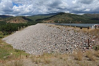
Carter Lake Dam is a dam in Larimer County, Colorado.
Vallecito Dam is a dam in La Plata County, Colorado about 18 miles (29 km) northeast of Durango.
Twin Lakes Dam is a dam in Lake County, Colorado, about 13 miles south of Leadville.
Willow Creek Dam is a dam in Lewis and Clark County, Montana.

Heron Dam is a storage dam Rio Arriba County, in northern New Mexico in the southwestern United States, just north of the El Vado Dam. It is owned and operated by the United States Bureau of Reclamation. The dam is about 9 miles west of the town of Tierra Amarilla.
